
Station GI CMSM - San Martin Jilotepeque, Chimaltenango
Network: GI - Red Sismologica Nacional- Guatemala
Nearby stations (2 deg radius)
| Station | Name | (Lat, Lon) | Start / End | Elevation |
| CMSM | San Martin Jilotepeque, Chimaltenango | (14.78, -90.79) | 2021-06-13 / 2499-01-01 | 1970 m |
| Crust2 Type: | L8,thin continental arc, Cordilleras, 0.5 km seds. |
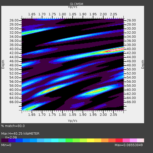
| Thickness Estimate: | 40 km |
| Thickness StdDev: | 7.3 km |
| Vp/Vs Estimate: | 2.07 |
| Vp/Vs StdDev: | 0.14 |
| Vs Estimate: | 3.18 km/s |
| Poisson's Ratio: | 0.35 |
| Peak Value: | 0.07 |
| Assumed Vp: | 6.566 km/s |
| Ps Weight: | 0.33333334 |
| PpPs Weight: | 0.33333334 |
| PsPs Weight: | 0.33333328 |
| Residual Complexity: | 0.656 |
| Nearby stations H: | +- |
| (2.0 deg) Vp/Vs: | +- |
1 with match > 90% ( 2.3809524 %) and 6 with match > 80% ( 14.285714 %) out of 42.
Download stack as xyz text file.
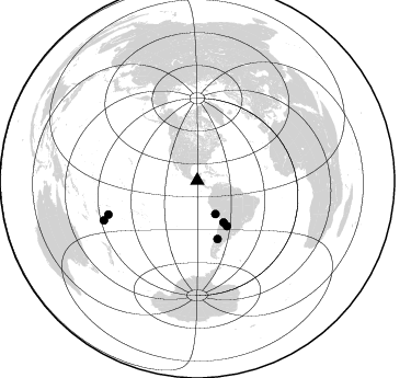
Azimuth Distribution of Events:
Prior Results for this Station
| Study | Thickness | Vp/Vs | Vp | Vs | Poissons Ratio | Extra |
| EARS | 40 km | 2.07 | 6.566 km/s | 3.18 km/s | 0.35 | |
| Crust2.0 | 34 km | 1.77 | 6.566 km/s | 3.707 km/s | 0.27 | L8,thin continental arc, Cordilleras, 0.5 km seds. |
| Global Maxima | 40 km | 2.07 | 6.566 km/s | 3.18 km/s | 0.35 | amp=0.07458432 |
| Local Maxima 1 | 60 km | 1.97 | 6.566 km/s | 3.337 km/s | 0.33 | amp=0.04217326 |
| Local Maxima 2 | 32 km | 1.63 | 6.566 km/s | 4.028 km/s | 0.20 | amp=0.031792287 |
| Local Maxima 3 | 60 km | 1.74 | 6.566 km/s | 3.785 km/s | 0.25 | amp=0.028769681 |
| Local Maxima 4 | 34 km | 1.85 | 6.566 km/s | 3.544 km/s | 0.29 | amp=0.022681734 |
| Predicted Arrivals for vertical incidence (zero ray parameter) | |
| Ps | 6.53 SECOND |
| PpPs | 18.79 SECOND |
| PsPs/PpSs | 25.32 SECOND |
Events Processed for this Station
Download zip of receiver functions as SAC
Plot maxima for each earthquake.
Events Used in the Stack
(6 events)| Radial Match | Distance | Baz | FERegion | Time | Lat/Lon | Depth | Magnitude |
| 92.0133 | 86.9 deg | 249.218 deg | Tonga Islands Region | 2022/11/11 10:48:45 UTC | (-19.3, -172.1) | 25 km | 7.3 Mww |
| 85.693855 | 56.1 deg | 160.649 deg | Southern Argentina | 2023/07/17 03:05:10 UTC | (-38.2, -70.4) | 171 km | 6.6 mww |
| 83.70058 | 34.4 deg | 151.358 deg | Near Coast Of Peru | 2024/06/28 05:36:37 UTC | (-15.8, -74.4) | 28 km | 7.2 mww |
| 81.04897 | 92.4 deg | 247.013 deg | South Of Fiji Islands | 2023/06/15 18:06:27 UTC | (-23.0, -177.2) | 167 km | 7.2 Mww |
| 80.60863 | 49.3 deg | 146.668 deg | Santiago Del Estero Prov., Arg. | 2023/01/20 22:09:39 UTC | (-26.7, -63.0) | 611 km | 6.8 mww |
| 80.5134 | 44.8 deg | 147.62 deg | Jujuy Province, Argentina | 2023/03/22 16:00:31 UTC | (-23.5, -66.5) | 210 km | 6.5 mww |
Losers
(36 events)| Radial Match | Distance | Baz | FERegion | Time | Lat/Lon | Depth | Magnitude | Reason |
| 82.954506 | 91.9 deg | 246.947 deg | South Of Fiji Islands | 2023/06/15 18:06:29 UTC | (-22.9, -176.6) | 206 km | 7.0 Mi | |
| 77.56124 | 86.5 deg | 253.585 deg | Tonga Islands | 2023/08/08 18:38:56 UTC | (-15.0, -173.0) | 120 km | 6.2 Mi | |
| 75.10715 | 90.5 deg | 249.659 deg | Tonga Islands | 2024/03/31 03:01:44 UTC | (-19.9, -176.0) | 10 km | 5.5 Mww | |
| 73.53313 | 96.6 deg | 238.027 deg | South Of Kermadec Islands | 2023/09/08 09:09:58 UTC | (-32.7, -179.3) | 90 km | 6.6 mww | |
| 72.80745 | 44.5 deg | 146.832 deg | Jujuy Province, Argentina | 2023/10/10 10:01:31 UTC | (-22.9, -66.2) | 247 km | 6.0 Mww | |
| 68.7415 | 40.0 deg | 147.042 deg | Northern Chile | 2023/12/02 07:55:40 UTC | (-19.2, -69.1) | 106 km | 5.8 Mww | |
| 68.627815 | 76.0 deg | 321.006 deg | Andreanof Islands, Aleutian Is. | 2023/10/16 11:35:31 UTC | (52.4, -176.9) | 187 km | 6.4 Mww | |
| 66.25662 | 75.2 deg | 321.601 deg | Andreanof Islands, Aleutian Is. | 2023/10/16 11:35:30 UTC | (53.1, -175.5) | 253 km | 6.7 Mi | |
| 65.68596 | 53.9 deg | 330.869 deg | Off Coast Of Southeastern Alaska | 2024/01/12 07:46:21 UTC | (56.5, -136.0) | 0.6 km | 5.9 mww | |
| 65.57552 | 95.4 deg | 241.089 deg | Kermadec Islands, New Zealand | 2023/03/04 06:41:22 UTC | (-29.5, -178.8) | 206 km | 6.9 mww | |
| 64.39841 | 50.4 deg | 147.95 deg | Santiago Del Estero Prov., Arg. | 2023/08/05 07:20:07 UTC | (-28.2, -63.2) | 598 km | 6.2 Mww | |
| 64.37089 | 92.8 deg | 250.049 deg | Fiji Islands Region | 2022/11/12 07:09:14 UTC | (-20.1, -178.4) | 587 km | 7.0 mww | |
| 62.3418 | 45.8 deg | 155.877 deg | Near Coast Of Northern Chile | 2023/09/15 18:07:39 UTC | (-27.3, -71.6) | 4.9 km | 5.7 mww | |
| 62.016636 | 52.4 deg | 156.483 deg | Mendoza Province, Argentina | 2022/11/05 12:12:39 UTC | (-33.4, -68.6) | 27 km | 5.0 Mww | |
| 61.770424 | 89.7 deg | 44.487 deg | Central Italy | 2022/11/09 06:07:27 UTC | (43.9, 13.3) | 10 km | 5.6 mww | |
| 59.917747 | 88.2 deg | 150.077 deg | South Sandwich Islands Region | 2023/11/30 07:54:57 UTC | (-56.3, -27.4) | 99 km | 5.8 mww | |
| 59.67719 | 92.9 deg | 138.202 deg | Southern Mid-Atlantic Ridge | 2023/06/09 20:43:28 UTC | (-47.3, -12.7) | 10 km | 5.5 mb | |
| 59.31709 | 52.8 deg | 162.341 deg | Off Coast Of Central Chile | 2023/03/30 17:33:06 UTC | (-35.7, -73.5) | 12 km | 6.3 mww | |
| 58.79109 | 79.1 deg | 205.339 deg | Pacific-Antarctic Ridge | 2023/08/06 04:04:27 UTC | (-54.3, -136.6) | 10 km | 5.5 Mww | |
| 58.628635 | 42.7 deg | 81.505 deg | Northern Mid-Atlantic Ridge | 2024/03/25 05:22:17 UTC | (16.6, -46.5) | 10 km | 5.5 mww | |
| 57.64729 | 41.2 deg | 318.829 deg | Off Coast Of Oregon | 2024/03/27 03:23:04 UTC | (42.3, -126.6) | 10 km | 5.7 mww | |
| 57.336143 | 58.9 deg | 51.517 deg | Azores Islands Region | 2023/01/02 07:20:27 UTC | (40.5, -29.4) | 10 km | 5.3 Mww | |
| 56.46757 | 88.0 deg | 249.457 deg | Tonga Islands | 2023/05/21 05:23:11 UTC | (-19.4, -173.3) | 10 km | 5.8 Mww | |
| 55.498333 | 90.4 deg | 246.812 deg | Tonga Islands Region | 2023/07/21 19:01:43 UTC | (-22.6, -175.0) | 11 km | 5.5 Mww | |
| 55.439613 | 75.5 deg | 198.169 deg | Southern East Pacific Rise | 2024/05/18 23:57:41 UTC | (-55.9, -123.2) | 10 km | 5.9 Mww | |
| 53.56111 | 45.4 deg | 212.29 deg | Southern East Pacific Rise | 2023/12/10 13:29:28 UTC | (-24.0, -115.4) | 10 km | 5.5 Mww | |
| 52.379086 | 72.6 deg | 320.976 deg | Fox Islands, Aleutian Islands | 2023/10/12 02:41:11 UTC | (52.6, -171.2) | 125 km | 5.5 ml | |
| 48.727306 | 51.1 deg | 194.306 deg | West Chile Rise | 2023/12/07 01:17:44 UTC | (-34.9, -104.3) | 10 km | 5.8 Mww | |
| 47.81926 | 75.6 deg | 320.046 deg | Andreanof Islands, Aleutian Is. | 2022/11/06 10:02:04 UTC | (51.6, -176.0) | 48 km | 5.1 Mww | |
| 47.49655 | 77.7 deg | 204.522 deg | Pacific-Antarctic Ridge | 2024/06/09 09:55:49 UTC | (-53.9, -134.0) | 10 km | 6.2 mww | |
| 47.14872 | 77.8 deg | 205.217 deg | Pacific-Antarctic Ridge | 2023/09/27 17:37:36 UTC | (-53.5, -135.0) | 10 km | 5.6 Mww | |
| 47.103413 | 49.3 deg | 147.109 deg | Santiago Del Estero Prov., Arg. | 2023/08/23 14:22:43 UTC | (-26.9, -63.3) | 569 km | 6.2 mww | |
| 46.964546 | 94.7 deg | 254.459 deg | Fiji Islands | 2023/06/28 04:21:29 UTC | (-16.3, 178.6) | 10 km | 5.6 Mww | |
| 38.034985 | 92.9 deg | 249.392 deg | Fiji Islands Region | 2023/03/06 20:59:59 UTC | (-20.8, -178.3) | 526 km | 5.8 mww | |
| 30.45445 | 58.1 deg | 35.176 deg | Reykjanes Ridge | 2022/11/29 15:54:45 UTC | (53.8, -35.2) | 10 km | 5.5 Mww | |
| 24.921898 | 45.2 deg | 148.469 deg | Salta Province, Argentina | 2023/12/11 18:36:00 UTC | (-24.1, -66.8) | 195 km | 5.5 Mww |

