
Station GI JAMO - Monjas, Jalapa
Network: GI - Red Sismologica Nacional- Guatemala
Nearby stations (2 deg radius)
| Station | Name | (Lat, Lon) | Start / End | Elevation |
| JAMO | Monjas, Jalapa | (14.50, -89.84) | 2021-08-04 / 2499-01-01 | 993 m |
| Crust2 Type: | L3,continental arc, Southern Andes, 0.2 km seds. |
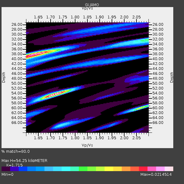
| Thickness Estimate: | 54 km |
| Thickness StdDev: | 9.2 km |
| Vp/Vs Estimate: | 1.72 |
| Vp/Vs StdDev: | 0.16 |
| Vs Estimate: | 3.847 km/s |
| Poisson's Ratio: | 0.24 |
| Peak Value: | 0.02 |
| Assumed Vp: | 6.597 km/s |
| Ps Weight: | 0.33333334 |
| PpPs Weight: | 0.33333334 |
| PsPs Weight: | 0.33333328 |
| Residual Complexity: | 0.847 |
| Nearby stations H: | +- |
| (2.0 deg) Vp/Vs: | +- |
1 with match > 90% ( 3.8461537 %) and 6 with match > 80% ( 23.076923 %) out of 26.
Download stack as xyz text file.
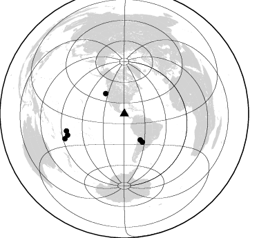
Azimuth Distribution of Events:
Prior Results for this Station
| Study | Thickness | Vp/Vs | Vp | Vs | Poissons Ratio | Extra |
| EARS | 54 km | 1.72 | 6.597 km/s | 3.847 km/s | 0.24 | |
| Crust2.0 | 40 km | 1.77 | 6.597 km/s | 3.723 km/s | 0.27 | L3,continental arc, Southern Andes, 0.2 km seds. |
| Global Maxima | 54 km | 1.72 | 6.597 km/s | 3.847 km/s | 0.24 | amp=0.0214514 |
| Local Maxima 1 | 38 km | 1.65 | 6.597 km/s | 3.986 km/s | 0.21 | amp=0.020824088 |
| Local Maxima 2 | 60 km | 2.06 | 6.597 km/s | 3.207 km/s | 0.35 | amp=0.013062718 |
| Local Maxima 3 | 32 km | 2.10 | 6.597 km/s | 3.149 km/s | 0.35 | amp=0.005745039 |
| Local Maxima 4 | 40 km | 1.60 | 6.597 km/s | 4.123 km/s | 0.18 | amp=0.0056507 |
| Predicted Arrivals for vertical incidence (zero ray parameter) | |
| Ps | 5.88 SECOND |
| PpPs | 22.32 SECOND |
| PsPs/PpSs | 28.20 SECOND |
Events Processed for this Station
Download zip of receiver functions as SAC
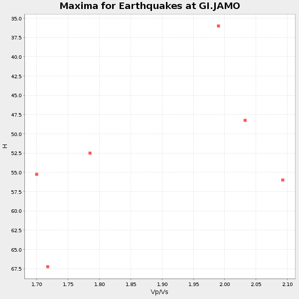
Plot maxima for each earthquake.
Events Used in the Stack
(6 events)| Radial Match | Distance | Baz | FERegion | Time | Lat/Lon | Depth | Magnitude |
| 93.22656 | 39.7 deg | 317.417 deg | Near Coast Of Northern Calif. | 2022/12/20 10:34:24 UTC | (40.5, -124.4) | 18 km | 6.4 mw |
| 87.630905 | 93.2 deg | 247.223 deg | South Of Fiji Islands | 2023/06/15 18:06:27 UTC | (-23.0, -177.2) | 167 km | 7.2 Mww |
| 84.93073 | 87.4 deg | 253.466 deg | Samoa Islands Region | 2022/12/04 19:24:15 UTC | (-15.4, -173.0) | 36 km | 6.7 Mww |
| 83.44371 | 48.5 deg | 147.448 deg | Santiago Del Estero Prov., Arg. | 2023/01/20 22:09:39 UTC | (-26.7, -63.0) | 611 km | 6.8 mww |
| 82.730286 | 87.6 deg | 249.486 deg | Tonga Islands Region | 2022/11/11 10:48:45 UTC | (-19.3, -172.1) | 25 km | 7.3 Mww |
| 80.15167 | 44.1 deg | 148.504 deg | Jujuy Province, Argentina | 2023/03/22 16:00:31 UTC | (-23.5, -66.5) | 210 km | 6.5 mww |
Losers
(20 events)| Radial Match | Distance | Baz | FERegion | Time | Lat/Lon | Depth | Magnitude | Reason |
| 79.59745 | 55.5 deg | 54.848 deg | Azores Islands Region | 2022/11/28 02:51:23 UTC | (37.1, -32.4) | 10 km | 5.9 mww | |
| 79.57024 | 53.8 deg | 164.142 deg | Near Coast Of Central Chile | 2022/11/13 02:24:57 UTC | (-37.5, -73.7) | 18 km | 6.2 mww | |
| 76.56427 | 43.2 deg | 300.737 deg | North Pacific Ocean | 2022/11/02 04:53:13 UTC | (31.5, -133.4) | 10 km | 6.0 mww | |
| 73.7316 | 89.3 deg | 44.719 deg | Central Italy | 2022/11/09 06:07:27 UTC | (43.9, 13.3) | 10 km | 5.6 mww | |
| 71.57447 | 79.7 deg | 320.702 deg | Rat Islands, Aleutian Islands | 2022/12/14 18:40:26 UTC | (51.6, 178.6) | 73 km | 6.3 Mww | |
| 70.59478 | 77.9 deg | 320.225 deg | Andreanof Islands, Aleutian Is. | 2023/06/13 16:16:02 UTC | (51.4, -178.4) | 16 km | 5.3 Mww | |
| 66.300644 | 87.3 deg | 253.636 deg | Tonga Islands | 2023/06/23 19:06:11 UTC | (-15.2, -173.0) | 10 km | 5.6 Mww | |
| 64.05771 | 97.7 deg | 205.782 deg | Pacific-Antarctic Ridge | 2022/11/14 15:01:52 UTC | (-64.0, -167.8) | 10 km | 5.6 Mwb | |
| 63.92891 | 45.5 deg | 156.259 deg | Near Coast Of Northern Chile | 2023/04/04 19:08:46 UTC | (-27.4, -71.0) | 51 km | 5.9 mww | |
| 63.271572 | 91.6 deg | 245.981 deg | Tonga Islands Region | 2023/06/16 19:10:52 UTC | (-23.8, -175.2) | 10 km | 6.5 Mi | |
| 63.259445 | 57.8 deg | 34.84 deg | Reykjanes Ridge | 2022/11/29 15:54:45 UTC | (53.8, -35.2) | 10 km | 5.5 Mww | |
| 63.156693 | 48.5 deg | 147.535 deg | Santiago Del Estero Prov., Arg. | 2023/01/24 18:37:00 UTC | (-26.7, -63.1) | 596 km | 6.4 mww | |
| 60.15275 | 92.2 deg | 246.35 deg | Tonga Islands Region | 2023/06/16 08:11:34 UTC | (-23.6, -175.9) | 22 km | 6.0 mww | |
| 59.811676 | 43.0 deg | 150.04 deg | Northern Chile | 2022/12/10 06:41:28 UTC | (-23.1, -68.1) | 114 km | 5.6 mww | |
| 58.247425 | 71.5 deg | 320.691 deg | Fox Islands, Aleutian Islands | 2022/11/21 15:09:29 UTC | (52.3, -168.1) | 0.8 km | 5.5 Mww | |
| 58.227646 | 93.5 deg | 250.257 deg | Fiji Islands Region | 2022/11/12 07:09:14 UTC | (-20.1, -178.4) | 587 km | 7.0 mww | |
| 55.412582 | 67.6 deg | 196.85 deg | Southern East Pacific Rise | 2023/01/11 16:17:45 UTC | (-49.9, -114.3) | 10 km | 6.0 Mww | |
| 54.208584 | 97.8 deg | 237.196 deg | South Of Kermadec Islands | 2022/12/20 16:38:41 UTC | (-33.8, -179.7) | 39 km | 5.6 Mww | |
| 52.296173 | 43.8 deg | 150.404 deg | Chile-Argentina Border Region | 2023/07/06 00:31:55 UTC | (-23.9, -67.9) | 132 km | 5.8 mww | |
| 40.439407 | 89.2 deg | 151.082 deg | South Sandwich Islands Region | 2023/01/03 21:52:09 UTC | (-57.8, -25.4) | 38 km | 5.3 Mww |

