
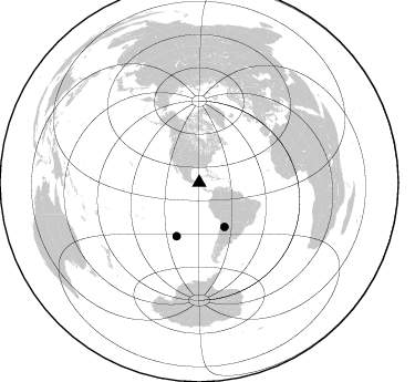
Station GI PETP - PETP
Network: GI - Red Sismologica Nacional- Guatemala
Nearby stations (2 deg radius)

| Station | Name | (Lat, Lon) | Start / End | Elevation |
| PETP | PETP | (16.33, -89.42) | 2014-01-01 / 2599-12-31 | 517 m |
| Crust2 Type: | L4,thin continental arc, Central America, 3.5 km seds. |
| Thickness Estimate: | 34 km |
| Thickness StdDev: | 7.8 km |
| Vp/Vs Estimate: | 1.88 |
| Vp/Vs StdDev: | 0.09 |
| Vs Estimate: | 3.347 km/s |
| Poisson's Ratio: | 0.30 |
| Peak Value: | 0.05 |
| Assumed Vp: | 6.302 km/s |
| Ps Weight: | 0.33333334 |
| PpPs Weight: | 0.33333334 |
| PsPs Weight: | 0.33333328 |
| Residual Complexity: | 0.739 |
| Nearby stations H: | +- |
| (2.0 deg) Vp/Vs: | +- |
1 with match > 90% ( 16.666666 %) and 2 with match > 80% ( 33.333332 %) out of 6.
Download stack as xyz text file.
Azimuth Distribution of Events:
Prior Results for this Station
| Study | Thickness | Vp/Vs | Vp | Vs | Poissons Ratio | Extra |
| EARS | 34 km | 1.88 | 6.302 km/s | 3.347 km/s | 0.30 | |
| Crust2.0 | 32 km | 1.78 | 6.302 km/s | 3.538 km/s | 0.27 | L4,thin continental arc, Central America, 3.5 km seds. |
| Global Maxima | 34 km | 1.88 | 6.302 km/s | 3.347 km/s | 0.30 | amp=0.051964622 |
| Local Maxima 1 | 39 km | 1.62 | 6.302 km/s | 3.89 km/s | 0.19 | amp=0.040551897 |
| Local Maxima 2 | 33 km | 1.72 | 6.302 km/s | 3.674 km/s | 0.24 | amp=0.031423282 |
| Local Maxima 3 | 59 km | 1.96 | 6.302 km/s | 3.211 km/s | 0.32 | amp=0.027514035 |
| Local Maxima 4 | 48 km | 1.61 | 6.302 km/s | 3.908 km/s | 0.19 | amp=0.020613978 |
| Predicted Arrivals for vertical incidence (zero ray parameter) | |
| Ps | 4.73 SECOND |
| PpPs | 15.44 SECOND |
| PsPs/PpSs | 20.16 SECOND |
Events Processed for this Station
Download zip of receiver functions as SAC
Plot maxima for each earthquake.
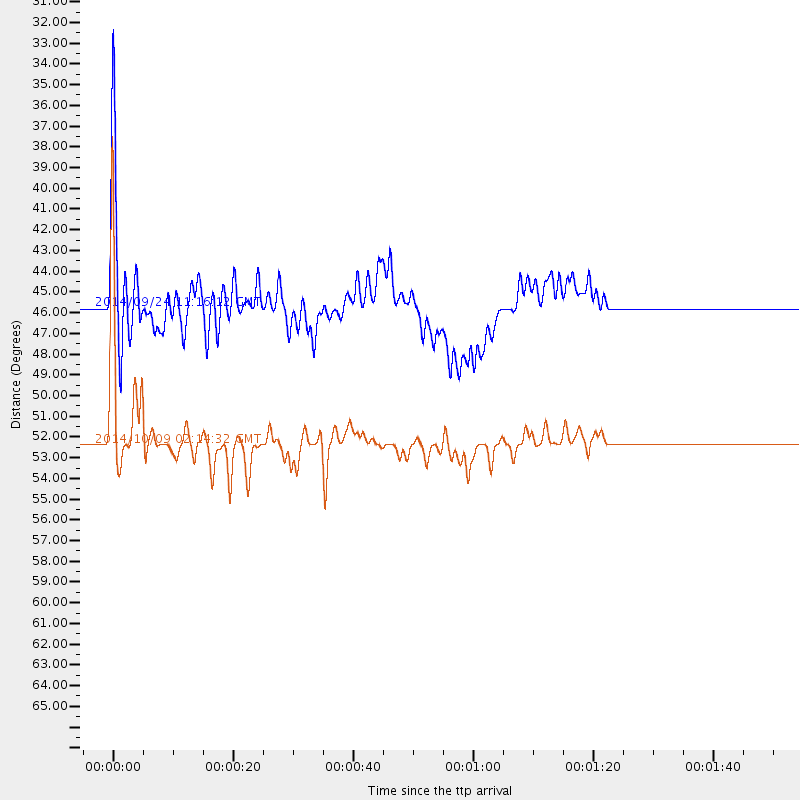
Events Used in the Stack
(2 events)| Radial Match | Distance | Baz | FERegion | Time | Lat/Lon | Depth | Magnitude |
| 92.60711 | 52.3 deg | 202.984 deg | Southern East Pacific Rise | 2014/10/09 02:14:32 GMT | (-32.1, -110.8) | 16 km | 7.1 MWW, 6.8 MI |
| 82.12607 | 45.8 deg | 150.226 deg | Jujuy Province, Argentina | 2014/09/24 11:16:12 GMT | (-23.9, -66.6) | 189 km | 6.2 MWP, 6.2 MWB, 6.2 MWC |
Losers
(4 events)| Radial Match | Distance | Baz | FERegion | Time | Lat/Lon | Depth | Magnitude | Reason |
| 73.24091 | 88.5 deg | 150.387 deg | South Sandwich Islands Region | 2014/09/22 16:01:42 GMT | (-56.0, -27.8) | 112 km | 5.6 MB, 5.7 MWB | |
| 71.21598 | 62.8 deg | 331.92 deg | Southern Alaska | 2014/09/25 17:51:17 GMT | (62.0, -151.8) | 103 km | 6.2 ML, 6.1 MI, 6.2 MWW, 6.3 MWR, 6.3 MWB, 6.3 MWC | |
| 67.63335 | 40.7 deg | 150.745 deg | Northern Chile | 2014/10/07 05:09:10 GMT | (-19.7, -69.7) | 103 km | 5.8 MB | |
| 33.77811 | 53.2 deg | 203.485 deg | Southern East Pacific Rise | 2014/10/09 08:14:23 GMT | (-32.7, -111.6) | 10 km | 5.6 MB |

