
Station GI SUCU - Cuyotenango, Suchitepequez
Network: GI - Red Sismologica Nacional- Guatemala
Nearby stations (2 deg radius)
| Station | Name | (Lat, Lon) | Start / End | Elevation |
| SUCU | Cuyotenango, Suchitepequez | (14.56, -91.56) | 2021-03-11 / 2499-01-01 | 444 m |
| Crust2 Type: | L8,thin continental arc, Cordilleras, 0.5 km seds. |
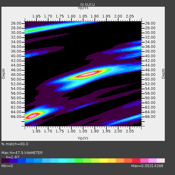
| Thickness Estimate: | 48 km |
| Thickness StdDev: | 8.7 km |
| Vp/Vs Estimate: | 1.87 |
| Vp/Vs StdDev: | 0.11 |
| Vs Estimate: | 3.511 km/s |
| Poisson's Ratio: | 0.30 |
| Peak Value: | 0.05 |
| Assumed Vp: | 6.566 km/s |
| Ps Weight: | 0.33333334 |
| PpPs Weight: | 0.33333334 |
| PsPs Weight: | 0.33333328 |
| Residual Complexity: | 0.678 |
| Nearby stations H: | +- |
| (2.0 deg) Vp/Vs: | +- |
3 with match > 90% ( 9.67742 %) and 5 with match > 80% ( 16.129032 %) out of 31.
Download stack as xyz text file.
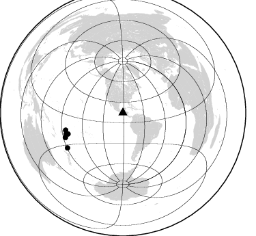
Azimuth Distribution of Events:
Prior Results for this Station
| Study | Thickness | Vp/Vs | Vp | Vs | Poissons Ratio | Extra |
| EARS | 48 km | 1.87 | 6.566 km/s | 3.511 km/s | 0.30 | |
| Crust2.0 | 34 km | 1.77 | 6.566 km/s | 3.707 km/s | 0.27 | L8,thin continental arc, Cordilleras, 0.5 km seds. |
| Global Maxima | 48 km | 1.87 | 6.566 km/s | 3.511 km/s | 0.30 | amp=0.05314269 |
| Local Maxima 1 | 66 km | 1.63 | 6.566 km/s | 4.022 km/s | 0.20 | amp=0.04923329 |
| Local Maxima 2 | 29 km | 1.61 | 6.566 km/s | 4.091 km/s | 0.18 | amp=0.026766494 |
| Local Maxima 3 | 64 km | 1.64 | 6.566 km/s | 4.01 km/s | 0.20 | amp=0.02269774 |
| Local Maxima 4 | 36 km | 2.10 | 6.566 km/s | 3.13 km/s | 0.35 | amp=0.01916851 |
| Predicted Arrivals for vertical incidence (zero ray parameter) | |
| Ps | 6.29 SECOND |
| PpPs | 20.76 SECOND |
| PsPs/PpSs | 27.06 SECOND |
Events Processed for this Station
Download zip of receiver functions as SAC
Plot maxima for each earthquake.
Events Used in the Stack
(5 events)| Radial Match | Distance | Baz | FERegion | Time | Lat/Lon | Depth | Magnitude |
| 92.38595 | 87.4 deg | 253.249 deg | Tonga Islands | 2023/05/10 16:02:00 UTC | (-15.6, -174.6) | 210 km | 7.6 mww |
| 92.161316 | 86.1 deg | 249.022 deg | Tonga Islands Region | 2022/11/11 10:48:45 UTC | (-19.3, -172.1) | 25 km | 7.3 Mww |
| 91.81783 | 91.7 deg | 246.824 deg | South Of Fiji Islands | 2023/06/15 18:06:27 UTC | (-23.0, -177.2) | 167 km | 7.2 Mww |
| 88.430954 | 88.6 deg | 249.701 deg | Tonga Islands | 2024/05/26 20:47:09 UTC | (-19.4, -174.9) | 112 km | 6.6 mww |
| 81.04 | 95.9 deg | 237.857 deg | South Of Kermadec Islands | 2023/09/08 09:09:58 UTC | (-32.7, -179.3) | 90 km | 6.6 mww |
Losers
(26 events)| Radial Match | Distance | Baz | FERegion | Time | Lat/Lon | Depth | Magnitude | Reason |
| 97.13922 | 56.1 deg | 159.939 deg | Southern Argentina | 2023/07/17 03:05:10 UTC | (-38.2, -70.4) | 171 km | 6.6 mww | |
| 89.55671 | 49.5 deg | 145.844 deg | Santiago Del Estero Prov., Arg. | 2023/01/20 22:09:39 UTC | (-26.7, -63.0) | 611 km | 6.8 mww | |
| 89.373405 | 48.6 deg | 156.734 deg | Near Coast Of Central Chile | 2023/09/06 23:48:05 UTC | (-30.3, -71.5) | 41 km | 6.2 mww | |
| 77.788025 | 94.7 deg | 240.912 deg | Kermadec Islands, New Zealand | 2023/03/04 06:41:22 UTC | (-29.5, -178.8) | 206 km | 6.9 mww | |
| 74.679596 | 45.1 deg | 146.685 deg | Jujuy Province, Argentina | 2023/03/22 16:00:31 UTC | (-23.5, -66.5) | 210 km | 6.5 mww | |
| 71.386086 | 78.6 deg | 320.512 deg | Rat Islands, Aleutian Islands | 2022/12/14 18:40:26 UTC | (51.6, 178.6) | 73 km | 6.3 Mww | |
| 70.425865 | 44.7 deg | 145.892 deg | Jujuy Province, Argentina | 2023/10/10 10:01:31 UTC | (-22.9, -66.2) | 247 km | 6.0 Mww | |
| 68.75056 | 40.2 deg | 145.973 deg | Northern Chile | 2023/12/02 07:55:40 UTC | (-19.2, -69.1) | 106 km | 5.8 Mww | |
| 66.95323 | 88.8 deg | 250.203 deg | Tonga Islands | 2024/01/18 22:12:20 UTC | (-18.9, -175.1) | 218 km | 6.4 Mww | |
| 66.62971 | 50.6 deg | 147.146 deg | Santiago Del Estero Prov., Arg. | 2023/08/05 07:20:07 UTC | (-28.2, -63.2) | 598 km | 6.2 Mww | |
| 66.443115 | 44.7 deg | 152.465 deg | Near Coast Of Northern Chile | 2023/05/07 06:29:00 UTC | (-25.4, -70.5) | 40 km | 5.2 Mww | |
| 64.820145 | 75.7 deg | 320.993 deg | Andreanof Islands, Aleutian Is. | 2023/10/16 11:35:31 UTC | (52.4, -176.9) | 187 km | 6.4 Mww | |
| 64.389046 | 76.2 deg | 201.285 deg | Pacific-Antarctic Ridge | 2024/05/14 15:07:59 UTC | (-54.9, -129.2) | 10 km | 5.5 Mwb | |
| 62.144783 | 41.7 deg | 301.185 deg | North Pacific Ocean | 2022/11/02 04:53:13 UTC | (31.5, -133.4) | 10 km | 6.0 mww | |
| 61.447773 | 51.3 deg | 160.391 deg | Off Coast Of Central Chile | 2023/02/23 10:23:38 UTC | (-33.9, -73.2) | 27 km | 5.5 Mww | |
| 61.065 | 49.5 deg | 145.929 deg | Santiago Del Estero Prov., Arg. | 2023/01/24 18:37:00 UTC | (-26.7, -63.1) | 596 km | 6.4 mww | |
| 60.716503 | 92.0 deg | 249.859 deg | Fiji Islands Region | 2022/11/12 07:09:14 UTC | (-20.1, -178.4) | 587 km | 7.0 mww | |
| 58.434063 | 88.3 deg | 149.31 deg | South Sandwich Islands Region | 2023/08/07 23:49:01 UTC | (-55.8, -27.1) | 16 km | 5.7 Mww | |
| 56.030743 | 45.9 deg | 154.945 deg | Near Coast Of Northern Chile | 2023/09/15 18:07:39 UTC | (-27.3, -71.6) | 4.9 km | 5.7 mww | |
| 55.358055 | 40.9 deg | 319.444 deg | Off Coast Of Oregon | 2024/03/27 03:23:04 UTC | (42.3, -126.6) | 10 km | 5.7 mww | |
| 53.216076 | 46.8 deg | 155.337 deg | Near Coast Of Central Chile | 2024/02/11 21:14:43 UTC | (-28.2, -71.4) | 34 km | 5.4 Mww | |
| 50.05373 | 78.7 deg | 321.014 deg | Rat Islands, Aleutian Islands | 2024/03/30 16:28:57 UTC | (52.1, 178.4) | 115 km | 5.8 mww | |
| 49.69981 | 46.7 deg | 143.875 deg | Salta Province, Argentina | 2023/10/10 00:13:15 UTC | (-23.6, -63.7) | 538 km | 5.6 Mww | |
| 48.94073 | 56.8 deg | 55.095 deg | Azores Islands Region | 2022/11/28 02:51:23 UTC | (37.1, -32.4) | 10 km | 5.9 mww | |
| 43.32799 | 47.4 deg | 62.797 deg | Northern Mid-Atlantic Ridge | 2024/03/14 21:10:25 UTC | (29.8, -42.7) | 10 km | 6.0 mww | |
| 35.724438 | 88.4 deg | 149.391 deg | South Sandwich Islands Region | 2024/05/02 06:36:32 UTC | (-55.9, -27.0) | 19 km | 5.4 Mwb |

