
Station GS CA01 - CA01, Fish Rocks
Network: GS - US Geological Survey Networks
Nearby stations (2 deg radius)
| Station | Name | (Lat, Lon) | Start / End | Elevation |
| CA01 | CA01, Fish Rocks | (35.67, -117.42) | 2019-07-07 / 2599-12-31 | 570 m |
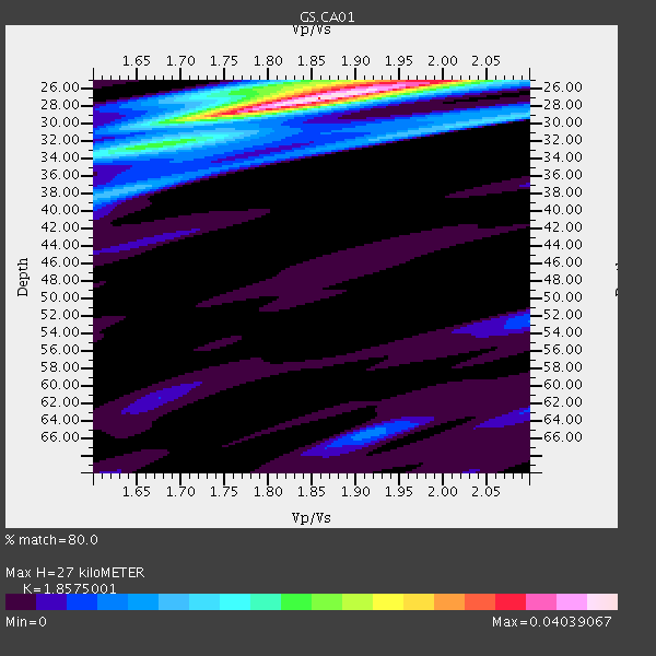
| Crust2 Type: | M5,extended crust, 0.5 km seds. |
| Thickness Estimate: | 27 km |
| Thickness StdDev: | 5.5 km |
| Vp/Vs Estimate: | 1.86 |
| Vp/Vs StdDev: | 0.05 |
| Vs Estimate: | 3.379 km/s |
| Poisson's Ratio: | 0.30 |
| Peak Value: | 0.04 |
| Assumed Vp: | 6.276 km/s |
| Ps Weight: | 0.33333334 |
| PpPs Weight: | 0.33333334 |
| PsPs Weight: | 0.33333328 |
| Residual Complexity: | 0.479 |
| Nearby stations H: | +- |
| (2.0 deg) Vp/Vs: | +- |
3 with match > 90% ( 18.75 %) and 5 with match > 80% ( 31.25 %) out of 16.
Download stack as xyz text file.
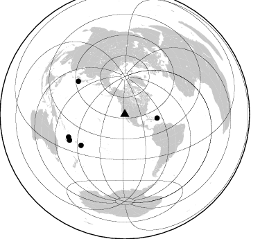
Azimuth Distribution of Events:
Prior Results for this Station
| Study | Thickness | Vp/Vs | Vp | Vs | Poissons Ratio | Extra |
| EARS | 27 km | 1.86 | 6.276 km/s | 3.379 km/s | 0.30 | |
| Crust2.0 | 31 km | 1.78 | 6.276 km/s | 3.529 km/s | 0.27 | M5,extended crust, 0.5 km seds. |
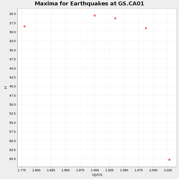
| Global Maxima | 27 km | 1.86 | 6.276 km/s | 3.379 km/s | 0.30 | amp=0.04039067 |
| Local Maxima 1 | 25 km | 1.95 | 6.276 km/s | 3.227 km/s | 0.32 | amp=0.020349745 |
| Local Maxima 2 | 33 km | 1.64 | 6.276 km/s | 3.827 km/s | 0.20 | amp=0.01667848 |
| Local Maxima 3 | 29 km | 2.08 | 6.276 km/s | 3.024 km/s | 0.35 | amp=0.012639345 |
| Local Maxima 4 | 26 km | 1.79 | 6.276 km/s | 3.511 km/s | 0.27 | amp=0.0109036155 |
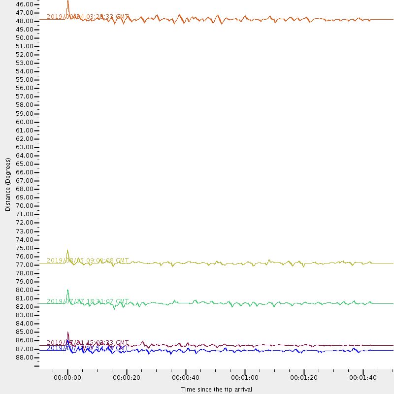
| Predicted Arrivals for vertical incidence (zero ray parameter) | |
| Ps | 3.69 SECOND |
| PpPs | 12.29 SECOND |
| PsPs/PpSs | 15.98 SECOND |
Events Processed for this Station
Download zip of receiver functions as SAC
Plot maxima for each earthquake.
Events Used in the Stack
(5 events)| Radial Match | Distance | Baz | FERegion | Time | Lat/Lon | Depth | Magnitude |
| 93.17476 | 87.3 deg | 248.066 deg | Vanuatu Islands | 2019/07/31 15:02:33 GMT | (-16.2, 167.9) | 179 km | 6.6 mww |
| 91.12231 | 82.2 deg | 305.213 deg | Near S. Coast Of Honshu, Japan | 2019/07/27 18:31:07 GMT | (33.1, 137.3) | 367 km | 6.3 Mww |
| 90.277435 | 77.2 deg | 234.722 deg | Tonga Islands | 2019/08/05 09:01:08 GMT | (-19.4, -174.9) | 10 km | 5.7 mb |
| 89.1736 | 88.0 deg | 244.929 deg | Vanuatu Islands | 2019/10/21 02:52:29 GMT | (-19.0, 169.5) | 226 km | 6.4 Mww |
| 84.06744 | 47.0 deg | 96.658 deg | Mona Passage | 2019/09/24 03:23:33 GMT | (19.2, -67.2) | 10 km | 6.3 Mi |
Losers
(11 events)| Radial Match | Distance | Baz | FERegion | Time | Lat/Lon | Depth | Magnitude | Reason |
| 78.58359 | 62.6 deg | 79.378 deg | Northern Mid-Atlantic Ridge | 2019/09/02 22:45:48 GMT | (23.8, -45.2) | 10 km | 5.9 Mww | |
| 74.4505 | 77.1 deg | 237.869 deg | Fiji Islands Region | 2019/07/17 02:43:24 GMT | (-17.1, -177.1) | 10 km | 5.6 Mwb | |
| 69.12 | 86.8 deg | 249.971 deg | Vanuatu Islands | 2019/08/24 15:51:27 GMT | (-14.3, 167.2) | 115 km | 6.0 Mww | |
| 68.988434 | 72.5 deg | 167.614 deg | Southeast Of Easter Island | 2019/09/27 15:11:29 GMT | (-35.9, -102.8) | 10 km | 5.6 mb | |
| 62.082012 | 75.1 deg | 309.661 deg | Near East Coast Of Honshu, Japan | 2019/08/15 05:32:53 GMT | (40.8, 141.2) | 86 km | 5.4 Mww | |
| 60.065235 | 85.8 deg | 251.417 deg | Santa Cruz Islands | 2019/08/22 22:54:26 GMT | (-12.6, 167.0) | 213 km | 5.6 Mww | |
| 58.15684 | 89.4 deg | 284.691 deg | South Of Mariana Islands | 2019/07/21 17:25:14 GMT | (12.3, 144.4) | 10 km | 5.5 Mww | |
| 55.78976 | 86.7 deg | 147.301 deg | Central Chile | 2019/09/26 16:36:18 GMT | (-40.8, -72.2) | 130 km | 6.1 Mww | |
| 55.3328 | 90.6 deg | 307.35 deg | Northwest Of Ryukyu Islands | 2019/07/13 00:57:44 GMT | (29.4, 128.2) | 251 km | 6.1 Mww | |
| 51.043915 | 90.2 deg | 227.366 deg | South Of Kermadec Islands | 2019/07/23 23:08:52 GMT | (-33.8, -179.5) | 10 km | 5.5 Mww | |
| 50.41393 | 75.6 deg | 239.722 deg | Fiji Islands Region | 2019/08/22 19:27:12 GMT | (-14.8, -177.3) | 10 km | 5.8 Mww |

