
Station GS ETX06 - Rte 59 and Co Rd 4763, Timpson, TX, USA
Network: GS - US Geological Survey Networks
Nearby stations (2 deg radius)
| Station | Name | (Lat, Lon) | Start / End | Elevation |
| ETX06 | Rte 59 and Co Rd 4763, Timpson, TX, USA | (31.87, -94.45) | 2013-02-21 / 2013-07-27 | 117 m |
| Crust2 Type: | C8,continental shelf, 10 km seds. |
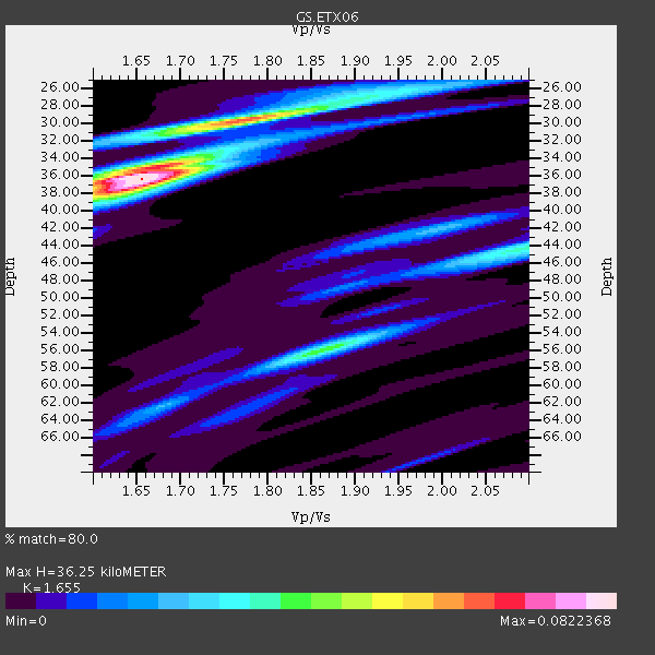
| Thickness Estimate: | 36 km |
| Thickness StdDev: | 3.0 km |
| Vp/Vs Estimate: | 1.65 |
| Vp/Vs StdDev: | 0.07 |
| Vs Estimate: | 3.467 km/s |
| Poisson's Ratio: | 0.21 |
| Peak Value: | 0.08 |
| Assumed Vp: | 5.738 km/s |
| Ps Weight: | 0.33333334 |
| PpPs Weight: | 0.33333334 |
| PsPs Weight: | 0.33333328 |
| Residual Complexity: | 0.665 |
| Nearby stations H: | +- |
| (2.0 deg) Vp/Vs: | +- |
2 with match > 90% ( 33.333332 %) and 3 with match > 80% ( 50.0 %) out of 6.
Download stack as xyz text file.
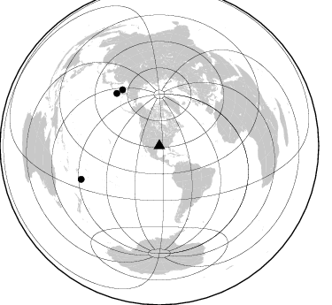
Azimuth Distribution of Events:
Prior Results for this Station
| Study | Thickness | Vp/Vs | Vp | Vs | Poissons Ratio | Extra |
| EARS | 36 km | 1.65 | 5.738 km/s | 3.467 km/s | 0.21 | |
| Crust2.0 | 32 km | 1.81 | 5.738 km/s | 3.178 km/s | 0.28 | C8,continental shelf, 10 km seds. |
| Global Maxima | 36 km | 1.65 | 5.738 km/s | 3.467 km/s | 0.21 | amp=0.0822368 |
| Local Maxima 1 | 29 km | 1.79 | 5.738 km/s | 3.206 km/s | 0.27 | amp=0.049428757 |
| Local Maxima 2 | 56 km | 1.87 | 5.738 km/s | 3.077 km/s | 0.30 | amp=0.040336415 |
| Local Maxima 3 | 38 km | 1.62 | 5.738 km/s | 3.531 km/s | 0.20 | amp=0.03334436 |
| Local Maxima 4 | 35 km | 1.68 | 5.738 km/s | 3.426 km/s | 0.22 | amp=0.027768038 |
| Predicted Arrivals for vertical incidence (zero ray parameter) | |
| Ps | 4.14 SECOND |
| PpPs | 16.77 SECOND |
| PsPs/PpSs | 20.91 SECOND |
Events Processed for this Station
Download zip of receiver functions as SAC
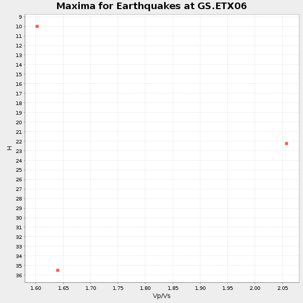
Plot maxima for each earthquake.
Events Used in the Stack
(3 events)| Radial Match | Distance | Baz | FERegion | Time | Lat/Lon | Depth | Magnitude |
| 97.81053 | 76.0 deg | 326.579 deg | Sea Of Okhotsk | 2013/05/24 05:44:48 GMT | (54.9, 153.2) | 598 km | 8.4 MW, 7.5 MB, 8.3 MW |
| 93.30349 | 96.1 deg | 246.813 deg | South Of Fiji Islands | 2013/05/23 17:19:04 GMT | (-23.0, -177.2) | 174 km | 7.4 MW, 6.6 MB, 7.4 MW |
| 85.8258 | 76.6 deg | 320.815 deg | East Of Kuril Islands | 2013/04/19 19:58:40 GMT | (50.0, 157.7) | 15 km | 6.1 MW, 5.9 MB, 6.0 MW, 6.1 MS |
Losers
(3 events)| Radial Match | Distance | Baz | FERegion | Time | Lat/Lon | Depth | Magnitude | Reason |
| 74.81919 | 76.8 deg | 321.115 deg | Kuril Islands | 2013/04/20 13:12:50 GMT | (50.1, 157.1) | 18 km | 6.1 MW, 5.8 MB, 5.9 MS, 6.0 MW | |
| 48.198025 | 93.5 deg | 203.104 deg | Pacific-Antarctic Ridge | 2013/05/04 23:39:04 GMT | (-54.6, -136.7) | 10 km | 5.5 MW | |
| 39.465603 | 77.4 deg | 170.057 deg | Off Coast Of Southern Chile | 2013/05/20 09:49:04 GMT | (-44.9, -80.7) | 10 km | 6.4 MW, 5.5 MB, 5.8 MS, 6.3 MW |
