
Station GS ID09 - Alton, Idaho, USA
Network: GS - US Geological Survey Networks
Nearby stations (2 deg radius)
| Station | Name | (Lat, Lon) | Start / End | Elevation |
| ID09 | Alton, Idaho, USA | (42.24, -111.19) | 2017-09-09 / 2599-12-31 | 2088 m |
| Crust2 Type: | M8,thick extended crust, 1.5 km seds. |
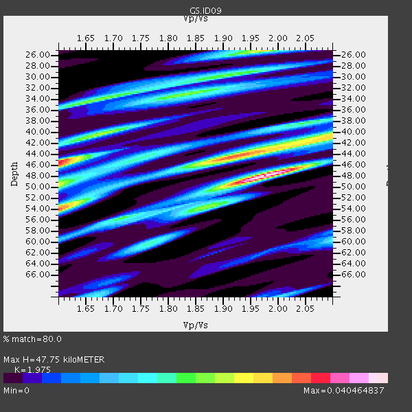
| Thickness Estimate: | 48 km |
| Thickness StdDev: | 15 km |
| Vp/Vs Estimate: | 1.98 |
| Vp/Vs StdDev: | 0.01 |
| Vs Estimate: | 3.143 km/s |
| Poisson's Ratio: | 0.33 |
| Peak Value: | 0.04 |
| Assumed Vp: | 6.207 km/s |
| Ps Weight: | 0.33333334 |
| PpPs Weight: | 0.33333334 |
| PsPs Weight: | 0.33333328 |
| Residual Complexity: | 0.865 |
| Nearby stations H: | +- |
| (2.0 deg) Vp/Vs: | +- |
0 with match > 90% ( 0.0 %) and 2 with match > 80% ( 10.0 %) out of 20.
Download stack as xyz text file.
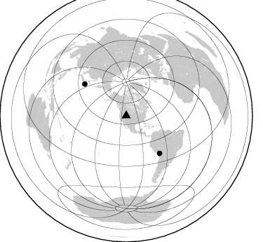
Azimuth Distribution of Events:
Prior Results for this Station
| Study | Thickness | Vp/Vs | Vp | Vs | Poissons Ratio | Extra |
| EARS | 48 km | 1.98 | 6.207 km/s | 3.143 km/s | 0.33 | |
| Crust2.0 | 37 km | 1.78 | 6.207 km/s | 3.489 km/s | 0.27 | M8,thick extended crust, 1.5 km seds. |
| Global Maxima | 48 km | 1.98 | 6.207 km/s | 3.143 km/s | 0.33 | amp=0.040464837 |
| Local Maxima 1 | 45 km | 1.60 | 6.207 km/s | 3.879 km/s | 0.18 | amp=0.033833116 |
| Local Maxima 2 | 44 km | 1.92 | 6.207 km/s | 3.237 km/s | 0.31 | amp=0.031605937 |
| Local Maxima 3 | 25 km | 1.97 | 6.207 km/s | 3.147 km/s | 0.33 | amp=0.027660113 |
| Local Maxima 4 | 54 km | 1.60 | 6.207 km/s | 3.873 km/s | 0.18 | amp=0.0270522 |
| Predicted Arrivals for vertical incidence (zero ray parameter) | |
| Ps | 7.50 SECOND |
| PpPs | 22.89 SECOND |
| PsPs/PpSs | 30.39 SECOND |
Events Processed for this Station
Download zip of receiver functions as SAC
Plot maxima for each earthquake.
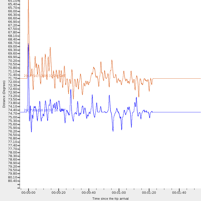
Events Used in the Stack
(2 events)| Radial Match | Distance | Baz | FERegion | Time | Lat/Lon | Depth | Magnitude |
| 83.05258 | 74.5 deg | 307.327 deg | Off East Coast Of Honshu, Japan | 2017/09/20 16:37:16 GMT | (38.0, 144.7) | 10 km | 6.1 Mww |
| 82.83178 | 71.6 deg | 138.447 deg | Northern Chile | 2017/10/10 06:32:20 GMT | (-18.5, -69.6) | 82 km | 6.3 Mww |
Losers
(18 events)| Radial Match | Distance | Baz | FERegion | Time | Lat/Lon | Depth | Magnitude | Reason |
| 77.11167 | 75.3 deg | 307.337 deg | Off East Coast Of Honshu, Japan | 2017/10/06 07:59:33 GMT | (37.5, 144.0) | 10 km | 6.0 Mww | |
| 75.78208 | 31.0 deg | 146.4 deg | Off Coast Of Chiapas, Mexico | 2017/09/29 04:00:22 GMT | (14.9, -94.0) | 22 km | 5.6 mb | |
| 70.457344 | 30.6 deg | 146.134 deg | Near Coast Of Oaxaca, Mexico | 2017/09/24 10:06:12 GMT | (15.3, -94.1) | 55 km | 5.8 Mww | |
| 69.37423 | 30.5 deg | 146.988 deg | Near Coast Of Oaxaca, Mexico | 2017/09/18 14:19:12 GMT | (15.3, -94.6) | 10 km | 5.6 Mww | |
| 59.225246 | 89.3 deg | 236.688 deg | South Of Fiji Islands | 2017/09/26 04:20:00 GMT | (-23.7, -176.9) | 98 km | 6.4 mww | |
| 58.127583 | 30.2 deg | 145.934 deg | Near Coast Of Oaxaca, Mexico | 2017/09/23 10:38:08 GMT | (15.7, -94.2) | 74 km | 5.8 Mww | |
| 55.06266 | 68.9 deg | 138.682 deg | Southern Peru | 2017/09/20 05:26:08 GMT | (-16.3, -71.3) | 93 km | 5.3 Mww | |
| 54.308582 | 95.1 deg | 249.357 deg | Vanuatu Islands | 2017/09/20 20:09:49 GMT | (-18.8, 169.1) | 200 km | 6.4 mww | |
| 51.12018 | 82.0 deg | 147.21 deg | Off Coast Of Central Chile | 2017/09/18 13:46:56 GMT | (-31.8, -72.1) | 10 km | 5.8 Mww | |
| 49.04829 | 49.5 deg | 44.415 deg | Reykjanes Ridge | 2017/09/10 21:40:21 GMT | (57.1, -33.7) | 10 km | 5.9 Mww | |
| 47.849968 | 94.9 deg | 349.086 deg | Northern Xinjiang, China | 2017/09/16 10:11:33 GMT | (42.2, 83.5) | 16 km | 5.4 Mww | |
| 45.370106 | 86.9 deg | 292.363 deg | Mariana Islands | 2017/09/14 17:41:28 GMT | (18.7, 145.7) | 173 km | 5.8 mww | |
| 44.630264 | 74.3 deg | 310.353 deg | Near East Coast Of Honshu, Japan | 2017/09/26 20:22:11 GMT | (40.3, 142.4) | 36 km | 5.8 Mww | |
| 39.867447 | 85.5 deg | 298.355 deg | Volcano Islands, Japan Region | 2017/09/11 17:35:09 GMT | (24.0, 142.3) | 35 km | 5.7 Mww | |
| 38.40091 | 85.0 deg | 238.895 deg | Tonga Islands | 2017/10/08 14:04:38 GMT | (-19.0, -175.6) | 10 km | 6.1 Mww | |
| 37.71746 | 75.4 deg | 139.652 deg | Northern Chile | 2017/10/05 08:11:36 GMT | (-22.4, -68.6) | 113 km | 5.4 Mww | |
| 36.297367 | 31.1 deg | 146.254 deg | Near Coast Of Chiapas, Mexico | 2017/09/11 21:09:10 GMT | (14.9, -93.9) | 27 km | 5.5 Mww | |
| 27.175955 | 60.3 deg | 98.976 deg | North Atlantic Ocean | 2017/10/03 20:39:04 GMT | (13.5, -49.3) | 10 km | 5.7 Mww |

