
Station GS MHTCO - 25601 Hwy 12, Trinidad, CO, USA
Network: GS - US Geological Survey Networks
Nearby stations (2 deg radius)
| Station | Name | (Lat, Lon) | Start / End | Elevation |
| MHTCO | 25601 Hwy 12, Trinidad, CO, USA | (37.13, -104.69) | 2011-08-23 / 2999-12-31 | 1978 m |
| Crust2 Type: | PC,orogen/45km, Orogen, 1 km seds. |
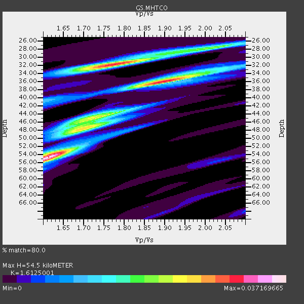
| Thickness Estimate: | 54 km |
| Thickness StdDev: | 5.3 km |
| Vp/Vs Estimate: | 1.61 |
| Vp/Vs StdDev: | 0.09 |
| Vs Estimate: | 3.917 km/s |
| Poisson's Ratio: | 0.19 |
| Peak Value: | 0.04 |
| Assumed Vp: | 6.316 km/s |
| Ps Weight: | 0.33333334 |
| PpPs Weight: | 0.33333334 |
| PsPs Weight: | 0.33333328 |
| Residual Complexity: | 0.847 |
| Nearby stations H: | +- |
| (2.0 deg) Vp/Vs: | +- |
1 with match > 90% ( 16.666666 %) and 3 with match > 80% ( 50.0 %) out of 6.
Download stack as xyz text file.
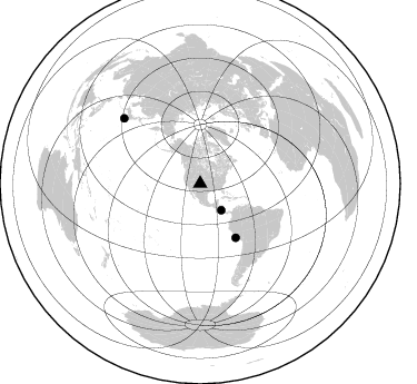
Azimuth Distribution of Events:
Prior Results for this Station
| Study | Thickness | Vp/Vs | Vp | Vs | Poissons Ratio | Extra |
| EARS | 54 km | 1.61 | 6.316 km/s | 3.917 km/s | 0.19 | |
| Crust2.0 | 45 km | 1.76 | 6.316 km/s | 3.587 km/s | 0.26 | PC,orogen/45km, Orogen, 1 km seds. |
| Global Maxima | 54 km | 1.61 | 6.316 km/s | 3.917 km/s | 0.19 | amp=0.037169665 |
| Local Maxima 1 | 32 km | 1.77 | 6.316 km/s | 3.568 km/s | 0.27 | amp=0.0307707 |
| Local Maxima 2 | 36 km | 1.89 | 6.316 km/s | 3.337 km/s | 0.31 | amp=0.029431071 |
| Local Maxima 3 | 47 km | 1.71 | 6.316 km/s | 3.693 km/s | 0.24 | amp=0.02012627 |
| Local Maxima 4 | 27 km | 2.04 | 6.316 km/s | 3.1 km/s | 0.34 | amp=0.0174366 |
| Predicted Arrivals for vertical incidence (zero ray parameter) | |
| Ps | 5.29 SECOND |
| PpPs | 22.54 SECOND |
| PsPs/PpSs | 27.83 SECOND |
Events Processed for this Station
Download zip of receiver functions as SAC
Plot maxima for each earthquake.
Events Used in the Stack
(3 events)| Radial Match | Distance | Baz | FERegion | Time | Lat/Lon | Depth | Magnitude |
| 92.13334 | 58.0 deg | 146.693 deg | Near Coast Of Peru | 2011/10/28 18:54:34 GMT | (-14.4, -76.0) | 24 km | 6.5 MB, 6.9 MS, 6.9 MW, 6.9 MW |
| 82.58427 | 30.6 deg | 141.548 deg | Nicaragua | 2011/11/07 22:35:25 GMT | (11.6, -85.9) | 177 km | 6.0 MB, 6.0 MW, 6.1 MW |
| 81.411255 | 90.0 deg | 310.55 deg | Southeast Of Honshu, Japan | 2012/01/01 05:27:55 GMT | (31.5, 138.1) | 365 km | 6.2 MB, 6.8 MW, 6.8 MW |
Losers
(3 events)| Radial Match | Distance | Baz | FERegion | Time | Lat/Lon | Depth | Magnitude | Reason |
| 79.78912 | 44.2 deg | 145.701 deg | Off Coast Of Ecuador | 2011/11/17 01:57:05 GMT | (-1.7, -81.5) | 27 km | 5.7 MB, 5.6 MS, 6.0 MW, 5.9 MW | |
| 65.31687 | 48.3 deg | 310.552 deg | Fox Islands, Aleutian Islands | 2011/10/25 03:24:49 GMT | (52.2, -171.8) | 38 km | 5.9 MB, 5.3 MS, 5.7 MW, 5.7 MW | |
| 46.39943 | 94.3 deg | 190.978 deg | Southern East Pacific Rise | 2011/11/11 10:41:37 GMT | (-56.0, -124.4) | 10 km | 5.6 MS, 5.1 MB, 6.0 MW, 6.1 MW |
