
Station GS OK022 - S3560 Rd, Prague, Oklahoma, USA
Network: GS - US Geological Survey Networks
Nearby stations (2 deg radius)
| Station | Name | (Lat, Lon) | Start / End | Elevation |
| OK022 | S3560 Rd, Prague, Oklahoma, USA | (35.54, -96.66) | 2011-11-09 / 2999-12-31 | 272 m |
| Crust2 Type: | D8,thick Platform 3 km seds. |
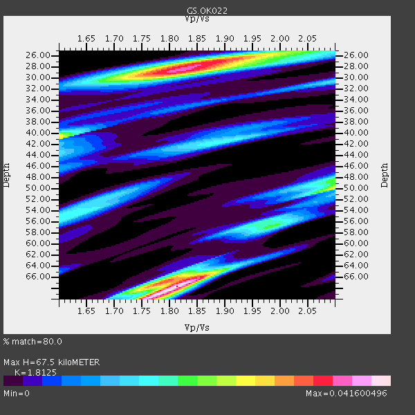
| Thickness Estimate: | 68 km |
| Thickness StdDev: | 6.3 km |
| Vp/Vs Estimate: | 1.81 |
| Vp/Vs StdDev: | 0.08 |
| Vs Estimate: | 3.545 km/s |
| Poisson's Ratio: | 0.28 |
| Peak Value: | 0.04 |
| Assumed Vp: | 6.426 km/s |
| Ps Weight: | 0.33333334 |
| PpPs Weight: | 0.33333334 |
| PsPs Weight: | 0.33333328 |
| Residual Complexity: | 0.861 |
| Nearby stations H: | +- |
| (2.0 deg) Vp/Vs: | +- |
0 with match > 90% ( 0.0 %) and 2 with match > 80% ( 20.0 %) out of 10.
Download stack as xyz text file.
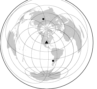
Azimuth Distribution of Events:
Prior Results for this Station
| Study | Thickness | Vp/Vs | Vp | Vs | Poissons Ratio | Extra |
| EARS | 68 km | 1.81 | 6.426 km/s | 3.545 km/s | 0.28 | |
| Crust2.0 | 46 km | 1.78 | 6.426 km/s | 3.613 km/s | 0.27 | D8,thick Platform 3 km seds. |
| Global Maxima | 68 km | 1.81 | 6.426 km/s | 3.545 km/s | 0.28 | amp=0.041600496 |
| Local Maxima 1 | 28 km | 1.81 | 6.426 km/s | 3.545 km/s | 0.28 | amp=0.035983905 |
| Local Maxima 2 | 41 km | 1.60 | 6.426 km/s | 4.016 km/s | 0.18 | amp=0.02764569 |
| Local Maxima 3 | 67 km | 1.77 | 6.426 km/s | 3.62 km/s | 0.27 | amp=0.026889395 |
| Local Maxima 4 | 50 km | 2.10 | 6.426 km/s | 3.064 km/s | 0.35 | amp=0.024070894 |
| Predicted Arrivals for vertical incidence (zero ray parameter) | |
| Ps | 8.53 SECOND |
| PpPs | 29.54 SECOND |
| PsPs/PpSs | 38.08 SECOND |
Events Processed for this Station
Download zip of receiver functions as SAC
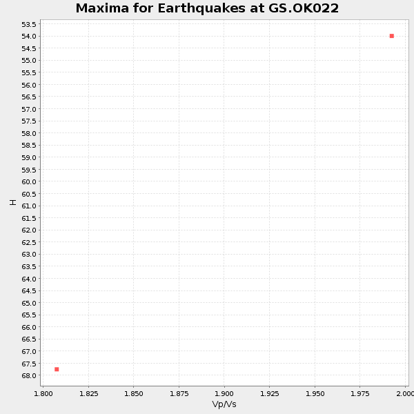
Plot maxima for each earthquake.
Events Used in the Stack
(2 events)| Radial Match | Distance | Baz | FERegion | Time | Lat/Lon | Depth | Magnitude |
| 85.098045 | 92.4 deg | 352.158 deg | Southwestern Siberia, Russia | 2012/02/26 06:17:19 GMT | (51.7, 96.0) | 12 km | 6.4 MB, 6.6 MS, 6.7 MW, 6.5 MW |
| 80.0023 | 74.9 deg | 160.427 deg | Near Coast Of Central Chile | 2012/01/23 16:04:52 GMT | (-36.4, -73.0) | 20 km | 5.8 MB, 6.0 MS, 6.1 MW, 6.2 MW |
Losers
(8 events)| Radial Match | Distance | Baz | FERegion | Time | Lat/Lon | Depth | Magnitude | Reason |
| 70.65059 | 58.8 deg | 143.806 deg | Central Bolivia | 2011/11/22 18:48:16 GMT | (-15.4, -65.1) | 550 km | 6.2 MB, 6.6 MW, 6.6 MW | |
| 70.230705 | 39.7 deg | 155.886 deg | Off Coast Of Ecuador | 2011/11/17 01:57:05 GMT | (-1.7, -81.5) | 27 km | 5.7 MB, 5.6 MS, 6.0 MW, 5.9 MW | |
| 61.612434 | 85.7 deg | 319.93 deg | Hokkaido, Japan Region | 2011/11/24 10:25:34 GMT | (41.9, 142.6) | 38 km | 5.9 MB, 5.8 MS, 6.2 MW, 6.2 MW | |
| 58.63121 | 91.4 deg | 316.196 deg | Near East Coast Of Honshu, Japan | 2012/02/29 14:32:47 GMT | (35.2, 141.0) | 26 km | 5.6 MB, 5.5 MS, 5.6 MW, 5.7 MW | |
| 54.997276 | 93.9 deg | 250.817 deg | Fiji Islands Region | 2012/02/10 01:47:34 GMT | (-18.0, -178.5) | 582 km | 6.0 MB, 5.9 MW, 6.0 MW | |
| 50.770542 | 94.2 deg | 195.225 deg | Southern East Pacific Rise | 2011/11/11 10:41:37 GMT | (-56.0, -124.4) | 10 km | 5.6 MS, 5.1 MB, 6.0 MW, 6.1 MW | |
| 33.92917 | 89.7 deg | 317.473 deg | Near East Coast Of Honshu, Japan | 2011/11/23 19:24:31 GMT | (37.4, 141.4) | 34 km | 5.7 MB, 5.8 MS, 6.1 MW, 6.1 MW | |
| 31.117752 | 89.2 deg | 249.553 deg | Tonga Islands | 2011/12/26 04:48:08 GMT | (-16.2, -173.9) | 90 km | 5.8 MB, 6.0 MW, 6.0 MW |
