
Station GS OK037 - N2390 and E0350 Rds, Waynoka, OK, USA
Network: GS - US Geological Survey Networks
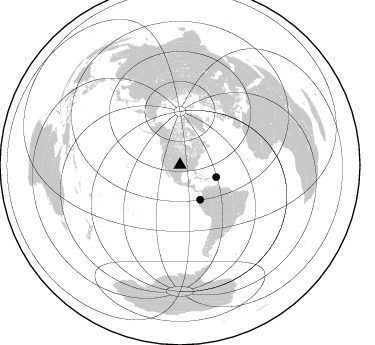
Nearby stations (2 deg radius)
| Station | Name | (Lat, Lon) | Start / End | Elevation |
| OK037 | N2390 and E0350 Rds, Waynoka, OK, USA | (36.51, -98.74) | 2016-02-16 / 2599-12-31 | 468 m |
| Crust2 Type: | D8,thick Platform 3 km seds. |
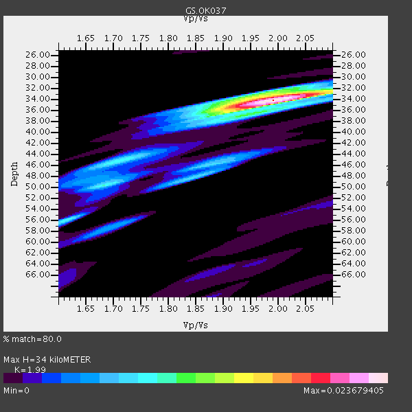
| Thickness Estimate: | 34 km |
| Thickness StdDev: | 10 km |
| Vp/Vs Estimate: | 1.99 |
| Vp/Vs StdDev: | 0.05 |
| Vs Estimate: | 3.229 km/s |
| Poisson's Ratio: | 0.33 |
| Peak Value: | 0.02 |
| Assumed Vp: | 6.426 km/s |
| Ps Weight: | 0.33333334 |
| PpPs Weight: | 0.33333334 |
| PsPs Weight: | 0.33333328 |
| Residual Complexity: | 0.445 |
| Nearby stations H: | +- |
| (2.0 deg) Vp/Vs: | +- |
2 with match > 90% ( 28.571428 %) and 2 with match > 80% ( 28.571428 %) out of 7.
Download stack as xyz text file.
Azimuth Distribution of Events:
Prior Results for this Station
| Study | Thickness | Vp/Vs | Vp | Vs | Poissons Ratio | Extra |
| EARS | 34 km | 1.99 | 6.426 km/s | 3.229 km/s | 0.33 | |
| Crust2.0 | 46 km | 1.78 | 6.426 km/s | 3.613 km/s | 0.27 | D8,thick Platform 3 km seds. |
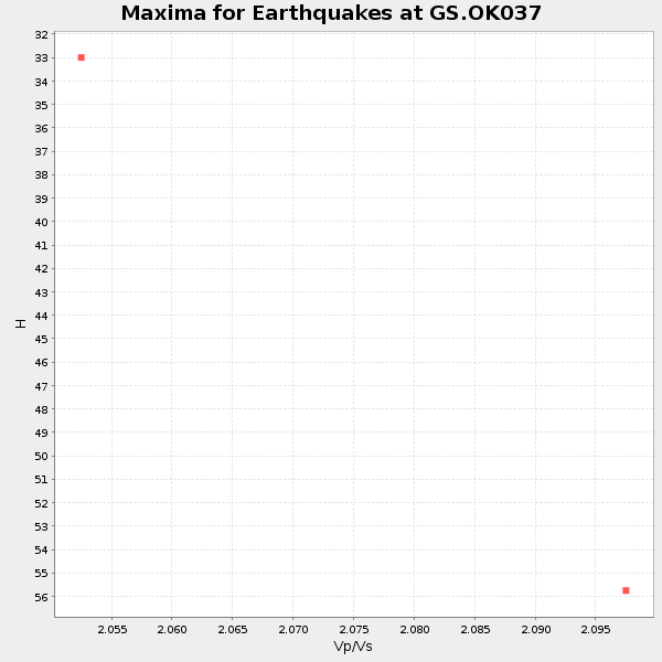
| Global Maxima | 34 km | 1.99 | 6.426 km/s | 3.229 km/s | 0.33 | amp=0.023679405 |
| Local Maxima 1 | 50 km | 1.68 | 6.426 km/s | 3.825 km/s | 0.23 | amp=0.008889987 |
| Local Maxima 2 | 33 km | 1.97 | 6.426 km/s | 3.27 km/s | 0.33 | amp=0.008212833 |
| Local Maxima 3 | 48 km | 1.85 | 6.426 km/s | 3.478 km/s | 0.29 | amp=0.0072733713 |
| Local Maxima 4 | 46 km | 1.69 | 6.426 km/s | 3.802 km/s | 0.23 | amp=0.006553881 |
| Predicted Arrivals for vertical incidence (zero ray parameter) | |
| Ps | 5.24 SECOND |
| PpPs | 15.82 SECOND |
| PsPs/PpSs | 21.06 SECOND |
Events Processed for this Station
Download zip of receiver functions as SAC
Plot maxima for each earthquake.
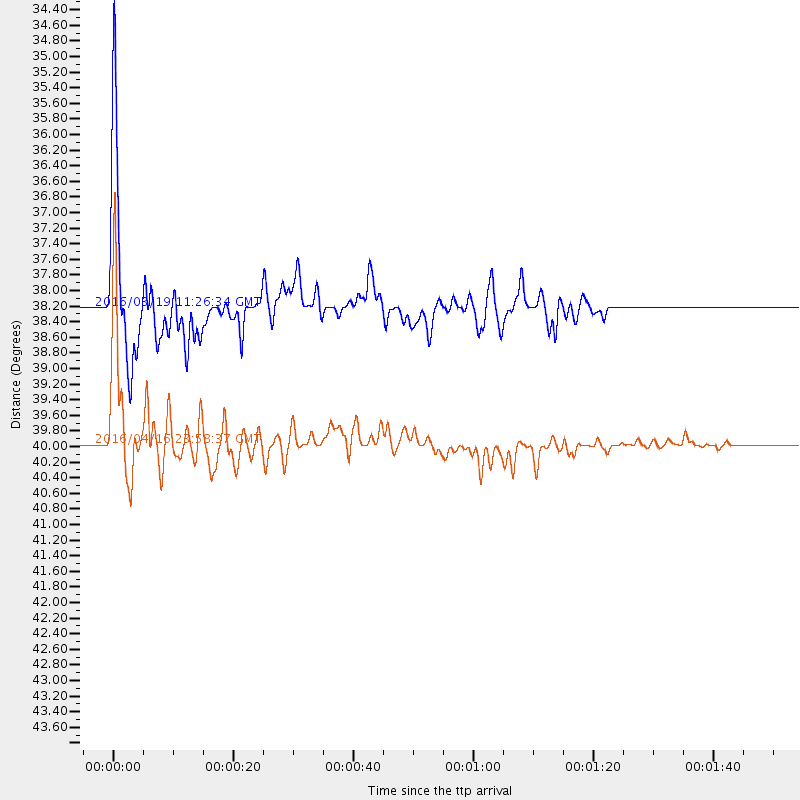
Events Used in the Stack
(2 events)| Radial Match | Distance | Baz | FERegion | Time | Lat/Lon | Depth | Magnitude |
| 96.89778 | 40.0 deg | 149.877 deg | Near Coast Of Ecuador | 2016/04/16 23:58:37 GMT | (0.4, -79.9) | 19 km | 7.8 MWW, 7.4 MI |
| 90.54116 | 38.2 deg | 108.534 deg | Leeward Islands | 2016/03/19 11:26:34 GMT | (18.0, -60.7) | 32 km | 6.0 MWW, 5.9 MWB |
Losers
(5 events)| Radial Match | Distance | Baz | FERegion | Time | Lat/Lon | Depth | Magnitude | Reason |
| 71.360565 | 39.6 deg | 150.205 deg | Near Coast Of Ecuador | 2016/04/23 01:24:34 GMT | (0.6, -80.3) | 10 km | 5.8 MWP | |
| 60.869854 | 88.5 deg | 246.742 deg | Tonga Islands | 2016/04/24 22:24:36 GMT | (-17.7, -173.2) | 27 km | 5.7 MWW, 5.6 MWB, 5.7 MWC | |
| 54.090923 | 44.8 deg | 109.952 deg | North Atlantic Ocean | 2016/04/20 10:51:39 GMT | (13.2, -55.9) | 10 km | 5.8 MB | |
| 42.339382 | 87.0 deg | 248.846 deg | Tonga Islands | 2016/03/08 05:36:27 GMT | (-15.1, -173.4) | 30 km | 5.8 MB | |
| 33.57108 | 97.1 deg | 319.796 deg | Kyushu, Japan | 2016/04/15 16:44:06 GMT | (32.7, 130.7) | 10 km | 5.8 MB |

