
Station GS OK050 - Pawnee, OK, Station 50
Network: GS - US Geological Survey Networks
Nearby stations (2 deg radius)
| Station | Name | (Lat, Lon) | Start / End | Elevation |
| OK050 | Pawnee, OK, Station 50 | (36.39, -96.98) | 2016-09-10 / 2599-12-31 | 315 m |
| Crust2 Type: | D5,thick Platform 2 km seds. |
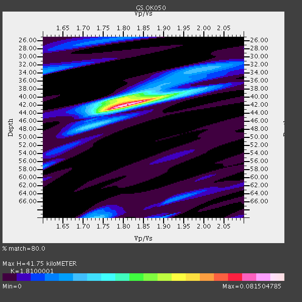
| Thickness Estimate: | 42 km |
| Thickness StdDev: | 0.3 km |
| Vp/Vs Estimate: | 1.81 |
| Vp/Vs StdDev: | 0.01 |
| Vs Estimate: | 3.582 km/s |
| Poisson's Ratio: | 0.28 |
| Peak Value: | 0.08 |
| Assumed Vp: | 6.483 km/s |
| Ps Weight: | 0.33333334 |
| PpPs Weight: | 0.33333334 |
| PsPs Weight: | 0.33333328 |
| Residual Complexity: | 0.446 |
| Nearby stations H: | +- |
| (2.0 deg) Vp/Vs: | +- |
1 with match > 90% ( 5.0 %) and 2 with match > 80% ( 10.0 %) out of 20.
Download stack as xyz text file.
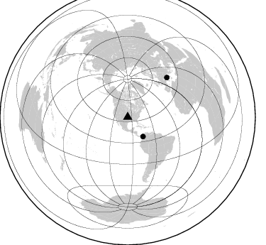
Azimuth Distribution of Events:
Prior Results for this Station
| Study | Thickness | Vp/Vs | Vp | Vs | Poissons Ratio | Extra |
| EARS | 42 km | 1.81 | 6.483 km/s | 3.582 km/s | 0.28 | |
| Crust2.0 | 46 km | 1.78 | 6.483 km/s | 3.648 km/s | 0.27 | D5,thick Platform 2 km seds. |
| Global Maxima | 42 km | 1.81 | 6.483 km/s | 3.582 km/s | 0.28 | amp=0.081504785 |
| Local Maxima 1 | 40 km | 1.79 | 6.483 km/s | 3.622 km/s | 0.27 | amp=0.036656957 |
| Local Maxima 2 | 70 km | 1.74 | 6.483 km/s | 3.731 km/s | 0.25 | amp=0.026545359 |
| Local Maxima 3 | 34 km | 1.60 | 6.483 km/s | 4.052 km/s | 0.18 | amp=0.019197369 |
| Local Maxima 4 | 33 km | 2.01 | 6.483 km/s | 3.229 km/s | 0.33 | amp=0.018283602 |
| Predicted Arrivals for vertical incidence (zero ray parameter) | |
| Ps | 5.22 SECOND |
| PpPs | 18.10 SECOND |
| PsPs/PpSs | 23.31 SECOND |
Events Processed for this Station
Download zip of receiver functions as SAC
Plot maxima for each earthquake.
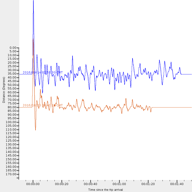
Events Used in the Stack
(2 events)| Radial Match | Distance | Baz | FERegion | Time | Lat/Lon | Depth | Magnitude |
| 93.51763 | 78.7 deg | 44.786 deg | Central Italy | 2016/10/30 06:40:19 GMT | (42.9, 13.1) | 10 km | 6.6 MWW, 6.6 MWR |
| 83.9751 | 34.7 deg | 141.549 deg | Northern Colombia | 2016/09/14 01:58:30 GMT | (7.3, -76.1) | 10 km | 5.9 MWP |
Losers
(18 events)| Radial Match | Distance | Baz | FERegion | Time | Lat/Lon | Depth | Magnitude | Reason |
| 79.544586 | 57.1 deg | 149.546 deg | Southern Peru | 2016/12/01 22:40:26 GMT | (-15.3, -70.8) | 10 km | 6.3 Mww | |
| 69.88555 | 52.2 deg | 146.859 deg | Peru-Brazil Border Region | 2016/12/18 13:30:11 GMT | (-10.0, -71.0) | 619 km | 6.4 Mww | |
| 65.49719 | 78.6 deg | 44.745 deg | Central Italy | 2016/10/26 19:18:08 GMT | (42.9, 13.0) | 10 km | 6.1 MWW, 6.0 MWB, 6.1 MWR | |
| 64.87478 | 61.6 deg | 315.648 deg | Near Islands, Aleutian Islands | 2016/12/03 09:23:34 GMT | (52.2, 174.2) | 27 km | 6.0 mb | |
| 62.583496 | 70.0 deg | 152.271 deg | La Rioja Province, Argentina | 2016/11/13 01:01:51 GMT | (-28.1, -67.3) | 121 km | 5.7 MB | |
| 61.59902 | 78.6 deg | 44.816 deg | Central Italy | 2016/10/26 17:10:37 GMT | (42.9, 13.0) | 10 km | 5.5 MWW | |
| 57.684498 | 72.2 deg | 183.429 deg | Southeast Of Easter Island | 2016/10/08 04:37:41 GMT | (-36.0, -101.0) | 10 km | 5.6 MWC, 5.6 MWC | |
| 51.895676 | 95.7 deg | 246.843 deg | South Of Fiji Islands | 2016/11/16 20:26:15 GMT | (-22.1, -177.6) | 305 km | 5.5 MB | |
| 51.675976 | 88.7 deg | 317.273 deg | Near East Coast Of Honshu, Japan | 2016/12/19 16:41:14 GMT | (37.5, 141.5) | 27 km | 5.5 mb | |
| 49.698395 | 65.4 deg | 321.44 deg | Komandorskiye Ostrova Region | 2016/11/24 22:31:01 GMT | (55.2, 164.6) | 38 km | 5.5 MB | |
| 48.244556 | 72.7 deg | 155.01 deg | San Juan Province, Argentina | 2016/11/20 20:57:43 GMT | (-31.6, -68.8) | 116 km | 6.4 MWP, 6.5 MWB | |
| 47.391136 | 75.1 deg | 158.181 deg | Chile-Argentina Border Region | 2016/11/04 16:20:43 GMT | (-35.1, -71.0) | 91 km | 6.4 MWP, 6.4 MWW | |
| 46.887604 | 81.2 deg | 47.329 deg | Tyrrhenian Sea | 2016/10/28 20:02:48 GMT | (39.3, 13.5) | 448 km | 5.8 MWW, 5.8 MWB | |
| 46.4036 | 81.9 deg | 163.622 deg | Southern Chile | 2016/12/25 14:22:28 GMT | (-43.3, -74.5) | 15 km | 7.7 Mi | |
| 44.03375 | 88.8 deg | 317.282 deg | Near East Coast Of Honshu, Japan | 2016/11/21 20:59:49 GMT | (37.4, 141.4) | 11 km | 6.9 MWB, 7.3 MI | |
| 43.646454 | 94.8 deg | 249.041 deg | Fiji Islands Region | 2016/09/24 21:28:42 GMT | (-19.8, -178.3) | 594 km | 6.8 MO | |
| 40.879658 | 80.6 deg | 318.394 deg | East Of Kuril Islands | 2016/10/23 20:25:26 GMT | (44.0, 148.2) | 30 km | 5.8 MB | |
| 20.901825 | 93.4 deg | 312.156 deg | Southeast Of Honshu, Japan | 2016/09/20 16:21:16 GMT | (30.5, 142.1) | 10 km | 6.1 MWW, 6.0 MWB |

