
Station GS PTRD - Partlow Road, Spotsylvania, VA 22551 USA
Network: GS - US Geological Survey Networks
Nearby stations (2 deg radius)
| Station | Name | (Lat, Lon) | Start / End | Elevation |
| PTRD | Partlow Road, Spotsylvania, VA 22551 USA | (38.12, -77.62) | 2011-08-26 / 2999-12-31 | 75 m |
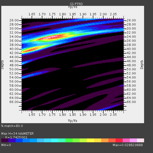
| Crust2 Type: | Q2,orogen/39km no ice, Appalachians, North Andes, 0.5 km seds. |
| Thickness Estimate: | 34 km |
| Thickness StdDev: | 2.8 km |
| Vp/Vs Estimate: | 1.74 |
| Vp/Vs StdDev: | 0.05 |
| Vs Estimate: | 3.684 km/s |
| Poisson's Ratio: | 0.25 |
| Peak Value: | 0.03 |
| Assumed Vp: | 6.419 km/s |
| Ps Weight: | 0.33333334 |
| PpPs Weight: | 0.33333334 |
| PsPs Weight: | 0.33333328 |
| Residual Complexity: | 0.470 |
| Nearby stations H: | +- |
| (2.0 deg) Vp/Vs: | +- |
4 with match > 90% ( 12.903226 %) and 5 with match > 80% ( 16.129032 %) out of 31.
Download stack as xyz text file.
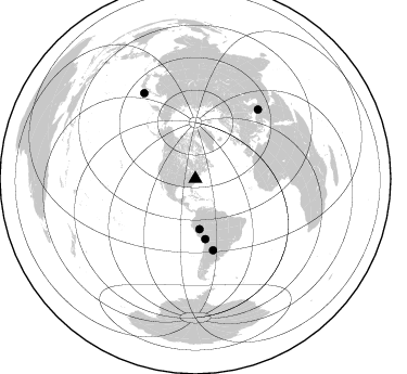
Azimuth Distribution of Events:
Prior Results for this Station
| Study | Thickness | Vp/Vs | Vp | Vs | Poissons Ratio | Extra |
| EARS | 34 km | 1.74 | 6.419 km/s | 3.684 km/s | 0.25 | |
| Crust2.0 | 39 km | 1.75 | 6.419 km/s | 3.659 km/s | 0.26 | Q2,orogen/39km no ice, Appalachians, North Andes, 0.5 km seds. |
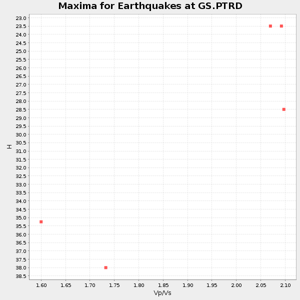
| Global Maxima | 34 km | 1.74 | 6.419 km/s | 3.684 km/s | 0.25 | amp=0.028829888 |
| Local Maxima 1 | 40 km | 1.64 | 6.419 km/s | 3.92 km/s | 0.20 | amp=0.017202333 |
| Local Maxima 2 | 34 km | 1.80 | 6.419 km/s | 3.576 km/s | 0.27 | amp=0.011503443 |
| Local Maxima 3 | 38 km | 1.69 | 6.419 km/s | 3.804 km/s | 0.23 | amp=0.0070068925 |
| Local Maxima 4 | 25 km | 1.93 | 6.419 km/s | 3.33 km/s | 0.32 | amp=0.0068035047 |
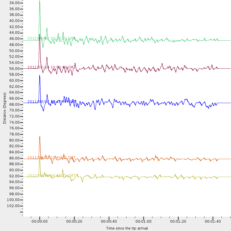
| Predicted Arrivals for vertical incidence (zero ray parameter) | |
| Ps | 3.93 SECOND |
| PpPs | 14.53 SECOND |
| PsPs/PpSs | 18.46 SECOND |
Events Processed for this Station
Download zip of receiver functions as SAC
Plot maxima for each earthquake.
Events Used in the Stack
(5 events)| Radial Match | Distance | Baz | FERegion | Time | Lat/Lon | Depth | Magnitude |
| 97.39146 | 86.3 deg | 42.138 deg | Turkey | 2011/10/23 10:41:22 GMT | (38.7, 43.5) | 16 km | 6.9 MB, 7.3 MS, 7.3 MW, 7.1 MW |
| 96.77017 | 92.3 deg | 329.118 deg | Off East Coast Of Honshu, Japan | 2012/03/14 09:08:35 GMT | (40.9, 144.9) | 12 km | 6.7 MB, 6.9 MS, 6.9 MW, 7.0 MW |
| 93.651665 | 46.4 deg | 175.402 deg | Peru-Brazil Border Region | 2012/08/02 09:38:30 GMT | (-8.4, -74.3) | 145 km | 5.9 MB, 6.1 MW, 6.1 MW |
| 90.009636 | 56.0 deg | 170.755 deg | Peru-Bolivia Border Region | 2012/05/14 10:00:40 GMT | (-17.7, -69.6) | 106 km | 6.4 MB, 6.2 MW, 6.2 MW |
| 81.84238 | 67.6 deg | 166.105 deg | Santiago Del Estero Prov., Arg. | 2011/09/02 13:47:09 GMT | (-28.4, -63.0) | 579 km | 6.4 MB, 6.7 MW, 6.7 MW |
Losers
(26 events)| Radial Match | Distance | Baz | FERegion | Time | Lat/Lon | Depth | Magnitude | Reason |
| 89.31127 | 36.7 deg | 304.32 deg | Vancouver Island, Canada Region | 2011/09/09 19:41:34 GMT | (49.5, -126.9) | 22 km | 6.3 MB, 6.4 MS, 6.4 MW, 6.5 MW | |
| 84.55406 | 86.2 deg | 42.115 deg | Turkey | 2011/10/23 10:56:49 GMT | (38.8, 43.4) | 5.0 km | 5.6 MB, 5.5 ML | |
| 78.26574 | 90.4 deg | 3.969 deg | Southwestern Siberia, Russia | 2012/02/26 06:17:19 GMT | (51.7, 96.0) | 12 km | 6.4 MB, 6.6 MS, 6.7 MW, 6.5 MW | |
| 71.55901 | 37.9 deg | 301.531 deg | Off Coast Of Washington | 2012/08/19 08:07:35 GMT | (47.8, -128.6) | 10 km | 5.6 MW, 5.3 MS, 5.2 MB, 5.5 MW | |
| 70.304825 | 67.2 deg | 166.083 deg | Santiago Del Estero Prov., Arg. | 2012/05/28 05:07:23 GMT | (-28.0, -63.1) | 587 km | 6.0 MB, 6.7 MW, 6.8 MW | |
| 70.06667 | 74.3 deg | 176.152 deg | Near Coast Of Central Chile | 2012/01/23 16:04:52 GMT | (-36.4, -73.0) | 20 km | 5.8 MB, 6.0 MS, 6.1 MW, 6.2 MW | |
| 65.86051 | 86.2 deg | 42.449 deg | Turkey | 2011/10/23 20:45:34 GMT | (38.6, 43.1) | 5.0 km | 6.0 MB, 5.6 MS, 6.0 MW, 5.9 MW | |
| 62.13205 | 63.5 deg | 316.503 deg | Fox Islands, Aleutian Islands | 2011/09/19 08:14:14 GMT | (52.0, -172.0) | 31 km | 5.5 MB, 5.1 MS, 5.7 MW, 5.6 MW | |
| 56.693314 | 67.4 deg | 166.317 deg | Santiago Del Estero Prov., Arg. | 2012/03/05 07:46:10 GMT | (-28.2, -63.3) | 554 km | 6.0 MB, 6.1 MW, 6.1 MW | |
| 55.248894 | 30.9 deg | 262.955 deg | Baja California, Mexico | 2012/04/12 07:15:48 GMT | (28.7, -113.1) | 13 km | 6.2 MB, 6.9 MS, 7.0 MW, 6.9 MW | |
| 54.95722 | 93.5 deg | 329.882 deg | Off East Coast Of Honshu, Japan | 2011/09/16 20:11:16 GMT | (40.2, 143.2) | 35 km | 5.5 MB, 5.8 MW | |
| 54.435738 | 80.8 deg | 327.855 deg | Kuril Islands | 2012/07/20 06:10:25 GMT | (49.4, 155.9) | 19 km | 5.7 MB, 5.7 MS, 6.0 MW, 6.1 MW | |
| 53.746838 | 90.7 deg | 332.243 deg | Hokkaido, Japan Region | 2011/10/21 08:02:37 GMT | (43.9, 142.5) | 187 km | 5.9 MB, 6.1 MW, 6.1 MW | |
| 51.488293 | 58.0 deg | 170.512 deg | Northern Chile | 2012/04/03 07:25:08 GMT | (-19.6, -69.1) | 117 km | 5.5 ML, 5.2 MB | |
| 49.420647 | 60.7 deg | 315.673 deg | Fox Islands, Aleutian Islands | 2012/08/10 18:37:43 GMT | (52.6, -167.4) | 13 km | 5.9 MB, 6.2 MS, 6.2 MW, 6.2 MW | |
| 49.20279 | 85.9 deg | 38.377 deg | Eastern Caucasus | 2012/05/07 04:40:27 GMT | (41.5, 46.8) | 11 km | 5.7 MB, 5.7 MS, 5.6 MW, 5.6 MW | |
| 44.20062 | 66.0 deg | 173.504 deg | Near Coast Of Northern Chile | 2011/12/07 22:23:09 GMT | (-27.9, -70.9) | 20 km | 5.8 MB, 5.8 MS, 6.1 MW, 6.0 MW | |
| 41.04711 | 98.2 deg | 24.814 deg | Afghanistan-Tajikistan Bord Reg. | 2012/05/12 23:28:43 GMT | (38.6, 70.4) | 10 km | 6.0 MB, 5.7 MS, 5.7 MW, 5.9 MW | |
| 40.48154 | 63.3 deg | 316.572 deg | Fox Islands, Aleutian Islands | 2011/10/25 03:24:49 GMT | (52.2, -171.8) | 38 km | 5.9 MB, 5.3 MS, 5.7 MW, 5.7 MW | |
| 40.255314 | 88.8 deg | 336.034 deg | Primor'ye, Russia | 2012/07/29 09:20:54 GMT | (47.4, 139.1) | 502 km | 5.6 MB, 5.6 MW, 5.7 MW | |
| 38.39546 | 70.4 deg | 107.444 deg | North Of Ascension Island | 2012/05/09 14:49:51 GMT | (-1.0, -13.6) | 12 km | 5.5 MW, 5.0 MS, 5.4 MB, 5.6 MW | |
| 36.33283 | 56.5 deg | 316.449 deg | Alaska Peninsula | 2012/08/08 14:05:17 GMT | (54.9, -161.2) | 43 km | 5.6 MB, 5.2 MW, 5.1 MW | |
| 33.83326 | 61.3 deg | 165.104 deg | Salta Province, Argentina | 2012/06/02 07:52:53 GMT | (-22.1, -63.6) | 527 km | 5.8 MB, 5.9 MW, 6.0 MW | |
| 21.788475 | 70.7 deg | 174.796 deg | Near Coast Of Central Chile | 2011/09/14 07:03:51 GMT | (-32.7, -71.8) | 37 km | 5.5 MS, 5.4 MB, 5.9 MW, 5.7 MW | |
| 15.873999 | 77.2 deg | 200.69 deg | Southeast Of Easter Island | 2012/05/02 17:06:05 GMT | (-35.9, -102.7) | 10 km | 5.5 MW, 4.9 MS, 4.7 MB | |
| 15.653438 | 63.2 deg | 166.283 deg | Salta Province, Argentina | 2011/10/06 11:12:30 GMT | (-24.2, -64.2) | 15 km | 6.5 MB, 5.7 MS, 6.1 MW, 5.9 MW |
