
Station GS TST4 - ASL test vault
Network: GS - US Geological Survey Networks
Nearby stations (2 deg radius)
| Station | Name | (Lat, Lon) | Start / End | Elevation |
| TST4 | ASL test vault | (34.94, -106.46) | 2019-08-21 / 2599-12-31 | 1854 m |
| Crust2 Type: | X2,Rift, Rio Grande, Baikal, 0.5km sediments |
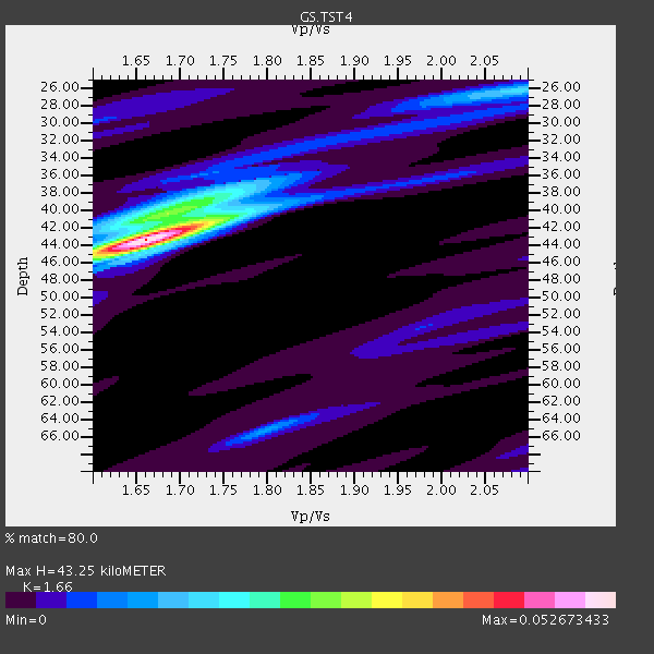
| Thickness Estimate: | 43 km |
| Thickness StdDev: | 2.6 km |
| Vp/Vs Estimate: | 1.66 |
| Vp/Vs StdDev: | 0.06 |
| Vs Estimate: | 3.917 km/s |
| Poisson's Ratio: | 0.22 |
| Peak Value: | 0.05 |
| Assumed Vp: | 6.502 km/s |
| Ps Weight: | 0.33333334 |
| PpPs Weight: | 0.33333334 |
| PsPs Weight: | 0.33333328 |
| Residual Complexity: | 0.476 |
| Nearby stations H: | 42 km +- 2.4 km |
| (2.0 deg) Vp/Vs: | 1.66 +- 0.03 |
2 with match > 90% ( 33.333332 %) and 3 with match > 80% ( 50.0 %) out of 6.
Download stack as xyz text file.
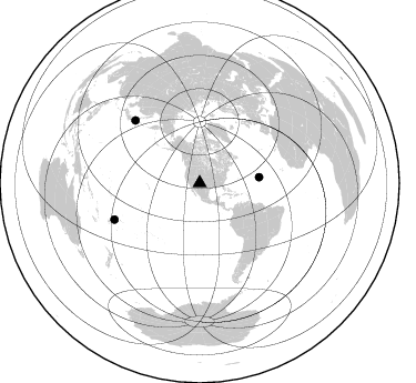
Azimuth Distribution of Events:
Prior Results for this Station
| Study | Thickness | Vp/Vs | Vp | Vs | Poissons Ratio | Extra |
| EARS | 43 km | 1.66 | 6.502 km/s | 3.917 km/s | 0.22 | |
| Crust2.0 | 33 km | 1.77 | 6.502 km/s | 3.68 km/s | 0.26 | X2,Rift, Rio Grande, Baikal, 0.5km sediments |
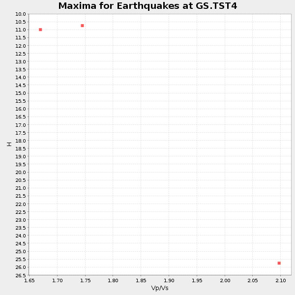
| Global Maxima | 43 km | 1.66 | 6.502 km/s | 3.917 km/s | 0.22 | amp=0.052673433 |
| Local Maxima 1 | 40 km | 1.69 | 6.502 km/s | 3.858 km/s | 0.23 | amp=0.021469243 |
| Local Maxima 2 | 41 km | 1.74 | 6.502 km/s | 3.747 km/s | 0.25 | amp=0.012316326 |
| Local Maxima 3 | 26 km | 2.08 | 6.502 km/s | 3.122 km/s | 0.35 | amp=0.011650593 |
| Local Maxima 4 | 65 km | 1.80 | 6.502 km/s | 3.612 km/s | 0.28 | amp=0.011393828 |
| Predicted Arrivals for vertical incidence (zero ray parameter) | |
| Ps | 4.39 SECOND |
| PpPs | 17.70 SECOND |
| PsPs/PpSs | 22.09 SECOND |
Events Processed for this Station
Download zip of receiver functions as SAC
Plot maxima for each earthquake.
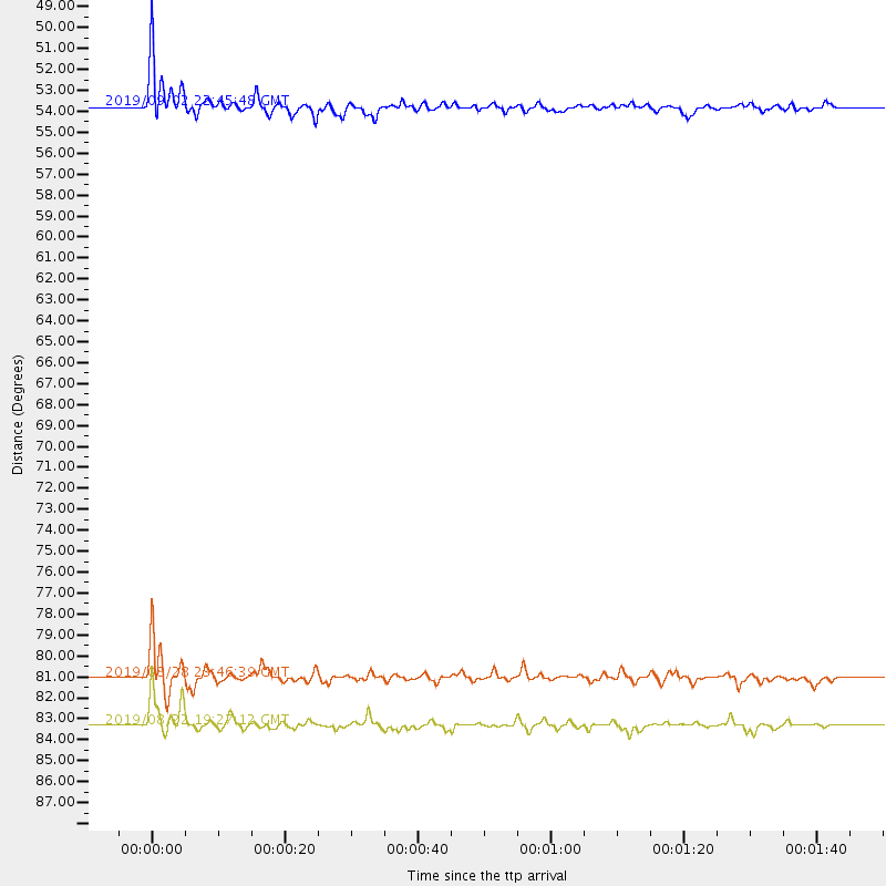
Events Used in the Stack
(3 events)| Radial Match | Distance | Baz | FERegion | Time | Lat/Lon | Depth | Magnitude |
| 95.2205 | 81.1 deg | 314.225 deg | Hokkaido, Japan Region | 2019/08/28 23:46:39 GMT | (41.1, 143.0) | 17 km | 6.1 Mww |
| 92.430885 | 53.8 deg | 84.475 deg | Northern Mid-Atlantic Ridge | 2019/09/02 22:45:48 GMT | (23.8, -45.2) | 10 km | 5.9 Mww |
| 88.74886 | 83.3 deg | 246.912 deg | Fiji Islands Region | 2019/08/22 19:27:12 GMT | (-14.8, -177.3) | 10 km | 5.8 Mww |
Losers
(3 events)| Radial Match | Distance | Baz | FERegion | Time | Lat/Lon | Depth | Magnitude | Reason |
| 73.59096 | 94.3 deg | 257.737 deg | Santa Cruz Islands | 2019/08/22 22:54:26 GMT | (-12.6, 167.0) | 213 km | 5.6 Mww | |
| 57.37375 | 85.5 deg | 241.725 deg | Tonga Islands | 2019/08/24 21:21:27 GMT | (-20.2, -175.6) | 215 km | 5.5 Mww | |
| 56.410522 | 84.8 deg | 185.497 deg | Southern East Pacific Rise | 2019/09/01 02:34:50 GMT | (-49.9, -114.9) | 10 km | 5.5 Mww |

