
Station GS TST5 - ASL Experiment
Network: GS - US Geological Survey Networks
Nearby stations (2 deg radius)
| Station | Name | (Lat, Lon) | Start / End | Elevation |
| TST5 | ASL Experiment | (34.94, -106.46) | 2016-07-14 / 2016-08-11 | 1850 m |
| Crust2 Type: | X2,Rift, Rio Grande, Baikal, 0.5km sediments |
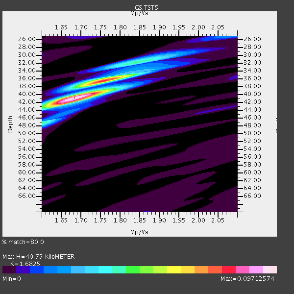
| Thickness Estimate: | 41 km |
| Thickness StdDev: | 2.3 km |
| Vp/Vs Estimate: | 1.68 |
| Vp/Vs StdDev: | 0.04 |
| Vs Estimate: | 3.864 km/s |
| Poisson's Ratio: | 0.23 |
| Peak Value: | 0.10 |
| Assumed Vp: | 6.502 km/s |
| Ps Weight: | 0.33333334 |
| PpPs Weight: | 0.33333334 |
| PsPs Weight: | 0.33333328 |
| Residual Complexity: | 0.514 |
| Nearby stations H: | 42 km +- 2.4 km |
| (2.0 deg) Vp/Vs: | 1.66 +- 0.04 |
3 with match > 90% ( 33.333332 %) and 3 with match > 80% ( 33.333332 %) out of 9.
Download stack as xyz text file.
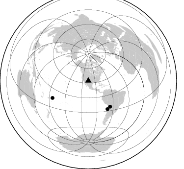
Azimuth Distribution of Events:
Prior Results for this Station
| Study | Thickness | Vp/Vs | Vp | Vs | Poissons Ratio | Extra |
| EARS | 41 km | 1.68 | 6.502 km/s | 3.864 km/s | 0.23 | |
| Crust2.0 | 33 km | 1.77 | 6.502 km/s | 3.68 km/s | 0.26 | X2,Rift, Rio Grande, Baikal, 0.5km sediments |
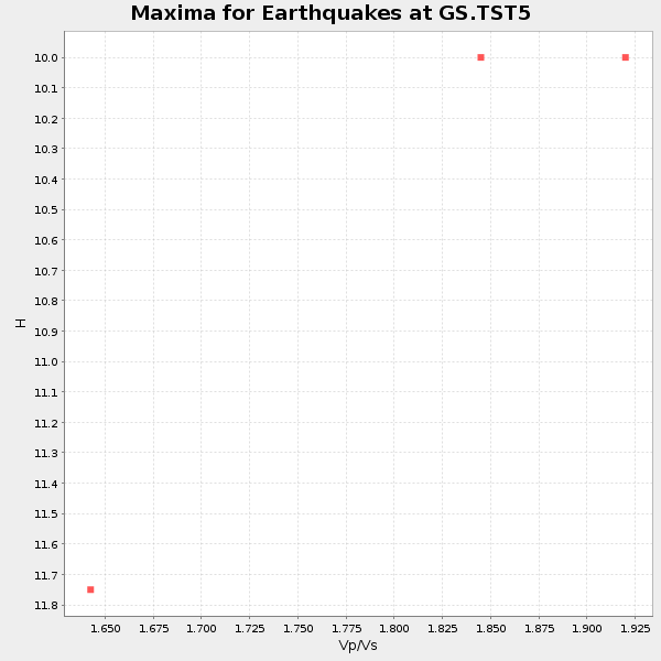
| Global Maxima | 41 km | 1.68 | 6.502 km/s | 3.864 km/s | 0.23 | amp=0.09712574 |
| Local Maxima 1 | 36 km | 1.76 | 6.502 km/s | 3.689 km/s | 0.26 | amp=0.06617402 |
| Local Maxima 2 | 32 km | 1.84 | 6.502 km/s | 3.538 km/s | 0.29 | amp=0.03069958 |
| Local Maxima 3 | 47 km | 1.60 | 6.502 km/s | 4.063 km/s | 0.18 | amp=0.023493906 |
| Local Maxima 4 | 42 km | 1.65 | 6.502 km/s | 3.94 km/s | 0.21 | amp=0.017162582 |
| Predicted Arrivals for vertical incidence (zero ray parameter) | |
| Ps | 4.28 SECOND |
| PpPs | 16.81 SECOND |
| PsPs/PpSs | 21.09 SECOND |
Events Processed for this Station
Download zip of receiver functions as SAC
Plot maxima for each earthquake.
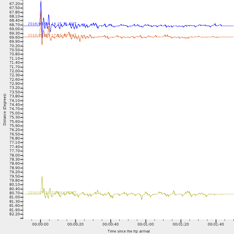
Events Used in the Stack
(3 events)| Radial Match | Distance | Baz | FERegion | Time | Lat/Lon | Depth | Magnitude |
| 95.812096 | 69.5 deg | 145.839 deg | Near Coast Of Northern Chile | 2016/07/25 17:26:49 GMT | (-26.1, -70.6) | 68 km | 6.2 MB |
| 90.54492 | 68.7 deg | 139.871 deg | Jujuy Province, Argentina | 2016/08/04 14:15:11 GMT | (-22.4, -66.0) | 258 km | 6.0 MO |
| 90.009964 | 80.8 deg | 244.412 deg | Tonga Islands | 2016/07/23 20:09:19 GMT | (-15.1, -173.6) | 10 km | 5.7 MB |
Losers
(6 events)| Radial Match | Distance | Baz | FERegion | Time | Lat/Lon | Depth | Magnitude | Reason |
| 98.80419 | 93.5 deg | 295.303 deg | Mariana Islands | 2016/07/29 21:18:25 GMT | (18.5, 145.5) | 212 km | 7.7 MWW, 7.7 MWB, 7.7 MI | |
| 77.18471 | 74.8 deg | 317.878 deg | Northwest Of Kuril Islands | 2016/07/23 01:00:21 GMT | (47.7, 147.0) | 407 km | 5.7 MB | |
| 71.67397 | 92.0 deg | 302.338 deg | Volcano Islands, Japan Region | 2016/08/04 16:24:33 GMT | (24.9, 142.0) | 510 km | 6.3 MWW, 6.2 MWC, 6.3 MWB, 6.3 MWC | |
| 66.934074 | 79.2 deg | 96.457 deg | Central Mid-Atlantic Ridge | 2016/07/24 14:10:51 GMT | (0.9, -29.0) | 10 km | 5.7 mwb | |
| 61.141922 | 40.4 deg | 321.63 deg | Alaska Peninsula | 2016/07/23 09:59:00 GMT | (58.6, -156.6) | 204 km | 5.7 MB, 5.1 MI, 5.4 ML | |
| 50.53726 | 96.3 deg | 251.456 deg | Vanuatu Islands | 2016/07/20 15:13:16 GMT | (-18.9, 169.0) | 164 km | 6.0 MO |

