
Station GS TSVA - Taos Kachina Peak Avalanche Study
Network: GS - US Geological Survey Networks
Nearby stations (2 deg radius)
| Station | Name | (Lat, Lon) | Start / End | Elevation |
| TSVA | Taos Kachina Peak Avalanche Study | (36.57, -105.45) | 2021-01-03 / 2499-01-01 | 3000 m |
| Crust2 Type: | PC,orogen/45km, Orogen, 1 km seds. |
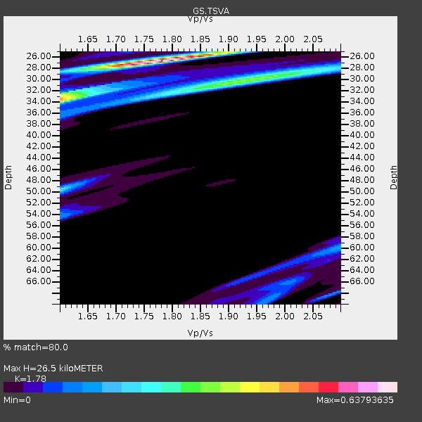
| Thickness Estimate: | 26 km |
| Thickness StdDev: | 11 km |
| Vp/Vs Estimate: | 1.78 |
| Vp/Vs StdDev: | 0.10 |
| Vs Estimate: | 3.548 km/s |
| Poisson's Ratio: | 0.27 |
| Peak Value: | 0.64 |
| Assumed Vp: | 6.316 km/s |
| Ps Weight: | 0.33333334 |
| PpPs Weight: | 0.33333334 |
| PsPs Weight: | 0.33333328 |
| Residual Complexity: | 0.657 |
| Nearby stations H: | +- |
| (2.0 deg) Vp/Vs: | +- |
0 with match > 90% ( 0.0 %) and 2 with match > 80% ( 3.6363637 %) out of 55.
Download stack as xyz text file.
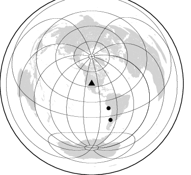
Azimuth Distribution of Events:
Prior Results for this Station
| Study | Thickness | Vp/Vs | Vp | Vs | Poissons Ratio | Extra |
| EARS | 26 km | 1.78 | 6.316 km/s | 3.548 km/s | 0.27 | |
| Crust2.0 | 45 km | 1.76 | 6.316 km/s | 3.587 km/s | 0.26 | PC,orogen/45km, Orogen, 1 km seds. |
| Global Maxima | 26 km | 1.78 | 6.316 km/s | 3.548 km/s | 0.27 | amp=0.63793635 |
| Local Maxima 1 | 34 km | 1.60 | 6.316 km/s | 3.947 km/s | 0.18 | amp=0.3576693 |
| Local Maxima 2 | 31 km | 1.88 | 6.316 km/s | 3.364 km/s | 0.30 | amp=0.2591705 |
| Local Maxima 3 | 50 km | 1.60 | 6.316 km/s | 3.947 km/s | 0.18 | amp=0.21120921 |
| Local Maxima 4 | 32 km | 1.60 | 6.316 km/s | 3.947 km/s | 0.18 | amp=0.1557983 |
| Predicted Arrivals for vertical incidence (zero ray parameter) | |
| Ps | 3.27 SECOND |
| PpPs | 11.66 SECOND |
| PsPs/PpSs | 14.94 SECOND |
Events Processed for this Station
Download zip of receiver functions as SAC
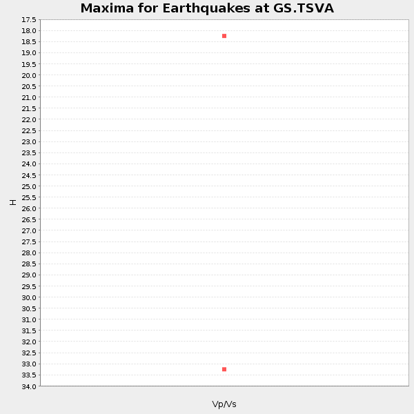
Plot maxima for each earthquake.
Events Used in the Stack
(2 events)| Radial Match | Distance | Baz | FERegion | Time | Lat/Lon | Depth | Magnitude |
| 88.819534 | 58.6 deg | 145.599 deg | Near Coast Of Peru | 2021/01/20 22:59:12 UTC | (-15.0, -75.5) | 10 km | 5.5 Mww |
| 82.71831 | 80.2 deg | 152.589 deg | Southern Argentina | 2021/04/29 02:17:16 UTC | (-37.3, -70.8) | 137 km | 5.7 Mww |
Losers
(53 events)| Radial Match | Distance | Baz | FERegion | Time | Lat/Lon | Depth | Magnitude | Reason |
| 96.63446 | 37.4 deg | 329.219 deg | Central Alaska | 2021/04/08 17:10:15 UTC | (63.2, -148.7) | 0.7 km | 5.9 ml | |
| 95.59584 | 92.7 deg | 236.752 deg | Kermadec Islands Region | 2021/03/13 21:21:57 UTC | (-28.1, -176.5) | 10 km | 5.9 Mww | |
| 92.83942 | 97.5 deg | 247.563 deg | Southeast Of Loyalty Islands | 2021/02/04 12:14:26 UTC | (-22.6, 171.9) | 10 km | 5.7 mww | |
| 92.56665 | 89.9 deg | 37.654 deg | Greece | 2021/03/12 12:57:51 UTC | (39.9, 22.0) | 10 km | 5.6 Mww | |
| 87.628265 | 93.4 deg | 236.214 deg | Kermadec Islands Region | 2021/03/05 01:59:48 UTC | (-29.0, -176.7) | 10 km | 5.1 mb | |
| 87.259476 | 93.0 deg | 236.631 deg | Kermadec Islands Region | 2021/03/04 20:25:06 UTC | (-28.4, -176.6) | 10 km | 6.1 mb | |
| 83.418434 | 93.6 deg | 235.988 deg | Kermadec Islands Region | 2021/04/26 21:07:28 UTC | (-29.3, -176.7) | 10 km | 5.8 mww | |
| 82.57324 | 97.9 deg | 247.505 deg | Southeast Of Loyalty Islands | 2021/02/10 12:24:21 UTC | (-22.9, 171.7) | 10 km | 6.0 mww | |
| 82.49845 | 98.3 deg | 247.93 deg | Southeast Of Loyalty Islands | 2021/02/10 20:45:14 UTC | (-22.8, 171.1) | 10 km | 5.3 mb | |
| 80.45141 | 97.7 deg | 247.654 deg | Southeast Of Loyalty Islands | 2021/03/06 18:47:12 UTC | (-22.6, 171.8) | 29 km | 5.1 Mww | |
| 80.08167 | 94.2 deg | 235.973 deg | Kermadec Islands, New Zealand | 2021/03/04 23:37:09 UTC | (-29.7, -177.2) | 10 km | 5.6 mb | |
| 79.98768 | 98.2 deg | 247.284 deg | Southeast Of Loyalty Islands | 2021/02/12 10:06:01 UTC | (-23.2, 171.6) | 10 km | 5.7 mww | |
| 79.795815 | 92.4 deg | 241.389 deg | South Of Fiji Islands | 2021/01/23 11:47:33 UTC | (-24.3, -179.5) | 425 km | 5.5 mww | |
| 79.38436 | 98.0 deg | 262.475 deg | Solomon Islands | 2021/01/09 23:01:12 UTC | (-10.8, 162.5) | 11 km | 5.3 Mww | |
| 79.07037 | 89.7 deg | 344.072 deg | Russia-Mongolia Border Region | 2021/01/11 21:32:58 UTC | (51.2, 100.4) | 10 km | 6.7 mww | |
| 78.43679 | 70.5 deg | 142.591 deg | Salta Province, Argentina | 2021/01/10 03:54:12 UTC | (-24.0, -66.7) | 203 km | 6.1 mww | |
| 77.98003 | 93.8 deg | 235.739 deg | Kermadec Islands Region | 2021/03/05 03:53:04 UTC | (-29.6, -176.7) | 10 km | 5.6 mww | |
| 75.62368 | 90.0 deg | 37.69 deg | Greece | 2021/03/03 18:24:08 UTC | (39.7, 22.1) | 10 km | 5.1 Mww | |
| 75.55602 | 94.3 deg | 235.955 deg | Kermadec Islands, New Zealand | 2021/03/04 19:28:31 UTC | (-29.7, -177.3) | 19 km | 8.1 mww | |
| 74.63957 | 94.3 deg | 235.403 deg | Kermadec Islands Region | 2021/03/06 17:13:13 UTC | (-30.2, -176.9) | 10 km | 5.6 Mww | |
| 74.62436 | 72.5 deg | 319.359 deg | Sea Of Okhotsk | 2021/01/20 16:00:40 UTC | (49.7, 147.7) | 575 km | 5.5 Mww | |
| 73.176575 | 92.9 deg | 298.544 deg | Mariana Islands | 2021/03/06 18:51:13 UTC | (20.9, 144.3) | 10 km | 5.7 Mww | |
| 72.176025 | 87.0 deg | 310.378 deg | Southeast Of Honshu, Japan | 2021/03/28 00:26:56 UTC | (33.6, 140.3) | 48 km | 5.7 mww | |
| 71.624 | 93.1 deg | 236.498 deg | Kermadec Islands Region | 2021/03/04 22:05:56 UTC | (-28.6, -176.7) | 10 km | 5.5 mb | |
| 69.84711 | 98.2 deg | 247.758 deg | Southeast Of Loyalty Islands | 2021/02/11 08:22:10 UTC | (-22.9, 171.2) | 10 km | 5.9 mww | |
| 69.67389 | 94.3 deg | 235.698 deg | Kermadec Islands, New Zealand | 2021/03/04 22:33:44 UTC | (-29.9, -177.1) | 10 km | 5.8 mb | |
| 69.59164 | 84.4 deg | 246.967 deg | Fiji Islands Region | 2021/02/18 15:30:50 UTC | (-14.9, -176.7) | 10 km | 6.1 mww | |
| 69.40449 | 94.1 deg | 235.575 deg | Kermadec Islands Region | 2021/03/06 03:59:46 UTC | (-29.9, -176.9) | 10 km | 5.5 mww | |
| 65.41541 | 97.8 deg | 247.136 deg | Southeast Of Loyalty Islands | 2021/02/11 11:19:26 UTC | (-23.1, 172.0) | 10 km | 5.6 mb | |
| 64.76558 | 76.2 deg | 148.486 deg | San Juan Province, Argentina | 2021/01/19 02:46:22 UTC | (-31.8, -68.8) | 20 km | 6.4 mww | |
| 63.85858 | 34.9 deg | 138.551 deg | Panama-Costa Rica Border Region | 2021/01/29 12:41:39 UTC | (8.2, -83.0) | 10 km | 5.6 Mww | |
| 62.685596 | 94.1 deg | 236.526 deg | Kermadec Islands, New Zealand | 2021/04/26 13:42:22 UTC | (-29.2, -177.6) | 60 km | 5.5 mb | |
| 61.54538 | 98.3 deg | 247.863 deg | Southeast Of Loyalty Islands | 2021/02/10 16:35:23 UTC | (-22.8, 171.1) | 10 km | 6.1 mww | |
| 60.782703 | 96.3 deg | 256.792 deg | Vanuatu Islands | 2021/03/04 16:53:11 UTC | (-14.4, 167.3) | 172 km | 6.1 Mww | |
| 60.485363 | 80.5 deg | 318.018 deg | Eastern Sea Of Japan | 2021/01/12 02:39:42 UTC | (43.7, 140.0) | 211 km | 5.9 mww | |
| 58.7748 | 83.0 deg | 312.994 deg | Near East Coast Of Honshu, Japan | 2021/04/18 00:29:25 UTC | (38.3, 141.8) | 31 km | 5.6 mb | |
| 58.62168 | 93.0 deg | 236.552 deg | Kermadec Islands Region | 2021/03/04 23:12:57 UTC | (-28.5, -176.6) | 10 km | 6.2 mb | |
| 56.86763 | 92.9 deg | 236.632 deg | Kermadec Islands Region | 2021/03/04 22:41:05 UTC | (-28.4, -176.6) | 10 km | 5.8 mb | |
| 54.854618 | 76.7 deg | 152.202 deg | Off Coast Of Central Chile | 2021/04/22 00:17:14 UTC | (-34.0, -72.3) | 7.5 km | 5.5 Mww | |
| 54.74183 | 93.4 deg | 236.648 deg | Kermadec Islands Region | 2021/03/06 07:16:19 UTC | (-28.6, -177.0) | 10 km | 5.6 mb | |
| 53.73461 | 97.9 deg | 253.971 deg | Vanuatu Islands | 2021/02/16 01:22:19 UTC | (-17.6, 167.7) | 10 km | 5.5 mb | |
| 53.22727 | 79.9 deg | 239.012 deg | Tonga Islands Region | 2021/02/16 00:49:28 UTC | (-17.8, -167.8) | 14 km | 6.7 Mi | |
| 53.152447 | 92.6 deg | 298.612 deg | Mariana Islands Region | 2021/03/06 18:18:34 UTC | (21.1, 144.5) | 14 km | 5.5 mww | |
| 53.01562 | 93.1 deg | 236.106 deg | Kermadec Islands Region | 2021/03/04 22:55:37 UTC | (-28.9, -176.4) | 10 km | 5.6 mb | |
| 52.43976 | 94.2 deg | 237.38 deg | Kermadec Islands Region | 2021/03/06 07:20:29 UTC | (-28.6, -178.2) | 10 km | 5.5 mb | |
| 50.2702 | 98.1 deg | 253.964 deg | Vanuatu Islands | 2021/02/16 00:49:26 UTC | (-17.8, 167.5) | 10 km | 6.2 Mww | |
| 50.105362 | 82.9 deg | 313.022 deg | Near East Coast Of Honshu, Japan | 2021/04/18 00:29:12 UTC | (38.4, 141.9) | 52 km | 5.6 mww | |
| 49.68899 | 82.7 deg | 49.125 deg | Northern Algeria | 2021/03/18 00:04:06 UTC | (36.9, 5.2) | 8.0 km | 6.0 mww | |
| 49.10232 | 77.0 deg | 150.295 deg | Chile-Argentina Border Region | 2021/01/24 00:07:45 UTC | (-33.4, -70.2) | 111 km | 5.8 Mww | |
| 45.061897 | 93.5 deg | 236.379 deg | Kermadec Islands Region | 2021/03/04 19:43:45 UTC | (-28.9, -176.9) | 10 km | 5.6 mb | |
| 44.29085 | 94.5 deg | 235.788 deg | Kermadec Islands, New Zealand | 2021/03/04 17:59:11 UTC | (-30.0, -177.4) | 10 km | 5.6 mb | |
| 32.61927 | 86.6 deg | 243.574 deg | Fiji Islands Region | 2021/04/24 00:23:36 UTC | (-18.9, -176.2) | 289 km | 6.4 Mww | |
| 28.421566 | 89.5 deg | 344.099 deg | Russia-Mongolia Border Region | 2021/01/11 21:44:04 UTC | (51.4, 100.5) | 10 km | 5.7 mb |

