
Station HV TAU - Ta'?? telecommunications tower
Network: HV - Hawaiian Volcano Observatory Network
Nearby stations (2 deg radius)
| Station | Name | (Lat, Lon) | Start / End | Elevation |
| TAU | Ta'?? telecommunications tower | (-14.22, -169.51) | 2022-08-20 / 2499-01-01 | 100 m |
| Crust2 Type: | A0,normal oceanic, 0.07 km seds. |
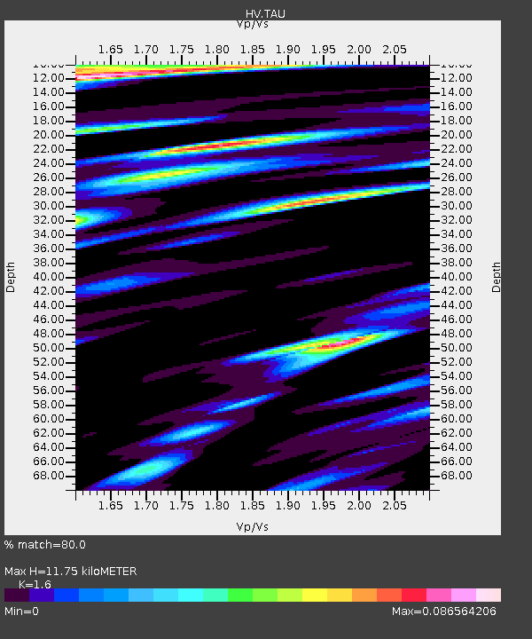
| Thickness Estimate: | 12 km |
| Thickness StdDev: | 17 km |
| Vp/Vs Estimate: | 1.60 |
| Vp/Vs StdDev: | 0.16 |
| Vs Estimate: | 2.65 km/s |
| Poisson's Ratio: | 0.18 |
| Peak Value: | 0.09 |
| Assumed Vp: | 4.24 km/s |
| Ps Weight: | 0.33333334 |
| PpPs Weight: | 0.33333334 |
| PsPs Weight: | 0.33333328 |
| Residual Complexity: | 0.857 |
| Nearby stations H: | +- |
| (2.0 deg) Vp/Vs: | +- |
1 with match > 90% ( 4.7619047 %) and 3 with match > 80% ( 14.285714 %) out of 21.
Download stack as xyz text file.
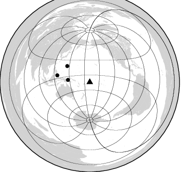
Azimuth Distribution of Events:
Prior Results for this Station
| Study | Thickness | Vp/Vs | Vp | Vs | Poissons Ratio | Extra |
| EARS | 12 km | 1.60 | 4.24 km/s | 2.65 km/s | 0.18 | |
| Crust2.0 | 12 km | 2.19 | 4.24 km/s | 1.94 km/s | 0.37 | A0,normal oceanic, 0.07 km seds. |
| Global Maxima | 12 km | 1.60 | 4.24 km/s | 2.65 km/s | 0.18 | amp=0.086564206 |
| Local Maxima 1 | 49 km | 1.97 | 4.24 km/s | 2.152 km/s | 0.33 | amp=0.07920259 |
| Local Maxima 2 | 21 km | 1.80 | 4.24 km/s | 2.352 km/s | 0.28 | amp=0.07370188 |
| Local Maxima 3 | 29 km | 1.93 | 4.24 km/s | 2.2 km/s | 0.32 | amp=0.068159305 |
| Local Maxima 4 | 26 km | 1.72 | 4.24 km/s | 2.461 km/s | 0.25 | amp=0.05590858 |
| Predicted Arrivals for vertical incidence (zero ray parameter) | |
| Ps | 1.66 SECOND |
| PpPs | 7.21 SECOND |
| PsPs/PpSs | 8.87 SECOND |
Events Processed for this Station
Download zip of receiver functions as SAC
Plot maxima for each earthquake.
Events Used in the Stack
(3 events)| Radial Match | Distance | Baz | FERegion | Time | Lat/Lon | Depth | Magnitude |
| 92.526596 | 44.0 deg | 275.796 deg | Eastern New Guinea Reg., P.N.G. | 2022/09/10 23:46:55 UTC | (-6.2, 146.5) | 61 km | 7.6 mww |
| 82.69781 | 55.4 deg | 305.539 deg | Mariana Islands | 2024/04/05 11:03:16 UTC | (19.1, 145.4) | 222 km | 6.8 mww |
| 81.20265 | 66.4 deg | 281.817 deg | Talaud Islands, Indonesia | 2024/01/08 20:48:46 UTC | (4.9, 126.3) | 91 km | 7.0 Mi |
Losers
(18 events)| Radial Match | Distance | Baz | FERegion | Time | Lat/Lon | Depth | Magnitude | Reason |
| 89.00243 | 71.8 deg | 317.535 deg | Near West Coast Of Honshu, Japan | 2024/01/01 07:56:48 UTC | (37.3, 136.9) | 10 km | 5.6 Mww | |
| 71.79779 | 55.9 deg | 145.406 deg | Southern East Pacific Rise | 2023/12/27 21:33:18 UTC | (-53.1, -118.3) | 10 km | 5.7 mww | |
| 69.76654 | 37.6 deg | 280.779 deg | New Ireland Region, P.N.G. | 2022/10/13 22:20:20 UTC | (-4.8, 153.6) | 71 km | 6.4 mww | |
| 67.81884 | 43.8 deg | 277.068 deg | Eastern New Guinea Reg., P.N.G. | 2023/03/14 00:49:08 UTC | (-5.4, 146.9) | 213 km | 6.3 mww | |
| 66.31239 | 90.9 deg | 118.455 deg | Near Coast Of Northern Chile | 2023/04/04 19:08:46 UTC | (-27.4, -71.0) | 51 km | 5.9 mww | |
| 65.65925 | 39.6 deg | 278.119 deg | New Britain Region, P.N.G. | 2024/04/14 20:56:28 UTC | (-5.8, 151.1) | 49 km | 6.5 mww | |
| 65.47731 | 65.0 deg | 279.835 deg | Northern Molucca Sea | 2024/04/09 09:48:01 UTC | (2.7, 127.1) | 35 km | 6.6 mww | |
| 63.6389 | 30.7 deg | 274.772 deg | Solomon Islands | 2022/11/22 02:07:53 UTC | (-9.8, 159.4) | 10 km | 5.6 mb | |
| 63.39435 | 90.1 deg | 120.516 deg | Near Coast Of Central Chile | 2023/02/05 01:02:45 UTC | (-29.6, -71.2) | 68 km | 5.5 mww | |
| 63.389156 | 88.0 deg | 84.543 deg | South Of Panama | 2022/12/12 18:27:34 UTC | (4.8, -82.8) | 10 km | 5.5 mww | |
| 60.61801 | 70.9 deg | 336.738 deg | Kuril Islands | 2023/04/07 02:22:41 UTC | (49.9, 155.3) | 86 km | 5.8 mww | |
| 60.10066 | 69.6 deg | 290.034 deg | Philippine Islands Region | 2022/12/09 06:32:59 UTC | (13.2, 125.8) | 9.0 km | 5.8 mww | |
| 59.528072 | 77.2 deg | 298.353 deg | Taiwan | 2022/09/19 02:07:43 UTC | (23.4, 121.4) | 13 km | 5.5 Mww | |
| 57.38163 | 54.9 deg | 305.019 deg | Mariana Islands | 2024/01/20 15:48:41 UTC | (18.5, 145.6) | 195 km | 6.1 mww | |
| 56.137573 | 86.4 deg | 265.882 deg | Southern Sumatra, Indonesia | 2023/04/17 11:05:55 UTC | (-4.9, 103.0) | 58 km | 5.5 mb | |
| 56.1224 | 92.9 deg | 271.328 deg | Northern Sumatra, Indonesia | 2023/01/15 22:29:58 UTC | (2.0, 98.0) | 37 km | 6.2 Mww | |
| 49.767254 | 47.3 deg | 159.487 deg | Pacific-Antarctic Ridge | 2023/03/14 04:24:47 UTC | (-56.6, -141.8) | 10 km | 5.5 Mww | |
| 43.625805 | 37.3 deg | 277.985 deg | New Britain Region, P.N.G. | 2023/12/08 15:27:26 UTC | (-6.5, 153.3) | 10 km | 5.5 Mww |

