
Station IM ATTU - Attu Island, AK, USA
Network: IM - International Miscellaneous Stations
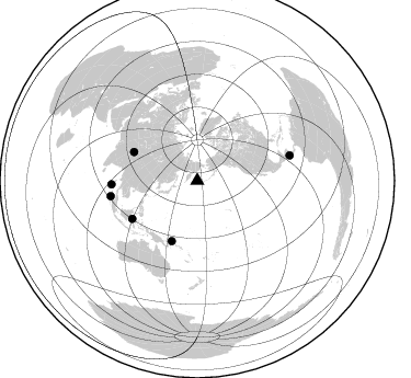
Nearby stations (2 deg radius)

| Station | Name | (Lat, Lon) | Start / End | Elevation |
| ATTU | Attu Island, AK, USA | (52.88, 173.16) | 1965-09-13 / 2499-01-01 | 0.2 km |
| Crust2 Type: | B2,melt affected o.c. and oceanic plateaus, 1 km seds. |
| Thickness Estimate: | 18 km |
| Thickness StdDev: | 0.4 km |
| Vp/Vs Estimate: | 2.07 |
| Vp/Vs StdDev: | 0.03 |
| Vs Estimate: | 2.252 km/s |
| Poisson's Ratio: | 0.35 |
| Peak Value: | 0.09 |
| Assumed Vp: | 4.662 km/s |
| Ps Weight: | 0.33333334 |
| PpPs Weight: | 0.33333334 |
| PsPs Weight: | 0.33333328 |
| Residual Complexity: | 0.266 |
| Nearby stations H: | 17 km +- 1.4 km |
| (2.0 deg) Vp/Vs: | 2.07 +- 0.00 |
3 with match > 90% ( 27.272728 %) and 6 with match > 80% ( 54.545456 %) out of 11.
Download stack as xyz text file.
Azimuth Distribution of Events:
Prior Results for this Station
| Study | Thickness | Vp/Vs | Vp | Vs | Poissons Ratio | Extra |
| EARS | 18 km | 2.07 | 4.662 km/s | 2.252 km/s | 0.35 | |
| Crust2.0 | 16 km | 2.05 | 4.662 km/s | 2.269 km/s | 0.34 | B2,melt affected o.c. and oceanic plateaus, 1 km seds. |
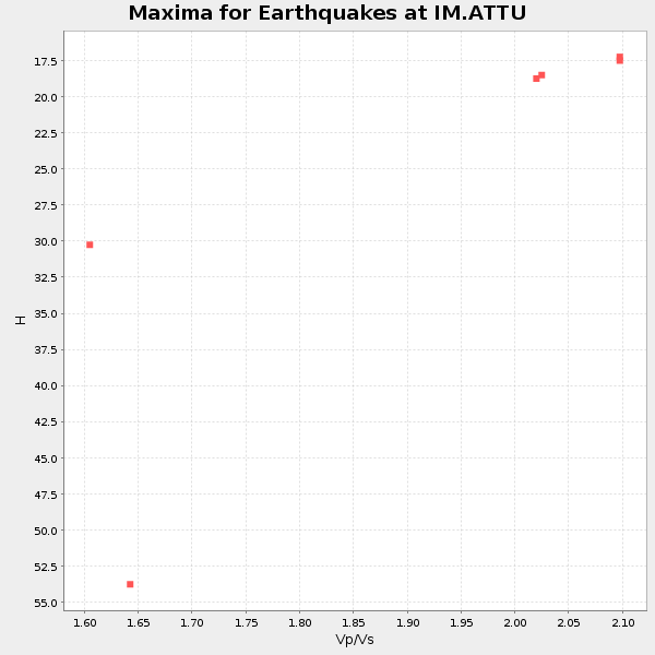
| Global Maxima | 18 km | 2.07 | 4.662 km/s | 2.252 km/s | 0.35 | amp=0.08628318 |
| Local Maxima 1 | 16 km | 2.10 | 4.662 km/s | 2.223 km/s | 0.35 | amp=0.026206162 |
| Local Maxima 2 | 33 km | 1.60 | 4.662 km/s | 2.914 km/s | 0.18 | amp=0.017907584 |
| Local Maxima 3 | 46 km | 1.92 | 4.662 km/s | 2.432 km/s | 0.31 | amp=0.0133217955 |
| Local Maxima 4 | 12 km | 1.66 | 4.662 km/s | 2.8 km/s | 0.22 | amp=0.0117215 |
| Predicted Arrivals for vertical incidence (zero ray parameter) | |
| Ps | 4.02 SECOND |
| PpPs | 11.52 SECOND |
| PsPs/PpSs | 15.54 SECOND |
Events Processed for this Station
Download zip of receiver functions as SAC
Plot maxima for each earthquake.
Events Used in the Stack
(6 events)| Radial Match | Distance | Baz | FERegion | Time | Lat/Lon | Depth | Magnitude |
| 93.20644 | 59.6 deg | 202.924 deg | New Ireland Region, P.N.G. | 2005/09/09 07:26:43 GMT | (-4.5, 153.5) | 90 km | 6.3 MB, 7.7 MW, 7.5 MW |
| 92.61037 | 68.7 deg | 239.708 deg | Minahassa Peninsula, Sulawesi | 1998/05/21 05:34:25 GMT | (0.2, 119.6) | 33 km | 6.2 MB, 6.3 MS, 6.6 UNKNOWN, 6.6 MW |
| 92.253845 | 80.2 deg | 259.939 deg | Northern Sumatra, Indonesia | 2005/07/05 01:52:02 GMT | (1.8, 97.1) | 21 km | 6.2 MB, 6.8 MS, 6.7 MW, 6.6 MW |
| 88.08463 | 78.3 deg | 267.62 deg | Nicobar Islands, India Region | 2005/07/24 15:42:06 GMT | (7.9, 92.2) | 16 km | 6.6 MB, 7.5 MS, 7.3 MW, 7.2 MW |
| 83.72274 | 87.5 deg | 74.807 deg | Near Coast Of Nicaragua | 2005/07/02 02:16:43 GMT | (11.2, -86.2) | 27 km | 5.6 MB, 6.4 MS, 6.6 MW, 6.6 MW |
| 80.40573 | 63.6 deg | 294.37 deg | Southern Xinjiang, China | 2008/03/20 22:32:57 GMT | (35.5, 81.5) | 10 km | 6.3 MB, 7.3 MS, 7.2 MW, 7.1 MW |
Losers
(5 events)| Radial Match | Distance | Baz | FERegion | Time | Lat/Lon | Depth | Magnitude | Reason |
| 74.55747 | 80.8 deg | 256.749 deg | Southern Sumatra, Indonesia | 1998/04/01 17:56:23 GMT | (-0.5, 99.3) | 56 km | 6.2 MB, 6.9 MS, 7.0 UNKNOWN, 6.6 ME | |
| 68.46451 | 83.0 deg | 172.228 deg | Kermadec Islands, New Zealand | 1998/06/20 20:24:45 GMT | (-30.1, -177.9) | 57 km | 5.7 MB, 6.0 UNKNOWN, 6.0 MW | |
| 65.64641 | 75.1 deg | 172.985 deg | South Of Fiji Islands | 1998/05/16 02:22:03 GMT | (-22.2, -179.5) | 586 km | 6.1 MB, 6.8 UNKNOWN | |
| 53.306057 | 87.3 deg | 74.774 deg | Near Coast Of Nicaragua | 2005/07/02 04:11:04 GMT | (11.4, -86.3) | 40 km | 5.4 MB, 5.4 MS, 5.8 MW, 5.0 MD | |
| 42.32307 | 69.0 deg | 226.583 deg | Banda Sea | 1998/06/17 18:49:03 GMT | (-6.0, 130.2) | 148 km | 5.5 MB, 5.7 UNKNOWN, 5.6 MW |
