
Station IU BBSR - Bermuda Institute of Ocean Sciences, St George's Bermuda
Network: IU - Global Seismograph Network (GSN - IRIS/USGS)
Nearby stations (2 deg radius)
| Station | Name | (Lat, Lon) | Start / End | Elevation |
| BBSR | Bermuda Institute of Ocean Sciences, St George's Bermuda | (32.37, -64.70) | 2008-08-01 / 2599-12-31 | 30 m |
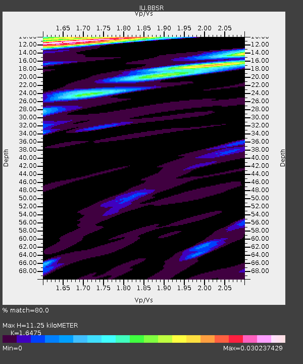
| Crust2 Type: | A1,normal oceanic 0.5 km seds. |
| Thickness Estimate: | 11 km |
| Thickness StdDev: | 6.3 km |
| Vp/Vs Estimate: | 1.65 |
| Vp/Vs StdDev: | 0.17 |
| Vs Estimate: | 2.523 km/s |
| Poisson's Ratio: | 0.21 |
| Peak Value: | 0.03 |
| Assumed Vp: | 4.157 km/s |
| Ps Weight: | 0.33333334 |
| PpPs Weight: | 0.33333334 |
| PsPs Weight: | 0.33333328 |
| Residual Complexity: | 0.692 |
| Nearby stations H: | +- |
| (2.0 deg) Vp/Vs: | +- |
8 with match > 90% ( 27.586206 %) and 15 with match > 80% ( 51.724136 %) out of 29.
Download stack as xyz text file.
Azimuth Distribution of Events:

Prior Results for this Station
| Study | Thickness | Vp/Vs | Vp | Vs | Poissons Ratio | Extra |
| EARS | 11 km | 1.65 | 4.157 km/s | 2.523 km/s | 0.21 | |
| Crust2.0 | 12 km | 2.18 | 4.157 km/s | 1.904 km/s | 0.37 | A1,normal oceanic 0.5 km seds. |
| Global Maxima | 11 km | 1.65 | 4.157 km/s | 2.523 km/s | 0.21 | amp=0.030237429 |
| Local Maxima 1 | 17 km | 2.01 | 4.157 km/s | 2.071 km/s | 0.33 | amp=0.021904403 |
| Local Maxima 2 | 14 km | 2.10 | 4.157 km/s | 1.982 km/s | 0.35 | amp=0.018242735 |
| Local Maxima 3 | 10 km | 1.69 | 4.157 km/s | 2.46 km/s | 0.23 | amp=0.0145586105 |
| Local Maxima 4 | 24 km | 1.72 | 4.157 km/s | 2.42 km/s | 0.24 | amp=0.0143599585 |
| Predicted Arrivals for vertical incidence (zero ray parameter) | |
| Ps | 1.75 SECOND |
| PpPs | 7.17 SECOND |
| PsPs/PpSs | 8.92 SECOND |
Events Processed for this Station
Download zip of receiver functions as SAC
Plot maxima for each earthquake.
Events Used in the Stack
(15 events)| Radial Match | Distance | Baz | FERegion | Time | Lat/Lon | Depth | Magnitude |
| 96.75179 | 74.6 deg | 322.265 deg | Fox Islands, Aleutian Islands | 2011/06/24 03:09:39 UTC | (52.0, -171.8) | 52 km | 6.9 MB, 7.3 MW, 7.3 MW |
| 96.401535 | 56.8 deg | 335.537 deg | Northern Alaska | 2018/08/12 14:58:54 UTC | (69.6, -145.3) | 2.2 km | 6.3 ml |
| 96.06292 | 56.5 deg | 335.463 deg | Northern Alaska | 2018/08/12 21:15:01 UTC | (69.5, -144.4) | 1.7 km | 6.0 Mww |
| 95.15979 | 31.5 deg | 243.709 deg | Near Coast Of Chiapas, Mexico | 2017/09/08 04:49:21 UTC | (15.1, -93.7) | 70 km | 8.1 Mww |
| 95.0333 | 30.3 deg | 241.426 deg | Near Coast Of Chiapas, Mexico | 2017/06/14 07:29:03 UTC | (14.9, -92.0) | 98 km | 7.0 Mi |
| 93.95202 | 60.8 deg | 320.239 deg | Gulf Of Alaska | 2018/01/23 09:31:42 UTC | (56.0, -149.1) | 25 km | 7.9 Mww |
| 93.450264 | 73.3 deg | 321.809 deg | Fox Islands, Aleutian Islands | 2015/07/27 04:49:44 UTC | (52.4, -169.7) | 12 km | 6.9 MO |
| 91.98003 | 80.0 deg | 326.89 deg | Rat Islands, Aleutian Islands | 2017/10/08 22:34:33 UTC | (52.4, 176.8) | 112 km | 6.6 mww |
| 89.22228 | 84.4 deg | 334.29 deg | Near East Coast Of Kamchatka | 2016/03/20 22:50:20 UTC | (54.3, 162.8) | 31 km | 6.4 MWC, 6.2 MWB, 6.6 MI |
| 89.0053 | 47.5 deg | 191.705 deg | Central Peru | 2014/08/24 23:21:45 UTC | (-14.6, -73.6) | 101 km | 6.9 MWW, 6.8 MI, 6.9 MWB |
| 88.33955 | 37.8 deg | 205.098 deg | Near Coast Of Ecuador | 2023/03/18 17:12:53 UTC | (-2.9, -79.8) | 66 km | 6.7 Mww |
| 87.26167 | 62.5 deg | 187.299 deg | Off Coast Of Central Chile | 2019/06/14 00:19:10 UTC | (-30.0, -72.2) | 10 km | 6.5 Mww |
| 86.612465 | 34.8 deg | 207.091 deg | Near Coast Of Ecuador | 2016/05/18 07:57:05 UTC | (0.4, -79.8) | 32 km | 6.7 MWP, 6.7 MWW, 6.7 MI |
| 86.50338 | 29.9 deg | 217.076 deg | South Of Panama | 2014/05/13 06:35:24 UTC | (7.2, -82.3) | 10 km | 6.8 MWP, 6.8 MI |
| 85.026306 | 63.2 deg | 186.448 deg | Near Coast Of Central Chile | 2015/09/26 02:51:18 UTC | (-30.8, -71.4) | 38 km | 6.2 MO |
Losers
(14 events)| Radial Match | Distance | Baz | FERegion | Time | Lat/Lon | Depth | Magnitude | Reason |
| 79.9476 | 74.2 deg | 322.248 deg | Fox Islands, Aleutian Islands | 2018/08/25 16:50:04 UTC | (52.3, -171.2) | 35 km | 5.5 Ml | |
| 78.66571 | 50.8 deg | 186.056 deg | Northern Chile | 2017/10/10 06:32:20 UTC | (-18.5, -69.6) | 82 km | 6.3 Mww | |
| 78.49908 | 58.9 deg | 327.358 deg | Central Alaska | 2021/05/31 06:59:54 UTC | (62.4, -148.3) | 44 km | 6.1 Mww | |
| 73.008675 | 37.1 deg | 205.532 deg | Near Coast Of Ecuador | 2022/07/14 22:30:13 UTC | (-2.1, -79.8) | 81 km | 5.7 mww | |
| 69.8566 | 63.8 deg | 186.188 deg | Near Coast Of Central Chile | 2015/09/22 07:12:59 UTC | (-31.5, -71.2) | 54 km | 6.1 MWB | |
| 66.8984 | 51.2 deg | 185.982 deg | Northern Chile | 2018/01/21 01:06:42 UTC | (-18.9, -69.6) | 111 km | 6.3 Mww | |
| 66.08774 | 42.7 deg | 189.289 deg | Peru-Brazil Border Region | 2015/11/24 22:50:53 UTC | (-10.1, -71.1) | 595 km | 5.9 MB | |
| 65.87123 | 33.7 deg | 249.917 deg | Oaxaca, Mexico | 2018/02/19 06:57:01 UTC | (16.5, -97.6) | 40 km | 5.9 Mww | |
| 64.53806 | 51.9 deg | 185.513 deg | Northern Chile | 2018/11/01 22:19:51 UTC | (-19.6, -69.3) | 102 km | 6.2 Mww | |
| 62.125057 | 31.6 deg | 240.783 deg | Off Coast Of Chiapas, Mexico | 2019/12/23 15:47:56 UTC | (13.8, -92.8) | 10 km | 5.8 Mww | |
| 61.736794 | 43.2 deg | 27.413 deg | Iceland | 2014/09/10 05:28:31 UTC | (64.7, -17.5) | 3.6 km | 5.2 MW | |
| 58.4809 | 72.3 deg | 321.553 deg | Fox Islands, Aleutian Islands | 2021/11/04 08:57:06 UTC | (52.7, -168.0) | 36 km | 5.2 Mww | |
| 56.444023 | 52.1 deg | 184.948 deg | Chile-Bolivia Border Region | 2010/04/05 22:36:57 UTC | (-19.9, -68.8) | 94 km | 5.8 MW, 5.7 MW, 5.8 MB | |
| 51.448948 | 43.7 deg | 24.84 deg | Iceland Region | 2020/06/20 15:05:11 UTC | (66.5, -18.4) | 10 km | 5.4 Mww |

