
Station IU BOCO - Bogota, Colombia
Network: IU - Global Seismograph Network (GSN - IRIS/USGS)
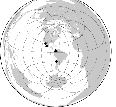
Nearby stations (2 deg radius)
| Station | Name | (Lat, Lon) | Start / End | Elevation |
| BOCO | Bogota, Colombia | (4.59, -74.04) | 1994-06-06 / 1996-03-26 | 3160 m |
| BOCO | Bogota, Colombia | (4.59, -74.04) | 1996-03-26 / 1996-08-22 | 3160 m |
| Crust2 Type: | P6,orogen/43km, Orogen, 0.5 km seds. |
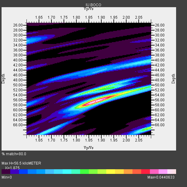
| Thickness Estimate: | 56 km |
| Thickness StdDev: | 12 km |
| Vp/Vs Estimate: | 1.88 |
| Vp/Vs StdDev: | 0.13 |
| Vs Estimate: | 3.387 km/s |
| Poisson's Ratio: | 0.30 |
| Peak Value: | 0.04 |
| Assumed Vp: | 6.35 km/s |
| Ps Weight: | 0.33333334 |
| PpPs Weight: | 0.33333334 |
| PsPs Weight: | 0.33333328 |
| Residual Complexity: | 0.660 |
| Nearby stations H: | +- |
| (2.0 deg) Vp/Vs: | +- |
1 with match > 90% ( 6.6666665 %) and 3 with match > 80% ( 20.0 %) out of 15.
Download stack as xyz text file.
Azimuth Distribution of Events:
Prior Results for this Station
| Study | Thickness | Vp/Vs | Vp | Vs | Poissons Ratio | Extra |
| EARS | 56 km | 1.88 | 6.35 km/s | 3.387 km/s | 0.30 | |
| Crust2.0 | 43 km | 1.76 | 6.35 km/s | 3.609 km/s | 0.26 | P6,orogen/43km, Orogen, 0.5 km seds. |
| Global Maxima | 56 km | 1.88 | 6.35 km/s | 3.387 km/s | 0.30 | amp=0.0440633 |
| Local Maxima 1 | 52 km | 1.88 | 6.35 km/s | 3.378 km/s | 0.30 | amp=0.027957814 |
| Local Maxima 2 | 67 km | 2.10 | 6.35 km/s | 3.031 km/s | 0.35 | amp=0.025885198 |
| Local Maxima 3 | 52 km | 2.01 | 6.35 km/s | 3.159 km/s | 0.34 | amp=0.022848133 |
| Local Maxima 4 | 40 km | 2.10 | 6.35 km/s | 3.027 km/s | 0.35 | amp=0.016056668 |
| Predicted Arrivals for vertical incidence (zero ray parameter) | |
| Ps | 7.79 SECOND |
| PpPs | 25.58 SECOND |
| PsPs/PpSs | 33.37 SECOND |
Events Processed for this Station
Download zip of receiver functions as SAC
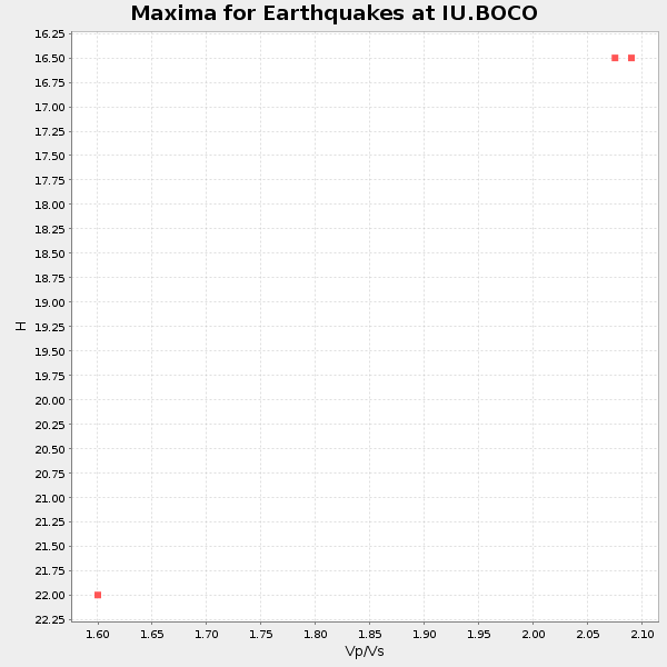
Plot maxima for each earthquake.
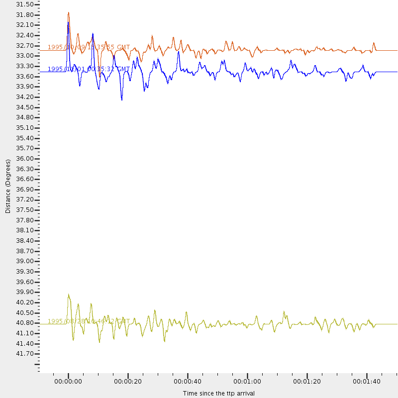
Events Used in the Stack
(3 events)| Radial Match | Distance | Baz | FERegion | Time | Lat/Lon | Depth | Magnitude |
| 91.76649 | 32.8 deg | 298.692 deg | Near Coast Of Jalisco, Mexico | 1995/10/09 15:35:55 GMT | (19.1, -104.2) | 49 km | 6.5 MB, 7.3 MS, 7.3 UNKNOWN, 7.9 MW |
| 83.98384 | 33.4 deg | 175.958 deg | Near Coast Of Central Chile | 1995/11/01 00:35:32 GMT | (-29.0, -71.5) | 20 km | 6.3 MB, 6.4 MS, 6.3 UNKNOWN, 6.7 MW |
| 82.127106 | 40.8 deg | 305.498 deg | Gulf Of California | 1995/08/28 10:46:12 GMT | (26.2, -110.3) | 10 km | 5.6 MB, 6.5 MS |
Losers
(12 events)| Radial Match | Distance | Baz | FERegion | Time | Lat/Lon | Depth | Magnitude | Reason |
| 90.96378 | 70.7 deg | 154.975 deg | South Sandwich Islands Region | 1995/08/18 02:16:26 GMT | (-55.9, -28.9) | 36 km | 5.6 MB, 5.8 MS, 5.7 UNKNOWN, 6.3 MW | |
| 82.1405 | 32.7 deg | 162.16 deg | Santiago Del Estero Prov., Arg. | 1994/08/19 10:02:51 GMT | (-26.7, -63.4) | 565 km | 6.4 MB, 6.5 UNKNOWN, 6.5 MW | |
| 81.35894 | 59.1 deg | 94.509 deg | North Of Ascension Island | 1996/02/16 09:44:58 GMT | (-1.5, -15.2) | 10 km | 6.0 MB, 6.3 MS, 6.5 UNKNOWN, 6.4 MW | |
| 76.70619 | 62.4 deg | 175.113 deg | Drake Passage | 1995/01/03 16:11:59 GMT | (-57.7, -66.0) | 33 km | 6.1 MB, 5.6 MS, 6.1 UNKNOWN, 5.9 MW | |
| 76.596 | 94.4 deg | 322.295 deg | Andreanof Islands, Aleutian Is. | 1996/06/10 15:24:56 GMT | (51.5, -176.8) | 26 km | 5.9 MB, 7.1 MS, 7.2 UNKNOWN, 6.9 MS | |
| 74.1752 | 81.8 deg | 210.976 deg | Pacific-Antarctic Ridge | 1995/08/23 13:14:42 GMT | (-56.8, -141.7) | 10 km | 5.9 MB, 5.6 MS, 5.5 UNKNOWN, 6.2 MW | |
| 71.24408 | 95.1 deg | 322.493 deg | Andreanof Islands, Aleutian Is. | 1996/06/08 23:19:15 GMT | (51.5, -178.1) | 33 km | 5.9 MB, 6.3 MS, 6.5 UNKNOWN, 6.1 MS | |
| 67.05889 | 33.1 deg | 172.159 deg | Chile-Argentina Border Region | 1995/08/03 08:18:53 GMT | (-28.3, -69.2) | 104 km | 5.9 MB, 5.8 UNKNOWN, 5.9 MW | |
| 66.37144 | 43.7 deg | 176.346 deg | Southern Argentina | 1994/10/20 01:15:16 GMT | (-39.2, -70.8) | 164 km | 5.7 MB, 5.9 UNKNOWN, 6.2 MW | |
| 63.92726 | 91.4 deg | 49.727 deg | Greece | 1995/05/13 08:47:12 GMT | (40.1, 21.7) | 13 km | 6.2 MB, 6.5 MS, 6.6 UNKNOWN, 6.5 MD | |
| 52.245743 | 92.2 deg | 322.075 deg | Andreanof Islands, Aleutian Is. | 1995/10/30 20:25:28 GMT | (51.7, -173.4) | 33 km | 5.4 MB, 5.3 MS, 5.8 UNKNOWN, 5.6 ML | |
| 50.47026 | 94.4 deg | 321.989 deg | Andreanof Islands, Aleutian Is. | 1996/06/10 15:36:29 GMT | (51.2, -176.8) | 33 km | 5.5 MB |
