
Station JM MBJB - Montego Bay, Jamaica
Network: JM - Jamaica Seismograph Network
Nearby stations (2 deg radius)
| Station | Name | (Lat, Lon) | Start / End | Elevation |
| MBJB | Montego Bay, Jamaica | (18.41, -77.86) | 2013-01-01 / 2599-12-31 | 554 m |
| Crust2 Type: | B2,melt affected o.c. and oceanic plateaus, 1 km seds. |
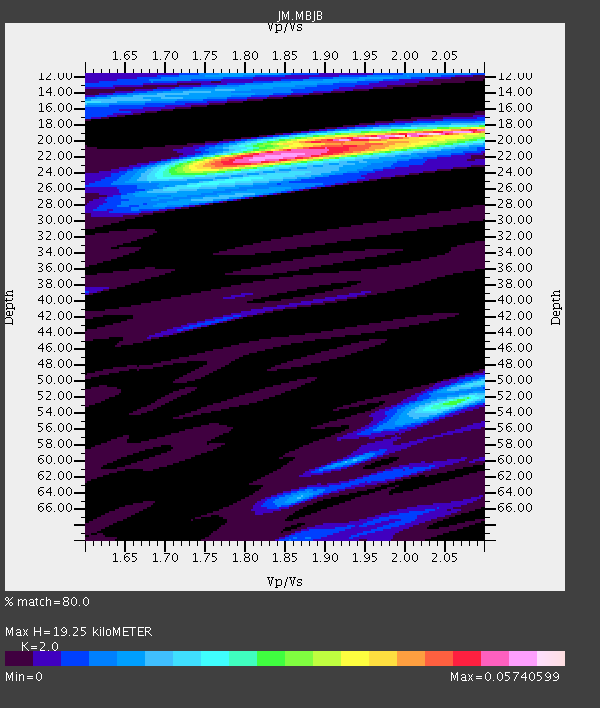
| Thickness Estimate: | 19 km |
| Thickness StdDev: | 1.1 km |
| Vp/Vs Estimate: | 2.00 |
| Vp/Vs StdDev: | 0.08 |
| Vs Estimate: | 2.331 km/s |
| Poisson's Ratio: | 0.33 |
| Peak Value: | 0.06 |
| Assumed Vp: | 4.662 km/s |
| Ps Weight: | 0.33333334 |
| PpPs Weight: | 0.33333334 |
| PsPs Weight: | 0.33333328 |
| Residual Complexity: | 0.675 |
| Nearby stations H: | +- |
| (2.0 deg) Vp/Vs: | +- |
1 with match > 90% ( 3.8461537 %) and 7 with match > 80% ( 26.923077 %) out of 26.
Download stack as xyz text file.
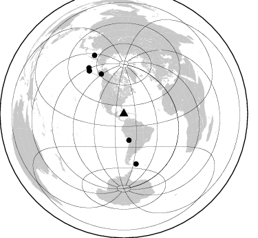
Azimuth Distribution of Events:
Prior Results for this Station
| Study | Thickness | Vp/Vs | Vp | Vs | Poissons Ratio | Extra |
| EARS | 19 km | 2.00 | 4.662 km/s | 2.331 km/s | 0.33 | |
| Crust2.0 | 16 km | 2.05 | 4.662 km/s | 2.269 km/s | 0.34 | B2,melt affected o.c. and oceanic plateaus, 1 km seds. |
| Global Maxima | 19 km | 2.00 | 4.662 km/s | 2.331 km/s | 0.33 | amp=0.05740599 |
| Local Maxima 1 | 22 km | 1.82 | 4.662 km/s | 2.562 km/s | 0.28 | amp=0.04846257 |
| Local Maxima 2 | 52 km | 2.07 | 4.662 km/s | 2.255 km/s | 0.35 | amp=0.025800785 |
| Local Maxima 3 | 24 km | 1.75 | 4.662 km/s | 2.664 km/s | 0.26 | amp=0.019096145 |
| Local Maxima 4 | 15 km | 1.61 | 4.662 km/s | 2.9 km/s | 0.18 | amp=0.018604826 |
| Predicted Arrivals for vertical incidence (zero ray parameter) | |
| Ps | 4.13 SECOND |
| PpPs | 12.39 SECOND |
| PsPs/PpSs | 16.52 SECOND |
Events Processed for this Station
Download zip of receiver functions as SAC
Plot maxima for each earthquake.
Events Used in the Stack
(7 events)| Radial Match | Distance | Baz | FERegion | Time | Lat/Lon | Depth | Magnitude |
| 91.15866 | 80.3 deg | 321.063 deg | Andreanof Islands, Aleutian Is. | 2013/08/30 16:25:02 GMT | (51.5, -175.2) | 29 km | 7.0 MWW, 6.5 ML, 6.8 MI, 6.9 MWC, 6.9 MWB, 7.0 MWW, 7.0 MI, 7.0 MWC |
| 86.56451 | 38.7 deg | 169.088 deg | Near Coast Of Northern Chile | 2014/03/16 21:16:30 GMT | (-19.9, -70.6) | 20 km | 6.7 MWW, 6.7 MWC, 7.0 MI |
| 86.41052 | 66.4 deg | 330.281 deg | Southern Alaska | 2014/09/25 17:51:17 GMT | (62.0, -151.8) | 103 km | 6.2 ML, 6.1 MI, 6.2 MWW, 6.3 MWR, 6.3 MWB, 6.3 MWC |
| 86.23484 | 83.7 deg | 322.568 deg | Rat Islands, Aleutian Islands | 2014/06/23 20:53:09 GMT | (51.8, 178.8) | 108 km | 7.9 MWW, 7.1 MI, 7.9 MWC |
| 85.193146 | 80.0 deg | 320.997 deg | Andreanof Islands, Aleutian Is. | 2013/09/04 02:32:30 GMT | (51.6, -174.8) | 20 km | 6.5 MWW, 5.9 ML, 6.3 MWB, 6.5 MI, 6.5 MWC, 6.5 MWW |
| 83.86485 | 95.1 deg | 333.176 deg | Sea Of Okhotsk | 2013/05/24 05:44:48 GMT | (54.9, 153.2) | 598 km | 8.4 MW, 7.5 MB, 8.3 MW |
| 82.98954 | 74.7 deg | 166.226 deg | Falkland Islands Region | 2013/11/25 06:27:33 GMT | (-53.9, -55.0) | 12 km | 7.0 MWW, 6.9 MWC, 6.9 MWB, 7.0 MWC |
Losers
(19 events)| Radial Match | Distance | Baz | FERegion | Time | Lat/Lon | Depth | Magnitude | Reason |
| 79.515175 | 30.9 deg | 290.161 deg | Gulf Of California | 2013/10/19 17:54:54 GMT | (26.1, -110.3) | 9.5 km | 6.6 MWW, 6.5 MWB, 6.6 MWC, 6.6 MWW, 6.8 MI | |
| 73.8847 | 50.4 deg | 320.226 deg | Vancouver Island, Canada Region | 2014/04/24 03:10:13 GMT | (49.8, -127.4) | 11 km | 6.7 MWP, 6.7 MI | |
| 72.75348 | 88.2 deg | 53.218 deg | Crete, Greece | 2013/10/12 13:11:53 GMT | (35.5, 23.3) | 40 km | 6.6 MWW, 6.5 MWB, 6.6 MWW, 6.7 MWC | |
| 71.892075 | 52.5 deg | 321.079 deg | Queen Charlotte Islands Region | 2013/09/04 00:23:11 GMT | (51.2, -130.2) | 9.9 km | 6.0 MW, 5.9 MI, 5.9 MWR, 6.0 MWW, 6.0 MWW, 6.0 MWC | |
| 70.28912 | 80.2 deg | 320.719 deg | Andreanof Islands, Aleutian Is. | 2013/08/31 06:38:36 GMT | (51.2, -174.9) | 18 km | 6.0 MWW, 5.5 ML, 5.9 MWB, 5.9 MWC, 6.0 MWC, 6.0 MI, 6.0 MWW | |
| 67.12255 | 34.9 deg | 97.694 deg | Northern Mid-Atlantic Ridge | 2013/06/24 22:04:13 GMT | (10.7, -42.6) | 10 km | 6.5 MW, 6.1 MB, 6.3 MS, 6.6 MW | |
| 66.87579 | 43.4 deg | 164.859 deg | Jujuy Province, Argentina | 2014/09/24 11:16:12 GMT | (-23.9, -66.6) | 189 km | 6.2 MWP, 6.2 MWB, 6.2 MWC | |
| 66.23366 | 39.4 deg | 169.458 deg | Near Coast Of Northern Chile | 2014/04/04 01:37:51 GMT | (-20.6, -70.7) | 20 km | 6.1 MWP, 6.1 MWB, 6.1 MWW, 6.3 MWC | |
| 66.08597 | 88.1 deg | 154.396 deg | South Sandwich Islands Region | 2013/07/26 21:32:59 GMT | (-57.9, -23.8) | 13 km | 6.2 MW, 6.0 MS, 6.2 MB, 6.3 MW | |
| 64.78532 | 33.1 deg | 172.379 deg | Central Peru | 2014/08/24 23:21:45 GMT | (-14.6, -73.6) | 101 km | 6.9 MWW, 6.8 MI, 6.9 MWB | |
| 64.079544 | 80.0 deg | 321.017 deg | Andreanof Islands, Aleutian Is. | 2013/09/04 06:16:49 GMT | (51.6, -174.8) | 21 km | 5.7 MWW, 5.5 ML, 5.5 MI, 5.7 MWB, 5.7 MWW, 5.8 MWC | |
| 63.796444 | 80.0 deg | 321.029 deg | Andreanof Islands, Aleutian Is. | 2013/09/04 06:27:03 GMT | (51.6, -174.9) | 17 km | 6.0 MWW, 5.5 ML, 5.9 MWB, 6.0 MWW, 6.1 MWC, 6.1 MI | |
| 62.00876 | 57.2 deg | 219.635 deg | Easter Island Region | 2014/09/03 20:34:00 GMT | (-26.5, -114.6) | 10 km | 5.9 MWB | |
| 61.601414 | 57.1 deg | 219.438 deg | Easter Island Region | 2014/09/06 06:53:13 GMT | (-26.6, -114.5) | 10 km | 6.1 MB | |
| 60.96566 | 82.7 deg | 321.535 deg | Andreanof Islands, Aleutian Is. | 2014/03/13 13:20:59 GMT | (51.2, -179.1) | 26 km | 5.6 MWC, 5.1 ML, 5.4 MWW, 5.4 MWB, 5.5 ML, 5.6 MWC | |
| 55.300842 | 49.8 deg | 56.066 deg | Azores Islands Region | 2013/04/30 06:25:23 GMT | (37.6, -24.9) | 10 km | 5.8 MW, 5.9 MW, 5.9 MB | |
| 47.56187 | 58.5 deg | 328.705 deg | Southeastern Alaska | 2014/06/04 11:58:58 GMT | (59.0, -136.7) | 10 km | 5.7 MWP, 5.8 ML, 5.8 MI | |
| 47.427704 | 58.5 deg | 327.897 deg | Southeastern Alaska | 2014/07/25 10:54:49 GMT | (58.4, -137.1) | 10 km | 5.9 MWP | |
| 41.19876 | 34.4 deg | 169.517 deg | Southern Peru | 2013/07/17 02:37:43 GMT | (-15.7, -71.7) | 7.0 km | 6.0 MW, 5.6 MB, 5.8 MS, 5.8 MW |

