
Station K5 TRON - Trongsa Seismic Station
Network: K5 - Bhutan Seismic Network
Nearby stations (2 deg radius)
| Station | Name | (Lat, Lon) | Start / End | Elevation |
| TRON | Trongsa Seismic Station | (27.50, 90.51) | 2017-06-22 / 2599-12-31 | 2260 m |
| Crust2 Type: | R2,orogen/65km Bolivia, 0.5 km seds. |
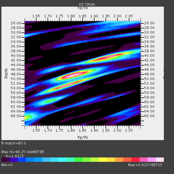
| Thickness Estimate: | 48 km |
| Thickness StdDev: | 6.5 km |
| Vp/Vs Estimate: | 1.81 |
| Vp/Vs StdDev: | 0.09 |
| Vs Estimate: | 3.576 km/s |
| Poisson's Ratio: | 0.28 |
| Peak Value: | 0.02 |
| Assumed Vp: | 6.481 km/s |
| Ps Weight: | 0.33333334 |
| PpPs Weight: | 0.33333334 |
| PsPs Weight: | 0.33333328 |
| Residual Complexity: | 0.703 |
| Nearby stations H: | +- |
| (2.0 deg) Vp/Vs: | +- |
2 with match > 90% ( 6.060606 %) and 12 with match > 80% ( 36.363636 %) out of 33.
Download stack as xyz text file.
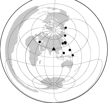
Azimuth Distribution of Events:
Prior Results for this Station
| Study | Thickness | Vp/Vs | Vp | Vs | Poissons Ratio | Extra |
| EARS | 48 km | 1.81 | 6.481 km/s | 3.576 km/s | 0.28 | |
| Crust2.0 | 65 km | 1.76 | 6.481 km/s | 3.685 km/s | 0.26 | R2,orogen/65km Bolivia, 0.5 km seds. |
| Global Maxima | 48 km | 1.81 | 6.481 km/s | 3.576 km/s | 0.28 | amp=0.015748715 |
| Local Maxima 1 | 52 km | 1.80 | 6.481 km/s | 3.605 km/s | 0.28 | amp=0.01280695 |
| Local Maxima 2 | 40 km | 1.97 | 6.481 km/s | 3.286 km/s | 0.33 | amp=0.012218151 |
| Local Maxima 3 | 67 km | 1.60 | 6.481 km/s | 4.05 km/s | 0.18 | amp=0.00784936 |
| Local Maxima 4 | 25 km | 1.97 | 6.481 km/s | 3.29 km/s | 0.33 | amp=0.0060478537 |
| Predicted Arrivals for vertical incidence (zero ray parameter) | |
| Ps | 6.05 SECOND |
| PpPs | 20.94 SECOND |
| PsPs/PpSs | 26.99 SECOND |
Events Processed for this Station
Download zip of receiver functions as SAC
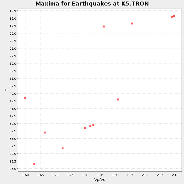
Plot maxima for each earthquake.
Events Used in the Stack
(12 events)| Radial Match | Distance | Baz | FERegion | Time | Lat/Lon | Depth | Magnitude |
| 93.452385 | 53.3 deg | 297.067 deg | Dodecanese Islands, Greece | 2017/07/20 22:31:12 GMT | (36.9, 27.5) | 10 km | 6.7 Mww |
| 90.989365 | 82.7 deg | 29.201 deg | Gulf Of Alaska | 2018/01/23 09:31:42 GMT | (56.0, -149.1) | 25 km | 7.9 Mww |
| 88.7974 | 44.3 deg | 58.251 deg | Hokkaido, Japan Region | 2018/01/24 10:51:20 GMT | (41.1, 142.3) | 40 km | 6.2 Mww |
| 88.60341 | 36.2 deg | 57.612 deg | Sea Of Japan | 2017/07/12 19:48:07 GMT | (40.9, 131.6) | 538 km | 5.8 Mww |
| 87.59512 | 35.9 deg | 110.241 deg | Leyte, Philippines | 2017/07/06 08:03:57 GMT | (11.1, 124.6) | 6.5 km | 6.5 mww |
| 85.94347 | 53.6 deg | 92.763 deg | South Of Mariana Islands | 2018/02/13 01:11:43 GMT | (13.9, 146.4) | 12 km | 5.4 mb |
| 84.98634 | 43.8 deg | 63.573 deg | Near East Coast Of Honshu, Japan | 2017/07/20 00:11:25 GMT | (37.4, 141.6) | 35 km | 5.8 Mww |
| 84.59641 | 53.9 deg | 92.646 deg | South Of Mariana Islands | 2018/02/13 02:03:03 GMT | (13.8, 146.7) | 10 km | 5.7 mww |
| 83.52966 | 60.0 deg | 39.718 deg | Komandorskiye Ostrova Region | 2018/01/25 02:10:33 GMT | (55.4, 166.5) | 8.8 km | 6.2 Mww |
| 82.552 | 66.8 deg | 107.596 deg | New Ireland Region, P.N.G. | 2018/02/10 22:50:48 GMT | (-3.8, 151.9) | 268 km | 5.8 Mww |
| 82.00888 | 45.2 deg | 59.779 deg | Off East Coast Of Honshu, Japan | 2017/07/23 15:35:40 GMT | (40.0, 143.5) | 10 km | 5.6 Mww |
| 81.238495 | 53.7 deg | 92.724 deg | South Of Mariana Islands | 2018/02/11 23:14:18 GMT | (13.8, 146.5) | 42 km | 6.2 Mi |
Losers
(21 events)| Radial Match | Distance | Baz | FERegion | Time | Lat/Lon | Depth | Magnitude | Reason |
| 90.81346 | 60.6 deg | 115.466 deg | New Guinea, Papua New Guinea | 2018/02/25 17:44:39 GMT | (-6.2, 142.8) | 10 km | 7.6 Mi | |
| 85.995094 | 61.6 deg | 110.978 deg | Near N Coast Of New Guinea, P.N.G. | 2018/01/26 22:47:57 GMT | (-3.5, 145.8) | 10 km | 6.3 Mww | |
| 81.40515 | 60.7 deg | 113.201 deg | Near N Coast Of New Guinea, P.N.G. | 2018/01/16 13:02:07 GMT | (-4.7, 144.1) | 76 km | 5.3 Mww | |
| 80.66034 | 82.6 deg | 28.621 deg | Gulf Of Alaska | 2018/01/24 00:04:48 GMT | (56.5, -148.5) | 10 km | 5.5 Mww | |
| 79.72687 | 68.4 deg | 107.785 deg | New Ireland Region, P.N.G. | 2017/07/13 03:36:09 GMT | (-4.8, 153.2) | 47 km | 6.4 mww | |
| 78.16993 | 50.6 deg | 51.421 deg | Kuril Islands | 2017/07/30 21:00:49 GMT | (46.2, 151.0) | 87 km | 5.7 mb | |
| 77.7673 | 31.2 deg | 109.37 deg | Luzon, Philippines | 2017/08/11 05:28:25 GMT | (14.0, 120.7) | 168 km | 6.2 Mww | |
| 76.011345 | 53.0 deg | 123.107 deg | Tanimbar Islands Reg., Indonesia | 2018/01/18 17:48:39 GMT | (-6.4, 132.8) | 27 km | 5.6 Mww | |
| 75.355286 | 60.4 deg | 115.381 deg | New Guinea, Papua New Guinea | 2018/02/26 18:28:03 GMT | (-6.0, 142.7) | 20 km | 5.4 Mww | |
| 74.868225 | 43.9 deg | 63.327 deg | Near East Coast Of Honshu, Japan | 2018/02/25 16:28:39 GMT | (37.6, 141.7) | 31 km | 5.6 Mww | |
| 74.05445 | 43.9 deg | 78.7 deg | Bonin Islands, Japan Region | 2018/02/05 20:56:22 GMT | (27.0, 140.2) | 465 km | 5.3 Mww | |
| 72.37388 | 38.8 deg | 290.535 deg | Iran-Iraq Border Region | 2018/01/11 06:59:31 GMT | (33.8, 45.7) | 10 km | 5.5 Mww | |
| 71.74977 | 39.4 deg | 116.096 deg | Mindanao, Philippines | 2017/08/05 00:30:41 GMT | (6.2, 125.5) | 74 km | 5.8 Mww | |
| 70.77825 | 78.2 deg | 108.132 deg | Solomon Islands | 2017/08/06 00:15:10 GMT | (-10.3, 161.5) | 73 km | 5.7 Mww | |
| 70.74628 | 40.5 deg | 126.393 deg | Minahassa Peninsula, Sulawesi | 2017/07/15 12:12:21 GMT | (0.4, 122.0) | 114 km | 5.9 Mww | |
| 70.60557 | 43.2 deg | 123.847 deg | Southern Molucca Sea | 2018/02/02 00:20:42 GMT | (-0.2, 125.2) | 38 km | 5.5 Mww | |
| 68.29933 | 51.0 deg | 125.011 deg | Banda Sea | 2018/03/02 02:20:12 GMT | (-6.2, 130.3) | 137 km | 5.9 Mww | |
| 67.47553 | 38.8 deg | 290.469 deg | Iran-Iraq Border Region | 2018/01/11 08:00:39 GMT | (33.7, 45.7) | 10 km | 5.3 Mww | |
| 66.94858 | 66.8 deg | 109.711 deg | New Britain Region, P.N.G. | 2017/12/29 23:55:54 GMT | (-5.4, 150.8) | 90 km | 5.7 Mww | |
| 61.834076 | 61.3 deg | 40.488 deg | Komandorskiye Ostrova Region | 2017/07/17 11:05:08 GMT | (54.6, 168.6) | 7.9 km | 6.2 Mww | |
| 58.829723 | 62.9 deg | 348.458 deg | Greenland Sea | 2018/02/08 02:29:14 GMT | (79.8, 2.0) | 10 km | 5.6 Mww |

