
Station KS SEO3 - Seoul, South Korea
Network: KS - Korea National Seismograph Network- KMA
Nearby stations (2 deg radius)
| Station | Name | (Lat, Lon) | Start / End | Elevation |
| SEO3 | Seoul, South Korea | (37.49, 126.92) | 2019-12-06 / 2499-01-01 | 113 m |
| Crust2 Type: | G1,Archean, no seds. |
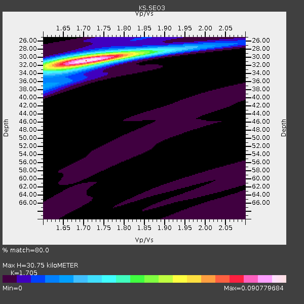
| Thickness Estimate: | 31 km |
| Thickness StdDev: | 0.1 km |
| Vp/Vs Estimate: | 1.71 |
| Vp/Vs StdDev: | 0.01 |
| Vs Estimate: | 3.789 km/s |
| Poisson's Ratio: | 0.24 |
| Peak Value: | 0.09 |
| Assumed Vp: | 6.459 km/s |
| Ps Weight: | 0.33333334 |
| PpPs Weight: | 0.33333334 |
| PsPs Weight: | 0.33333328 |
| Residual Complexity: | 0.251 |
| Nearby stations H: | 30 km +- 0.7 km |
| (2.0 deg) Vp/Vs: | 1.72 +- 0.01 |
25 with match > 90% ( 18.796993 %) and 52 with match > 80% ( 39.097744 %) out of 133.
Download stack as xyz text file.
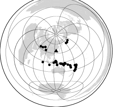
Azimuth Distribution of Events:
Prior Results for this Station
| Study | Thickness | Vp/Vs | Vp | Vs | Poissons Ratio | Extra |
| EARS | 31 km | 1.71 | 6.459 km/s | 3.789 km/s | 0.24 | |
| Crust2.0 | 37 km | 1.76 | 6.459 km/s | 3.665 km/s | 0.26 | G1,Archean, no seds. |
| Global Maxima | 31 km | 1.71 | 6.459 km/s | 3.789 km/s | 0.24 | amp=0.090779684 |
| Local Maxima 1 | 30 km | 1.70 | 6.459 km/s | 3.794 km/s | 0.24 | amp=0.030494364 |
| Local Maxima 2 | 38 km | 1.60 | 6.459 km/s | 4.037 km/s | 0.18 | amp=0.015705522 |
| Local Maxima 3 | 32 km | 1.69 | 6.459 km/s | 3.834 km/s | 0.23 | amp=0.011610107 |
| Local Maxima 4 | 25 km | 1.77 | 6.459 km/s | 3.655 km/s | 0.26 | amp=0.0061917137 |
| Predicted Arrivals for vertical incidence (zero ray parameter) | |
| Ps | 3.36 SECOND |
| PpPs | 12.88 SECOND |
| PsPs/PpSs | 16.23 SECOND |
Events Processed for this Station
Download zip of receiver functions as SAC
Plot maxima for each earthquake.
Events Used in the Stack
(52 events)| Radial Match | Distance | Baz | FERegion | Time | Lat/Lon | Depth | Magnitude |
| 98.659836 | 43.8 deg | 175.911 deg | Banda Sea | 2023/11/08 04:52:52 UTC | (-6.5, 129.8) | 10 km | 6.9 Mi |
| 98.33977 | 43.5 deg | 175.669 deg | Banda Sea | 2023/11/08 13:02:06 UTC | (-6.1, 129.9) | 10 km | 6.7 mww |
| 96.89542 | 64.9 deg | 135.509 deg | Vanuatu Islands | 2023/11/22 04:47:31 UTC | (-15.0, 168.0) | 13 km | 6.7 mww |
| 96.43123 | 77.8 deg | 123.932 deg | Tonga Islands | 2023/07/02 10:27:45 UTC | (-17.9, -174.7) | 247 km | 6.7 Mi |
| 96.35837 | 44.0 deg | 156.561 deg | New Guinea, Papua New Guinea | 2024/03/23 20:22:07 UTC | (-4.1, 143.0) | 64 km | 7.0 Mi |
| 96.30618 | 50.7 deg | 45.91 deg | Alaska Peninsula | 2023/07/16 06:48:21 UTC | (54.5, -160.8) | 21 km | 7.3 Mi |
| 95.71596 | 46.5 deg | 153.139 deg | Eastern New Guinea Reg., P.N.G. | 2023/10/07 08:34:26 UTC | (-5.6, 146.1) | 53 km | 6.7 mww |
| 95.67772 | 48.1 deg | 148.147 deg | New Britain Region, P.N.G. | 2024/05/14 17:15:48 UTC | (-5.6, 150.2) | 121 km | 5.6 mww |
| 95.20174 | 64.7 deg | 135.408 deg | Vanuatu Islands | 2023/07/26 12:44:35 UTC | (-14.8, 167.9) | 13 km | 6.4 mww |
| 94.592155 | 70.2 deg | 137.96 deg | Vanuatu Islands | 2023/12/07 12:56:30 UTC | (-20.7, 169.2) | 48 km | 7.1 Mww |
| 94.27389 | 34.6 deg | 179.688 deg | Northern Molucca Sea | 2024/04/09 09:48:01 UTC | (2.7, 127.1) | 35 km | 6.6 mww |
| 93.985085 | 37.1 deg | 291.228 deg | Kyrgyzstan-Xinjiang Border Reg. | 2024/01/22 18:09:04 UTC | (41.3, 78.6) | 13 km | 7.0 Mww |
| 93.42007 | 51.6 deg | 287.643 deg | Northwestern Afghanistan | 2023/10/15 03:36:00 UTC | (34.6, 62.1) | 8.2 km | 6.3 Mww |
| 93.15556 | 84.5 deg | 132.981 deg | Kermadec Islands Region | 2024/05/31 15:54:41 UTC | (-29.0, -176.9) | 20 km | 6.2 mww |
| 92.96847 | 48.6 deg | 147.112 deg | New Britain Region, P.N.G. | 2024/04/14 20:56:28 UTC | (-5.8, 151.1) | 49 km | 6.5 mww |
| 92.74065 | 86.0 deg | 137.025 deg | South Of Kermadec Islands | 2023/09/08 09:09:58 UTC | (-32.7, -179.3) | 90 km | 6.6 mww |
| 92.54229 | 81.1 deg | 128.682 deg | Tonga Islands Region | 2023/06/16 08:11:34 UTC | (-23.6, -175.9) | 22 km | 6.0 mww |
| 91.950264 | 36.2 deg | 179.048 deg | Halmahera, Indonesia | 2023/09/11 12:51:34 UTC | (1.1, 127.5) | 163 km | 6.0 mww |
| 91.21391 | 31.8 deg | 183.581 deg | Mindanao, Philippines | 2023/11/17 08:14:11 UTC | (5.6, 125.0) | 64 km | 6.7 Mww |
| 90.68892 | 78.7 deg | 125.088 deg | Tonga Islands | 2024/05/26 20:47:09 UTC | (-19.4, -174.9) | 112 km | 6.6 mww |
| 90.408134 | 47.3 deg | 144.693 deg | New Ireland Region, P.N.G. | 2024/05/18 14:04:44 UTC | (-3.8, 152.1) | 10 km | 5.7 mww |
| 90.40572 | 84.9 deg | 134.053 deg | Kermadec Islands, New Zealand | 2023/10/23 10:10:15 UTC | (-29.9, -177.5) | 23 km | 6.0 Mww |
| 90.30318 | 45.1 deg | 50.3 deg | Fox Islands, Aleutian Islands | 2024/05/19 09:35:24 UTC | (52.2, -170.9) | 28 km | 6.0 mww |
| 90.137596 | 48.5 deg | 147.696 deg | New Britain Region, P.N.G. | 2024/03/13 15:13:23 UTC | (-5.9, 150.6) | 50 km | 6.0 mww |
| 90.06305 | 51.6 deg | 287.591 deg | Northwestern Afghanistan | 2023/10/11 00:41:56 UTC | (34.6, 62.1) | 10 km | 6.3 Mww |
| 89.941444 | 74.7 deg | 126.78 deg | Fiji Islands Region | 2023/10/31 11:10:56 UTC | (-17.5, -179.0) | 548 km | 6.4 mww |
| 89.888695 | 41.4 deg | 50.279 deg | Andreanof Islands, Aleutian Is. | 2023/10/16 11:35:31 UTC | (52.4, -176.9) | 187 km | 6.4 Mww |
| 89.833725 | 35.5 deg | 179.571 deg | Halmahera, Indonesia | 2023/11/22 02:48:51 UTC | (1.8, 127.2) | 102 km | 6.0 Mww |
| 88.174576 | 78.2 deg | 124.968 deg | Tonga Islands | 2024/01/18 22:12:20 UTC | (-18.9, -175.1) | 218 km | 6.4 Mww |
| 88.016464 | 34.2 deg | 179.333 deg | Talaud Islands, Indonesia | 2024/06/15 13:08:12 UTC | (3.2, 127.3) | 28 km | 5.6 mww |
| 87.79727 | 48.9 deg | 144.816 deg | New Britain Region, P.N.G. | 2023/09/28 19:21:17 UTC | (-5.3, 152.8) | 49 km | 5.7 Mww |
| 87.3704 | 77.8 deg | 124.674 deg | Tonga Islands | 2023/05/27 00:11:00 UTC | (-18.5, -175.2) | 215 km | 6.0 mww |
| 86.945404 | 37.9 deg | 191.689 deg | Minahassa Peninsula, Sulawesi | 2023/09/09 14:43:24 UTC | (0.0, 119.8) | 9.9 km | 6.0 mww |
| 86.939186 | 55.5 deg | 230.866 deg | South Indian Ocean | 2023/11/14 07:00:56 UTC | (-4.0, 87.1) | 10 km | 6.1 mww |
| 86.742455 | 51.1 deg | 152.019 deg | Eastern New Guinea Reg., P.N.G. | 2023/11/21 07:10:15 UTC | (-9.6, 148.6) | 10 km | 5.5 mww |
| 86.71871 | 32.9 deg | 276.622 deg | Xizang | 2024/06/01 00:46:37 UTC | (34.2, 86.4) | 13 km | 5.6 mb |
| 85.88656 | 63.6 deg | 135.523 deg | Vanuatu Islands | 2023/08/16 12:47:40 UTC | (-13.9, 167.2) | 193 km | 6.5 Mww |
| 85.71825 | 48.9 deg | 206.194 deg | Java, Indonesia | 2024/04/27 16:29:51 UTC | (-8.1, 107.3) | 68 km | 6.1 mww |
| 85.14198 | 57.1 deg | 139.03 deg | Solomon Islands | 2024/04/12 15:59:18 UTC | (-10.2, 160.9) | 42 km | 5.8 Mww |
| 84.7278 | 69.9 deg | 137.854 deg | Vanuatu Islands | 2023/12/24 02:00:31 UTC | (-20.4, 169.1) | 10 km | 5.8 mb |
| 84.12849 | 85.0 deg | 133.881 deg | Kermadec Islands, New Zealand | 2024/02/09 10:57:48 UTC | (-29.9, -177.3) | 10 km | 6.1 mww |
| 83.84207 | 42.1 deg | 161.39 deg | Irian Jaya, Indonesia | 2023/12/30 17:16:23 UTC | (-3.2, 139.3) | 10 km | 6.5 Mi |
| 83.45393 | 33.0 deg | 180.783 deg | Talaud Islands, Indonesia | 2024/06/12 17:01:20 UTC | (4.4, 126.5) | 34 km | 5.8 Mww |
| 83.409294 | 48.5 deg | 143.848 deg | New Ireland Region, P.N.G. | 2023/09/29 01:19:37 UTC | (-4.6, 153.2) | 57 km | 5.5 Mww |
| 82.50217 | 81.6 deg | 128.823 deg | South Of Tonga Islands | 2023/06/25 07:16:59 UTC | (-24.0, -175.6) | 7.1 km | 6.0 mww |
| 82.12094 | 35.4 deg | 184.796 deg | Minahassa Peninsula, Sulawesi | 2023/11/15 23:26:15 UTC | (2.0, 124.1) | 303 km | 5.7 Mww |
| 82.003334 | 65.3 deg | 136.106 deg | Vanuatu Islands | 2023/09/28 14:40:26 UTC | (-15.6, 167.7) | 126 km | 6.0 mww |
| 81.68538 | 49.7 deg | 143.369 deg | Solomon Islands | 2024/06/09 16:28:38 UTC | (-5.4, 154.1) | 125 km | 5.7 Mww |
| 81.518974 | 37.1 deg | 291.079 deg | Kyrgyzstan-Xinjiang Border Reg. | 2024/01/29 22:27:41 UTC | (41.2, 78.7) | 10 km | 5.7 mww |
| 80.691696 | 32.0 deg | 181.611 deg | Mindanao, Philippines | 2023/10/04 11:21:48 UTC | (5.3, 126.1) | 122 km | 6.4 mww |
| 80.38318 | 44.5 deg | 176.038 deg | Banda Sea | 2023/09/22 14:59:17 UTC | (-7.1, 129.7) | 161 km | 5.7 mww |
| 80.36695 | 44.4 deg | 286.634 deg | Hindu Kush Region, Afghanistan | 2024/01/11 09:20:26 UTC | (36.5, 70.6) | 207 km | 6.4 Mww |
Losers
(81 events)| Radial Match | Distance | Baz | FERegion | Time | Lat/Lon | Depth | Magnitude | Reason |
| 97.692024 | 80.2 deg | 128.72 deg | South Of Fiji Islands | 2023/06/15 18:06:29 UTC | (-22.9, -176.6) | 206 km | 7.0 Mi | |
| 97.54519 | 43.8 deg | 176.485 deg | Banda Sea | 2023/11/08 04:53:51 UTC | (-6.5, 129.4) | 10 km | 7.0 Mww | |
| 96.07936 | 81.4 deg | 128.722 deg | Tonga Islands Region | 2023/06/18 15:04:49 UTC | (-23.8, -175.7) | 10 km | 5.8 Mww | |
| 92.883865 | 76.7 deg | 120.545 deg | Samoa Islands Region | 2023/06/17 18:45:00 UTC | (-14.8, -173.0) | 10 km | 6.2 Mi | |
| 90.49959 | 32.5 deg | 181.1 deg | Talaud Islands, Indonesia | 2024/01/08 20:48:46 UTC | (4.9, 126.3) | 91 km | 7.0 Mi | |
| 79.67902 | 52.3 deg | 142.399 deg | Solomon Islands | 2023/07/09 00:06:26 UTC | (-7.4, 156.1) | 35 km | 5.5 mww | |
| 79.122696 | 44.9 deg | 227.349 deg | Off W Coast Of Northern Sumatra | 2024/05/28 11:52:39 UTC | (2.8, 95.6) | 18 km | 5.9 mww | |
| 78.65106 | 45.1 deg | 194.615 deg | Bali Sea | 2023/08/28 19:55:31 UTC | (-6.8, 116.5) | 514 km | 7.1 Mww | |
| 77.456 | 51.7 deg | 287.706 deg | Northwestern Afghanistan | 2023/10/07 06:41:02 UTC | (34.6, 61.9) | 10 km | 6.2 mww | |
| 77.33964 | 32.6 deg | 178.92 deg | Talaud Islands, Indonesia | 2023/09/26 01:39:44 UTC | (4.7, 127.5) | 100 km | 5.9 mww | |
| 76.95125 | 73.6 deg | 273.412 deg | Eastern Gulf Of Aden | 2023/06/03 07:17:46 UTC | (12.6, 48.2) | 10 km | 5.9 mww | |
| 76.6141 | 40.3 deg | 236.853 deg | Andaman Islands, India Region | 2023/07/28 19:23:48 UTC | (10.5, 93.5) | 102 km | 5.9 mww | |
| 76.14962 | 47.3 deg | 184.292 deg | Timor Region | 2023/11/01 21:04:45 UTC | (-10.0, 123.7) | 28 km | 6.0 mww | |
| 76.07778 | 81.0 deg | 127.473 deg | Tonga Islands Region | 2023/07/21 19:01:43 UTC | (-22.6, -175.0) | 11 km | 5.5 Mww | |
| 75.956604 | 80.4 deg | 124.814 deg | Tonga Islands | 2023/12/23 23:44:46 UTC | (-20.4, -173.4) | 10 km | 5.6 mww | |
| 75.53596 | 38.5 deg | 50.837 deg | Rat Islands, Aleutian Islands | 2024/03/30 16:28:57 UTC | (52.1, 178.4) | 115 km | 5.8 mww | |
| 75.22011 | 40.8 deg | 173.808 deg | Seram, Indonesia | 2024/05/05 18:33:10 UTC | (-3.3, 131.0) | 13 km | 6.1 Mww | |
| 75.11196 | 48.6 deg | 147.173 deg | New Britain Region, P.N.G. | 2024/05/01 23:45:25 UTC | (-5.8, 151.0) | 29 km | 5.9 Mww | |
| 74.615456 | 63.7 deg | 135.573 deg | Vanuatu Islands | 2023/09/21 21:11:49 UTC | (-14.0, 167.2) | 188 km | 6.1 mww | |
| 74.33662 | 38.1 deg | 270.429 deg | Nepal | 2023/11/03 18:02:54 UTC | (28.9, 82.2) | 18 km | 5.6 Mww | |
| 73.89 | 57.4 deg | 138.697 deg | Solomon Islands | 2023/10/28 05:31:58 UTC | (-10.2, 161.3) | 69 km | 5.5 mww | |
| 73.846115 | 38.6 deg | 271.922 deg | Nepal | 2023/10/03 09:21:02 UTC | (29.5, 81.2) | 10 km | 5.7 Mww | |
| 73.36371 | 37.5 deg | 182.802 deg | Southern Molucca Sea | 2024/03/13 18:56:13 UTC | (-0.1, 125.2) | 26 km | 5.8 mww | |
| 73.36356 | 44.4 deg | 176.677 deg | Banda Sea | 2023/10/26 05:44:19 UTC | (-7.1, 129.3) | 165 km | 5.5 mww | |
| 73.34826 | 44.3 deg | 286.522 deg | Hindu Kush Region, Afghanistan | 2023/08/05 16:01:49 UTC | (36.5, 70.7) | 207 km | 5.8 Mww | |
| 72.01098 | 76.9 deg | 120.67 deg | Tonga Islands | 2023/08/08 18:38:56 UTC | (-15.0, -173.0) | 120 km | 6.2 Mi | |
| 69.76934 | 41.9 deg | 161.382 deg | Near North Coast Of Irian Jaya | 2024/06/07 16:31:03 UTC | (-3.0, 139.2) | 25 km | 5.6 mb | |
| 69.06978 | 47.6 deg | 216.648 deg | Southern Sumatra, Indonesia | 2024/06/05 02:20:26 UTC | (-3.6, 100.7) | 10 km | 5.6 mww | |
| 68.5487 | 47.5 deg | 151.986 deg | Eastern New Guinea Reg., P.N.G. | 2024/05/21 03:35:58 UTC | (-6.3, 147.3) | 50 km | 5.7 mww | |
| 68.49633 | 51.4 deg | 232.277 deg | South Indian Ocean | 2023/07/01 07:29:40 UTC | (-0.1, 88.7) | 10 km | 5.8 mww | |
| 68.490105 | 45.1 deg | 157.262 deg | New Guinea, Papua New Guinea | 2023/09/05 15:03:17 UTC | (-5.3, 142.9) | 52 km | 5.8 mww | |
| 68.231186 | 81.5 deg | 128.897 deg | Tonga Islands Region | 2023/06/18 14:29:39 UTC | (-24.0, -175.8) | 28 km | 5.7 Mww | |
| 68.02867 | 85.5 deg | 135.681 deg | Kermadec Islands Region | 2024/05/12 18:43:20 UTC | (-31.5, -178.5) | 23 km | 5.8 Mww | |
| 68.011475 | 72.2 deg | 138.12 deg | Southeast Of Loyalty Islands | 2023/06/08 09:19:28 UTC | (-22.4, 170.3) | 18 km | 5.7 mww | |
| 66.56907 | 40.8 deg | 173.848 deg | Seram, Indonesia | 2024/05/05 20:37:11 UTC | (-3.3, 130.9) | 10 km | 5.5 Mww | |
| 66.24386 | 83.7 deg | 134.195 deg | Kermadec Islands, New Zealand | 2024/05/17 20:58:27 UTC | (-29.1, -178.5) | 196 km | 5.8 Mww | |
| 65.560974 | 46.5 deg | 184.117 deg | Timor Region | 2023/07/25 00:25:10 UTC | (-9.1, 123.9) | 89 km | 5.5 mww | |
| 64.674515 | 50.2 deg | 144.901 deg | New Britain Region, P.N.G. | 2023/12/08 15:27:26 UTC | (-6.5, 153.3) | 10 km | 5.5 Mww | |
| 64.41913 | 47.7 deg | 150.789 deg | New Britain Region, P.N.G. | 2023/11/14 12:52:25 UTC | (-6.1, 148.2) | 58 km | 5.9 mww | |
| 63.749924 | 74.3 deg | 273.57 deg | Eastern Gulf Of Aden | 2023/12/05 07:31:33 UTC | (12.3, 47.4) | 10 km | 5.6 mww | |
| 63.586285 | 62.9 deg | 135.124 deg | Vanuatu Islands | 2023/10/28 09:55:28 UTC | (-13.1, 167.1) | 201 km | 5.6 mww | |
| 63.22051 | 62.8 deg | 135.836 deg | Vanuatu Islands | 2023/07/03 20:57:45 UTC | (-13.4, 166.5) | 12 km | 5.7 Mww | |
| 61.525105 | 45.2 deg | 200.621 deg | Java Sea | 2024/03/22 08:52:58 UTC | (-5.9, 112.4) | 8.5 km | 6.4 Mww | |
| 60.449196 | 46.4 deg | 153.491 deg | Eastern New Guinea Reg., P.N.G. | 2023/10/07 16:20:34 UTC | (-5.7, 145.9) | 36 km | 5.7 mww | |
| 60.425022 | 48.7 deg | 143.267 deg | New Ireland Region, P.N.G. | 2023/10/03 01:56:17 UTC | (-4.5, 153.7) | 86 km | 5.7 mww | |
| 60.243706 | 36.6 deg | 277.689 deg | Xizang | 2024/04/13 05:44:39 UTC | (33.5, 81.9) | 10 km | 5.5 mb | |
| 60.171207 | 67.8 deg | 303.944 deg | Turkey | 2024/04/18 15:11:25 UTC | (40.0, 36.0) | 10 km | 5.6 Mww | |
| 59.702904 | 77.3 deg | 128.407 deg | Fiji Islands Region | 2024/03/02 00:26:40 UTC | (-20.6, -178.4) | 537 km | 5.8 mww | |
| 59.685375 | 67.2 deg | 137.466 deg | Vanuatu Islands | 2024/01/23 14:33:47 UTC | (-17.9, 167.8) | 10 km | 6.5 Mi | |
| 59.664017 | 46.3 deg | 153.303 deg | Eastern New Guinea Reg., P.N.G. | 2023/10/07 09:18:50 UTC | (-5.5, 146.0) | 69 km | 5.6 mb | |
| 58.72318 | 77.8 deg | 125.028 deg | Tonga Islands | 2023/12/11 06:33:31 UTC | (-18.7, -175.5) | 238 km | 6.1 Mww | |
| 58.588966 | 47.9 deg | 228.538 deg | Off W Coast Of Northern Sumatra | 2023/09/27 17:47:21 UTC | (0.9, 93.1) | 10 km | 5.5 Mww | |
| 58.481 | 76.3 deg | 135.093 deg | South Of Fiji Islands | 2023/09/05 00:55:24 UTC | (-23.9, 175.5) | 12 km | 5.7 Mww | |
| 58.12798 | 84.7 deg | 132.847 deg | Kermadec Islands Region | 2023/06/14 16:53:52 UTC | (-29.0, -176.6) | 14 km | 5.5 Mww | |
| 57.18692 | 44.9 deg | 49.644 deg | Fox Islands, Aleutian Islands | 2023/10/12 02:41:11 UTC | (52.6, -171.2) | 125 km | 5.5 ml | |
| 57.12785 | 70.6 deg | 244.384 deg | Mid-Indian Ridge | 2023/12/29 01:18:49 UTC | (-7.1, 67.9) | 7.7 km | 5.8 Mww | |
| 56.588478 | 46.4 deg | 153.03 deg | Eastern New Guinea Reg., P.N.G. | 2023/10/07 08:40:13 UTC | (-5.5, 146.2) | 74 km | 6.7 Mww | |
| 56.069515 | 79.8 deg | 129.047 deg | South Of Fiji Islands | 2024/01/31 10:49:36 UTC | (-22.8, -177.1) | 185 km | 5.8 mww | |
| 55.08925 | 48.6 deg | 202.51 deg | Java, Indonesia | 2023/06/30 12:57:42 UTC | (-8.7, 110.0) | 86 km | 5.8 mww | |
| 55.083145 | 48.9 deg | 201.475 deg | South Of Java, Indonesia | 2023/06/07 17:04:55 UTC | (-9.2, 110.7) | 31 km | 5.6 Mww | |
| 54.607307 | 46.4 deg | 153.464 deg | Eastern New Guinea Reg., P.N.G. | 2023/10/07 13:10:40 UTC | (-5.7, 145.9) | 38 km | 5.7 mww | |
| 54.48888 | 45.9 deg | 50.202 deg | Fox Islands, Aleutian Islands | 2024/05/02 06:58:01 UTC | (52.1, -169.5) | 16 km | 5.5 mww | |
| 54.427555 | 47.4 deg | 50.573 deg | Fox Islands, Aleutian Islands | 2023/08/20 01:48:54 UTC | (51.6, -167.3) | 10 km | 5.2 Mww | |
| 54.402664 | 74.8 deg | 126.518 deg | Fiji Islands Region | 2023/06/20 19:59:15 UTC | (-17.4, -178.8) | 548 km | 5.7 Mww | |
| 54.071766 | 78.3 deg | 132.05 deg | South Of Fiji Islands | 2023/10/22 19:31:43 UTC | (-23.7, 179.4) | 537 km | 5.5 Mww | |
| 53.997513 | 38.8 deg | 180.686 deg | Southern Molucca Sea | 2023/07/17 04:42:14 UTC | (-1.5, 126.5) | 10 km | 5.6 mww | |
| 53.511055 | 57.2 deg | 138.753 deg | Solomon Islands | 2023/05/28 03:29:55 UTC | (-10.1, 161.2) | 104 km | 5.6 mww | |
| 52.928017 | 44.4 deg | 176.06 deg | Banda Sea | 2023/12/02 12:01:01 UTC | (-7.0, 129.7) | 121 km | 5.5 mww | |
| 52.271587 | 76.5 deg | 122.59 deg | Tonga Islands | 2024/02/18 07:29:19 UTC | (-16.1, -174.6) | 212 km | 5.6 mww | |
| 52.05792 | 84.4 deg | 136.761 deg | Kermadec Islands Region | 2023/10/14 06:34:11 UTC | (-31.3, 179.7) | 415 km | 5.7 mww | |
| 52.05002 | 78.2 deg | 123.836 deg | Tonga Islands | 2024/04/05 20:32:13 UTC | (-18.1, -174.3) | 119 km | 5.6 Mww | |
| 51.716602 | 70.1 deg | 137.565 deg | Vanuatu Islands | 2023/12/08 07:19:56 UTC | (-20.4, 169.5) | 46 km | 5.6 mww | |
| 51.526756 | 41.5 deg | 279.759 deg | Eastern Kashmir | 2023/06/13 08:03:40 UTC | (33.1, 75.9) | 10 km | 5.0 Mww | |
| 51.31055 | 39.2 deg | 51.095 deg | Rat Islands, Aleutian Islands | 2024/02/28 15:50:21 UTC | (51.9, 179.6) | 119 km | 5.5 mww | |
| 50.938892 | 77.6 deg | 129.715 deg | Fiji Islands Region | 2023/08/02 01:32:35 UTC | (-21.6, -179.3) | 632 km | 5.8 mww | |
| 49.89643 | 79.0 deg | 127.375 deg | Fiji Islands Region | 2024/01/04 04:56:36 UTC | (-21.1, -176.4) | 188 km | 5.6 mww | |
| 49.376217 | 46.2 deg | 153.343 deg | Eastern New Guinea Reg., P.N.G. | 2023/11/09 20:53:46 UTC | (-5.4, 145.9) | 64 km | 5.4 Mww | |
| 48.30603 | 75.4 deg | 126.671 deg | Fiji Islands Region | 2024/06/04 10:00:02 UTC | (-18.0, -178.4) | 586 km | 5.6 Mww | |
| 47.70078 | 37.2 deg | 291.12 deg | Kyrgyzstan-Xinjiang Border Reg. | 2024/01/22 19:36:47 UTC | (41.2, 78.6) | 10 km | 5.5 mb | |
| 47.342915 | 79.5 deg | 127.625 deg | Fiji Islands Region | 2024/01/18 04:50:01 UTC | (-21.7, -176.3) | 155 km | 5.8 mww | |
| 46.551506 | 85.0 deg | 135.99 deg | Kermadec Islands Region | 2024/03/19 02:25:31 UTC | (-31.3, -179.1) | 9.2 km | 5.5 Mww |

