
Station KS SH2B - Seawha, South Korea
Network: KS - Korea National Seismograph Network- KMA
Nearby stations (2 deg radius)
| Station | Name | (Lat, Lon) | Start / End | Elevation |
| SH2B | Seawha, South Korea | (38.27, 128.25) | 2018-12-12 / 2499-01-01 | 432 m |
| Crust2 Type: | S1,continental slope, margin, transition 1 km seds. |
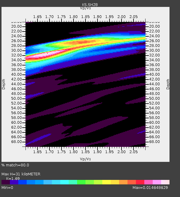
| Thickness Estimate: | 31 km |
| Thickness StdDev: | 2.1 km |
| Vp/Vs Estimate: | 1.69 |
| Vp/Vs StdDev: | 0.07 |
| Vs Estimate: | 3.658 km/s |
| Poisson's Ratio: | 0.23 |
| Peak Value: | 0.01 |
| Assumed Vp: | 6.183 km/s |
| Ps Weight: | 0.33333334 |
| PpPs Weight: | 0.33333334 |
| PsPs Weight: | 0.33333328 |
| Residual Complexity: | 0.688 |
| Nearby stations H: | 31 km +- 0.0 km |
| (2.0 deg) Vp/Vs: | 1.70 +- 0.01 |
12 with match > 90% ( 10.0 %) and 31 with match > 80% ( 25.833334 %) out of 120.
Download stack as xyz text file.
Azimuth Distribution of Events:

Prior Results for this Station
| Study | Thickness | Vp/Vs | Vp | Vs | Poissons Ratio | Extra |
| EARS | 31 km | 1.69 | 6.183 km/s | 3.658 km/s | 0.23 | |
| Crust2.0 | 23 km | 1.81 | 6.183 km/s | 3.422 km/s | 0.28 | S1,continental slope, margin, transition 1 km seds. |
| Global Maxima | 31 km | 1.69 | 6.183 km/s | 3.658 km/s | 0.23 | amp=0.014648629 |
| Local Maxima 1 | 26 km | 1.87 | 6.183 km/s | 3.315 km/s | 0.30 | amp=0.010139806 |
| Local Maxima 2 | 34 km | 1.61 | 6.183 km/s | 3.846 km/s | 0.18 | amp=0.007712119 |
| Local Maxima 3 | 27 km | 1.91 | 6.183 km/s | 3.241 km/s | 0.31 | amp=0.0075444374 |
| Local Maxima 4 | 24 km | 2.10 | 6.183 km/s | 2.948 km/s | 0.35 | amp=0.004802958 |
| Predicted Arrivals for vertical incidence (zero ray parameter) | |
| Ps | 3.46 SECOND |
| PpPs | 13.49 SECOND |
| PsPs/PpSs | 16.95 SECOND |
Events Processed for this Station
Download zip of receiver functions as SAC
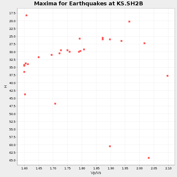
Plot maxima for each earthquake.
Events Used in the Stack
(31 events)| Radial Match | Distance | Baz | FERegion | Time | Lat/Lon | Depth | Magnitude |
| 97.16745 | 44.5 deg | 177.857 deg | Banda Sea | 2023/11/08 04:52:52 UTC | (-6.5, 129.8) | 10 km | 6.9 Mi |
| 95.34188 | 44.2 deg | 177.631 deg | Banda Sea | 2023/11/08 13:02:06 UTC | (-6.1, 129.9) | 10 km | 6.7 mww |
| 93.46163 | 37.8 deg | 290.61 deg | Kyrgyzstan-Xinjiang Border Reg. | 2024/01/22 18:09:04 UTC | (41.3, 78.6) | 13 km | 7.0 Mww |
| 93.39071 | 78.3 deg | 126.157 deg | Tonga Islands | 2024/05/26 20:47:09 UTC | (-19.4, -174.9) | 112 km | 6.6 mww |
| 93.21535 | 49.4 deg | 46.582 deg | Alaska Peninsula | 2023/07/16 06:48:21 UTC | (54.5, -160.8) | 21 km | 7.3 Mi |
| 93.048515 | 38.9 deg | 193.593 deg | Minahassa Peninsula, Sulawesi | 2023/09/09 14:43:24 UTC | (0.0, 119.8) | 9.9 km | 6.0 mww |
| 92.788216 | 64.7 deg | 136.935 deg | Vanuatu Islands | 2023/11/22 04:47:31 UTC | (-15.0, 168.0) | 13 km | 6.7 mww |
| 92.6806 | 44.4 deg | 158.685 deg | New Guinea, Papua New Guinea | 2024/03/23 20:22:07 UTC | (-4.1, 143.0) | 64 km | 7.0 Mi |
| 91.275955 | 64.5 deg | 136.84 deg | Vanuatu Islands | 2023/07/26 12:44:35 UTC | (-14.8, 167.9) | 13 km | 6.4 mww |
| 91.216354 | 77.3 deg | 125.021 deg | Tonga Islands | 2023/07/02 10:27:45 UTC | (-17.9, -174.7) | 247 km | 6.7 Mi |
| 90.4343 | 70.1 deg | 139.247 deg | Vanuatu Islands | 2023/12/07 12:56:30 UTC | (-20.7, 169.2) | 48 km | 7.1 Mww |
| 90.1563 | 52.4 deg | 287.633 deg | Northwestern Afghanistan | 2023/10/15 03:36:00 UTC | (34.6, 62.1) | 8.2 km | 6.3 Mww |
| 89.710335 | 37.0 deg | 181.285 deg | Halmahera, Indonesia | 2023/09/11 12:51:34 UTC | (1.1, 127.5) | 163 km | 6.0 mww |
| 89.22602 | 85.8 deg | 137.935 deg | South Of Kermadec Islands | 2023/09/08 09:09:58 UTC | (-32.7, -179.3) | 90 km | 6.6 mww |
| 88.68578 | 33.8 deg | 183.163 deg | Talaud Islands, Indonesia | 2024/06/12 17:01:20 UTC | (4.4, 126.5) | 34 km | 5.8 Mww |
| 88.59289 | 80.8 deg | 129.7 deg | Tonga Islands Region | 2023/06/16 08:11:34 UTC | (-23.6, -175.9) | 22 km | 6.0 mww |
| 88.30388 | 32.7 deg | 185.965 deg | Mindanao, Philippines | 2023/11/17 08:14:11 UTC | (5.6, 125.0) | 64 km | 6.7 Mww |
| 87.37312 | 84.8 deg | 134.814 deg | Kermadec Islands, New Zealand | 2024/02/09 10:57:48 UTC | (-29.9, -177.3) | 10 km | 6.1 mww |
| 86.70614 | 32.8 deg | 184.029 deg | Mindanao, Philippines | 2023/10/04 11:21:48 UTC | (5.3, 126.1) | 122 km | 6.4 mww |
| 86.676956 | 84.7 deg | 134.987 deg | Kermadec Islands, New Zealand | 2023/10/23 10:10:15 UTC | (-29.9, -177.5) | 23 km | 6.0 Mww |
| 86.28266 | 52.4 deg | 287.582 deg | Northwestern Afghanistan | 2023/10/11 00:41:56 UTC | (34.6, 62.1) | 10 km | 6.3 Mww |
| 86.0712 | 43.8 deg | 51.044 deg | Fox Islands, Aleutian Islands | 2024/05/19 09:35:24 UTC | (52.2, -170.9) | 28 km | 6.0 mww |
| 85.81556 | 56.8 deg | 231.721 deg | South Indian Ocean | 2023/11/14 07:00:56 UTC | (-4.0, 87.1) | 10 km | 6.1 mww |
| 85.35254 | 48.7 deg | 149.076 deg | New Britain Region, P.N.G. | 2024/04/14 20:56:28 UTC | (-5.8, 151.1) | 49 km | 6.5 mww |
| 85.33628 | 40.1 deg | 51.012 deg | Andreanof Islands, Aleutian Is. | 2023/10/16 11:35:31 UTC | (52.4, -176.9) | 187 km | 6.4 Mww |
| 85.11208 | 42.5 deg | 163.569 deg | Irian Jaya, Indonesia | 2023/12/30 17:16:23 UTC | (-3.2, 139.3) | 10 km | 6.5 Mi |
| 85.04076 | 66.5 deg | 138.291 deg | Vanuatu Islands | 2024/05/25 22:23:16 UTC | (-17.1, 167.9) | 29 km | 6.3 mww |
| 84.07712 | 74.3 deg | 127.945 deg | Fiji Islands Region | 2023/10/31 11:10:56 UTC | (-17.5, -179.0) | 548 km | 6.4 mww |
| 83.98615 | 35.4 deg | 181.997 deg | Northern Molucca Sea | 2024/04/09 09:48:01 UTC | (2.7, 127.1) | 35 km | 6.6 mww |
| 83.37287 | 46.7 deg | 155.175 deg | Eastern New Guinea Reg., P.N.G. | 2023/10/07 08:34:26 UTC | (-5.6, 146.1) | 53 km | 6.7 mww |
| 81.44318 | 33.4 deg | 181.361 deg | Talaud Islands, Indonesia | 2023/09/26 01:39:44 UTC | (4.7, 127.5) | 100 km | 5.9 mww |
Losers
(89 events)| Radial Match | Distance | Baz | FERegion | Time | Lat/Lon | Depth | Magnitude | Reason |
| 96.2741 | 79.9 deg | 129.76 deg | South Of Fiji Islands | 2023/06/15 18:06:29 UTC | (-22.9, -176.6) | 206 km | 7.0 Mi | |
| 92.38869 | 44.6 deg | 178.423 deg | Banda Sea | 2023/11/08 04:53:51 UTC | (-6.5, 129.4) | 10 km | 7.0 Mww | |
| 91.834335 | 33.3 deg | 183.501 deg | Talaud Islands, Indonesia | 2024/01/08 20:48:46 UTC | (4.9, 126.3) | 91 km | 7.0 Mi | |
| 79.159065 | 63.4 deg | 136.987 deg | Vanuatu Islands | 2023/08/16 12:47:40 UTC | (-13.9, 167.2) | 193 km | 6.5 Mww | |
| 78.82078 | 57.0 deg | 140.693 deg | Solomon Islands | 2024/04/12 15:59:18 UTC | (-10.2, 160.9) | 42 km | 5.8 Mww | |
| 78.65154 | 50.1 deg | 207.516 deg | Java, Indonesia | 2024/04/27 16:29:51 UTC | (-8.1, 107.3) | 68 km | 6.1 mww | |
| 78.62638 | 36.3 deg | 181.834 deg | Halmahera, Indonesia | 2023/11/22 02:48:51 UTC | (1.8, 127.2) | 102 km | 6.0 Mww | |
| 78.44943 | 48.2 deg | 150.132 deg | New Britain Region, P.N.G. | 2024/05/14 17:15:48 UTC | (-5.6, 150.2) | 121 km | 5.6 mww | |
| 78.38896 | 33.8 deg | 276.091 deg | Xizang | 2024/06/01 00:46:37 UTC | (34.2, 86.4) | 13 km | 5.6 mb | |
| 77.32768 | 77.7 deg | 126.884 deg | Tonga Islands | 2024/05/05 07:13:39 UTC | (-19.4, -175.9) | 10 km | 5.7 mww | |
| 77.24184 | 81.0 deg | 129.735 deg | Tonga Islands Region | 2023/06/18 15:04:49 UTC | (-23.8, -175.7) | 10 km | 5.8 Mww | |
| 77.0996 | 48.9 deg | 146.775 deg | New Britain Region, P.N.G. | 2023/09/28 19:21:17 UTC | (-5.3, 152.8) | 49 km | 5.7 Mww | |
| 76.157486 | 47.4 deg | 146.714 deg | New Ireland Region, P.N.G. | 2024/05/18 14:04:44 UTC | (-3.8, 152.1) | 10 km | 5.7 mww | |
| 76.093636 | 48.2 deg | 186.001 deg | Timor Region | 2023/11/01 21:04:45 UTC | (-10.0, 123.7) | 28 km | 6.0 mww | |
| 75.580696 | 77.8 deg | 126.049 deg | Tonga Islands | 2024/01/18 22:12:20 UTC | (-18.9, -175.1) | 218 km | 6.4 Mww | |
| 74.697495 | 37.8 deg | 290.462 deg | Kyrgyzstan-Xinjiang Border Reg. | 2024/01/29 22:27:41 UTC | (41.2, 78.7) | 10 km | 5.7 mww | |
| 73.59954 | 77.4 deg | 125.763 deg | Tonga Islands | 2023/05/27 00:11:00 UTC | (-18.5, -175.2) | 215 km | 6.0 mww | |
| 73.26244 | 36.3 deg | 186.956 deg | Minahassa Peninsula, Sulawesi | 2023/11/15 23:26:15 UTC | (2.0, 124.1) | 303 km | 5.7 Mww | |
| 72.951385 | 80.6 deg | 128.494 deg | Tonga Islands Region | 2023/07/21 19:01:43 UTC | (-22.6, -175.0) | 11 km | 5.5 Mww | |
| 72.25049 | 30.1 deg | 140.177 deg | South Of Mariana Islands | 2023/08/14 13:51:54 UTC | (13.4, 147.5) | 10 km | 6.1 mww | |
| 72.10944 | 52.4 deg | 287.697 deg | Northwestern Afghanistan | 2023/10/07 06:41:02 UTC | (34.6, 61.9) | 10 km | 6.2 mww | |
| 71.908745 | 46.1 deg | 196.227 deg | Bali Sea | 2023/08/28 19:55:31 UTC | (-6.8, 116.5) | 514 km | 7.1 Mww | |
| 71.477715 | 65.1 deg | 137.523 deg | Vanuatu Islands | 2023/09/28 14:40:26 UTC | (-15.6, 167.7) | 126 km | 6.0 mww | |
| 71.30087 | 50.0 deg | 202.879 deg | South Of Java, Indonesia | 2023/06/07 17:04:55 UTC | (-9.2, 110.7) | 31 km | 5.6 Mww | |
| 70.54559 | 47.7 deg | 153.982 deg | Eastern New Guinea Reg., P.N.G. | 2024/05/21 03:35:58 UTC | (-6.3, 147.3) | 50 km | 5.7 mww | |
| 70.455444 | 37.2 deg | 51.577 deg | Rat Islands, Aleutian Islands | 2024/03/30 16:28:57 UTC | (52.1, 178.4) | 115 km | 5.8 mww | |
| 70.026596 | 74.6 deg | 273.989 deg | Eastern Gulf Of Aden | 2023/06/03 07:17:46 UTC | (12.6, 48.2) | 10 km | 5.9 mww | |
| 69.86564 | 46.2 deg | 228.299 deg | Off W Coast Of Northern Sumatra | 2024/05/28 11:52:39 UTC | (2.8, 95.6) | 18 km | 5.9 mww | |
| 69.858864 | 30.1 deg | 41.778 deg | Komandorskiye Ostrova Region | 2023/10/26 16:05:11 UTC | (56.1, 164.7) | 2.4 km | 5.9 Mww | |
| 69.48227 | 45.4 deg | 159.335 deg | New Guinea, Papua New Guinea | 2023/09/05 15:03:17 UTC | (-5.3, 142.9) | 52 km | 5.8 mww | |
| 69.46476 | 48.7 deg | 145.235 deg | New Ireland Region, P.N.G. | 2023/10/03 01:56:17 UTC | (-4.5, 153.7) | 86 km | 5.7 mww | |
| 69.44565 | 36.0 deg | 145.288 deg | E. Caroline Islands, Micronesia | 2023/09/03 21:29:58 UTC | (6.8, 148.0) | 10 km | 5.5 mww | |
| 69.40447 | 48.6 deg | 149.665 deg | New Britain Region, P.N.G. | 2024/03/13 15:13:23 UTC | (-5.9, 150.6) | 50 km | 6.0 mww | |
| 69.40123 | 45.2 deg | 286.402 deg | Hindu Kush Region, Afghanistan | 2024/01/11 09:20:26 UTC | (36.5, 70.6) | 207 km | 6.4 Mww | |
| 69.32345 | 50.2 deg | 209.922 deg | Java, Indonesia | 2023/08/17 04:28:48 UTC | (-7.4, 105.5) | 58 km | 5.3 Mww | |
| 68.597916 | 46.6 deg | 155.069 deg | Eastern New Guinea Reg., P.N.G. | 2023/10/07 08:40:13 UTC | (-5.5, 146.2) | 74 km | 6.7 Mww | |
| 68.34234 | 49.7 deg | 145.297 deg | Solomon Islands | 2024/06/09 16:28:38 UTC | (-5.4, 154.1) | 125 km | 5.7 Mww | |
| 68.31329 | 50.3 deg | 146.806 deg | New Britain Region, P.N.G. | 2023/12/08 15:27:26 UTC | (-6.5, 153.3) | 10 km | 5.5 Mww | |
| 67.91539 | 41.1 deg | 52.656 deg | Andreanof Islands, Aleutian Is. | 2023/12/21 14:55:58 UTC | (51.3, -175.4) | 30 km | 6.1 Mww | |
| 67.8516 | 87.6 deg | 181.508 deg | Western Indian-Antarctic Ridge | 2024/03/13 20:06:33 UTC | (-49.7, 125.9) | 10 km | 5.5 Mww | |
| 67.595955 | 79.1 deg | 309.045 deg | Southern Greece | 2024/03/29 07:12:47 UTC | (37.3, 21.3) | 25 km | 5.8 Mww | |
| 67.41021 | 37.5 deg | 277.308 deg | Xizang | 2024/04/13 05:44:39 UTC | (33.5, 81.9) | 10 km | 5.5 mb | |
| 67.27626 | 84.7 deg | 137.071 deg | Kermadec Islands Region | 2024/04/25 05:07:36 UTC | (-31.3, -179.3) | 179 km | 5.5 mww | |
| 66.79861 | 52.7 deg | 233.114 deg | South Indian Ocean | 2023/07/01 07:29:40 UTC | (-0.1, 88.7) | 10 km | 5.8 mww | |
| 66.70941 | 48.9 deg | 217.798 deg | Southern Sumatra, Indonesia | 2024/06/05 02:20:26 UTC | (-3.6, 100.7) | 10 km | 5.6 mww | |
| 66.566124 | 66.9 deg | 254.914 deg | Carlsberg Ridge | 2024/01/06 11:46:32 UTC | (3.1, 65.5) | 10 km | 5.6 Mww | |
| 65.529335 | 80.9 deg | 129.479 deg | Tonga Islands Region | 2023/07/02 02:41:17 UTC | (-23.5, -175.6) | 10 km | 5.6 Mww | |
| 65.19586 | 69.8 deg | 139.148 deg | Vanuatu Islands | 2023/12/24 02:00:31 UTC | (-20.4, 169.1) | 10 km | 5.8 mb | |
| 64.84136 | 83.5 deg | 135.156 deg | Kermadec Islands, New Zealand | 2024/05/17 20:58:27 UTC | (-29.1, -178.5) | 196 km | 5.8 Mww | |
| 64.80009 | 30.7 deg | 183.791 deg | Mindanao, Philippines | 2023/10/19 18:58:52 UTC | (7.4, 126.3) | 11 km | 5.9 Mww | |
| 64.7845 | 46.3 deg | 202.121 deg | Java Sea | 2024/03/22 08:52:58 UTC | (-5.9, 112.4) | 8.5 km | 6.4 Mww | |
| 64.01492 | 45.1 deg | 286.288 deg | Hindu Kush Region, Afghanistan | 2023/08/05 16:01:49 UTC | (36.5, 70.7) | 207 km | 5.8 Mww | |
| 63.95663 | 47.8 deg | 152.783 deg | New Britain Region, P.N.G. | 2023/11/14 12:52:25 UTC | (-6.1, 148.2) | 58 km | 5.9 mww | |
| 63.937744 | 44.6 deg | 50.946 deg | Fox Islands, Aleutian Islands | 2024/05/02 06:58:01 UTC | (52.1, -169.5) | 16 km | 5.5 mww | |
| 63.505512 | 41.6 deg | 237.579 deg | Andaman Islands, India Region | 2023/07/28 19:23:48 UTC | (10.5, 93.5) | 102 km | 5.9 mww | |
| 62.85294 | 49.2 deg | 229.452 deg | Off W Coast Of Northern Sumatra | 2023/09/27 17:47:21 UTC | (0.9, 93.1) | 10 km | 5.5 Mww | |
| 62.667603 | 76.1 deg | 136.228 deg | South Of Fiji Islands | 2023/09/05 00:55:24 UTC | (-23.9, 175.5) | 12 km | 5.7 Mww | |
| 62.421947 | 48.7 deg | 149.139 deg | New Britain Region, P.N.G. | 2024/05/01 23:45:25 UTC | (-5.8, 151.0) | 29 km | 5.9 Mww | |
| 61.832222 | 72.1 deg | 139.357 deg | Southeast Of Loyalty Islands | 2023/06/08 09:19:28 UTC | (-22.4, 170.3) | 18 km | 5.7 mww | |
| 61.669884 | 47.3 deg | 185.857 deg | Timor Region | 2023/07/25 00:25:10 UTC | (-9.1, 123.9) | 89 km | 5.5 mww | |
| 61.443344 | 63.5 deg | 137.034 deg | Vanuatu Islands | 2023/09/21 21:11:49 UTC | (-14.0, 167.2) | 188 km | 6.1 mww | |
| 61.237614 | 39.2 deg | 270.27 deg | Nepal | 2023/11/03 18:02:54 UTC | (28.9, 82.2) | 18 km | 5.6 Mww | |
| 59.999527 | 71.9 deg | 245.116 deg | Mid-Indian Ridge | 2023/12/29 01:18:49 UTC | (-7.1, 67.9) | 7.7 km | 5.8 Mww | |
| 59.14557 | 62.7 deg | 136.607 deg | Vanuatu Islands | 2023/10/28 09:55:28 UTC | (-13.1, 167.1) | 201 km | 5.6 mww | |
| 59.08448 | 39.6 deg | 182.77 deg | Southern Molucca Sea | 2023/07/17 04:42:14 UTC | (-1.5, 126.5) | 10 km | 5.6 mww | |
| 59.070263 | 37.9 deg | 51.845 deg | Rat Islands, Aleutian Islands | 2024/02/28 15:50:21 UTC | (51.9, 179.6) | 119 km | 5.5 mww | |
| 58.96415 | 54.1 deg | 354.7 deg | North Of Svalbard | 2024/05/19 02:31:21 UTC | (85.2, 12.1) | 10 km | 5.4 mww | |
| 58.097458 | 77.0 deg | 129.512 deg | Fiji Islands Region | 2024/03/02 00:26:40 UTC | (-20.6, -178.4) | 537 km | 5.8 mww | |
| 57.52432 | 68.2 deg | 304.262 deg | Turkey | 2024/04/18 15:11:25 UTC | (40.0, 36.0) | 10 km | 5.6 Mww | |
| 57.493626 | 77.4 deg | 126.118 deg | Tonga Islands | 2023/12/11 06:33:31 UTC | (-18.7, -175.5) | 238 km | 6.1 Mww | |
| 57.430386 | 57.2 deg | 140.411 deg | Solomon Islands | 2023/05/28 03:29:55 UTC | (-10.1, 161.2) | 104 km | 5.6 mww | |
| 56.96386 | 38.4 deg | 185.258 deg | Southern Molucca Sea | 2023/08/04 11:48:37 UTC | (-0.2, 125.0) | 25 km | 5.6 mww | |
| 56.859894 | 79.3 deg | 41.131 deg | Western Idaho | 2024/02/26 17:25:43 UTC | (44.4, -116.1) | 8.9 km | 5.5 Ml | |
| 56.843754 | 42.3 deg | 152.924 deg | Admiralty Islands Region, P.N.G. | 2024/02/21 12:11:31 UTC | (-0.9, 146.1) | 10 km | 5.5 Mww | |
| 55.000797 | 78.1 deg | 133.134 deg | South Of Fiji Islands | 2023/10/22 19:31:43 UTC | (-23.7, 179.4) | 537 km | 5.5 Mww | |
| 54.546303 | 84.2 deg | 137.707 deg | Kermadec Islands Region | 2023/10/14 06:34:11 UTC | (-31.3, 179.7) | 415 km | 5.7 mww | |
| 54.36186 | 62.0 deg | 135.762 deg | Santa Cruz Islands | 2024/05/21 09:50:43 UTC | (-12.1, 167.3) | 248 km | 5.4 Mww | |
| 53.586163 | 38.3 deg | 184.907 deg | Southern Molucca Sea | 2024/03/13 18:56:13 UTC | (-0.1, 125.2) | 26 km | 5.8 mww | |
| 52.133247 | 42.3 deg | 163.572 deg | Near North Coast Of Irian Jaya | 2024/06/07 16:31:03 UTC | (-3.0, 139.2) | 25 km | 5.6 mb | |
| 51.282227 | 49.7 deg | 203.903 deg | Java, Indonesia | 2023/06/30 12:57:42 UTC | (-8.7, 110.0) | 86 km | 5.8 mww | |
| 51.26745 | 36.3 deg | 239.643 deg | Near South Coast Of Myanmar | 2023/06/19 01:40:23 UTC | (15.3, 96.3) | 5.3 km | 5.4 Mww | |
| 50.646313 | 75.3 deg | 274.158 deg | Eastern Gulf Of Aden | 2023/12/05 07:31:33 UTC | (12.3, 47.4) | 10 km | 5.6 mww | |
| 48.70197 | 32.3 deg | 182.554 deg | Mindanao, Philippines | 2024/03/08 09:11:46 UTC | (5.8, 126.9) | 125 km | 6.0 mww | |
| 48.458305 | 46.7 deg | 155.499 deg | Eastern New Guinea Reg., P.N.G. | 2023/10/07 13:10:40 UTC | (-5.7, 145.9) | 38 km | 5.7 mww | |
| 48.151802 | 70.0 deg | 138.854 deg | Vanuatu Islands | 2023/12/08 07:19:56 UTC | (-20.4, 169.5) | 46 km | 5.6 mww | |
| 45.541077 | 34.8 deg | 290.895 deg | Northern Xinjiang, China | 2024/04/10 14:56:17 UTC | (42.0, 82.6) | 6.5 km | 5.4 Mww | |
| 42.091167 | 51.3 deg | 153.877 deg | Eastern New Guinea Reg., P.N.G. | 2023/11/21 07:10:15 UTC | (-9.6, 148.6) | 10 km | 5.5 mww | |
| 40.03812 | 37.9 deg | 290.506 deg | Kyrgyzstan-Xinjiang Border Reg. | 2024/01/22 19:36:47 UTC | (41.2, 78.6) | 10 km | 5.5 mb | |
| 39.974213 | 30.1 deg | 183.211 deg | Mindanao, Philippines | 2023/12/02 14:44:36 UTC | (8.1, 126.6) | 35 km | 5.5 mb |

