
Station LB LDS - Leeds, Washington County, Utah, USA
Network: LB - Leo Brady Network
Nearby stations (2 deg radius)
| Station | Name | (Lat, Lon) | Start / End | Elevation |
| LDS | Leeds, Washington County, Utah, USA | (37.24, -113.35) | 1996-12-23 / 1998-06-17 | 1101 m |
| Crust2 Type: | MD,thin extended crust, 1.5 km seds. |
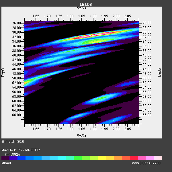
| Thickness Estimate: | 31 km |
| Thickness StdDev: | 7.9 km |
| Vp/Vs Estimate: | 1.89 |
| Vp/Vs StdDev: | 0.11 |
| Vs Estimate: | 3.273 km/s |
| Poisson's Ratio: | 0.31 |
| Peak Value: | 0.06 |
| Assumed Vp: | 6.194 km/s |
| Ps Weight: | 0.33333334 |
| PpPs Weight: | 0.33333334 |
| PsPs Weight: | 0.33333328 |
| Residual Complexity: | 0.685 |
| Nearby stations H: | +- |
| (2.0 deg) Vp/Vs: | +- |
2 with match > 90% ( 25.0 %) and 4 with match > 80% ( 50.0 %) out of 8.
Download stack as xyz text file.
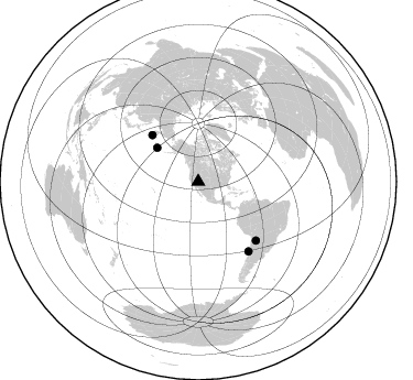
Azimuth Distribution of Events:
Prior Results for this Station
| Study | Thickness | Vp/Vs | Vp | Vs | Poissons Ratio | Extra |
| EARS | 31 km | 1.89 | 6.194 km/s | 3.273 km/s | 0.31 | |
| Crust2.0 | 34 km | 1.78 | 6.194 km/s | 3.483 km/s | 0.27 | MD,thin extended crust, 1.5 km seds. |
| Global Maxima | 31 km | 1.89 | 6.194 km/s | 3.273 km/s | 0.31 | amp=0.057402298 |
| Local Maxima 1 | 52 km | 1.60 | 6.194 km/s | 3.865 km/s | 0.18 | amp=0.046198975 |
| Local Maxima 2 | 33 km | 1.98 | 6.194 km/s | 3.136 km/s | 0.33 | amp=0.031319913 |
| Local Maxima 3 | 58 km | 1.94 | 6.194 km/s | 3.197 km/s | 0.32 | amp=0.02950035 |
| Local Maxima 4 | 38 km | 1.79 | 6.194 km/s | 3.456 km/s | 0.27 | amp=0.025377007 |
| Predicted Arrivals for vertical incidence (zero ray parameter) | |
| Ps | 4.50 SECOND |
| PpPs | 14.59 SECOND |
| PsPs/PpSs | 19.10 SECOND |
Events Processed for this Station
Download zip of receiver functions as SAC
Plot maxima for each earthquake.
Events Used in the Stack
(4 events)| Radial Match | Distance | Baz | FERegion | Time | Lat/Lon | Depth | Magnitude |
| 94.850075 | 77.8 deg | 144.203 deg | Near Coast Of Central Chile | 1997/07/27 05:21:29 GMT | (-30.5, -71.9) | 33 km | 5.6 MB, 5.8 MS, 6.3 UNKNOWN, 6.2 MW |
| 90.91142 | 59.5 deg | 315.386 deg | Off East Coast Of Kamchatka | 1998/06/01 05:34:03 GMT | (52.9, 160.1) | 44 km | 6.2 MB, 6.3 MS, 6.5 UNKNOWN, 6.4 MW |
| 89.00625 | 74.5 deg | 135.574 deg | Jujuy Province, Argentina | 1997/07/20 10:14:22 GMT | (-23.0, -66.3) | 256 km | 5.7 MB, 6.1 UNKNOWN, 5.7 ME |
| 84.16932 | 48.4 deg | 309.308 deg | Rat Islands, Aleutian Islands | 1997/03/26 02:08:57 GMT | (51.3, 179.5) | 33 km | 6.0 MB, 6.5 MS, 6.7 UNKNOWN, 6.3 ML |
Losers
(4 events)| Radial Match | Distance | Baz | FERegion | Time | Lat/Lon | Depth | Magnitude | Reason |
| 87.25926 | 77.4 deg | 143.957 deg | Near Coast Of Central Chile | 1997/07/06 09:54:00 GMT | (-30.1, -71.9) | 19 km | 5.8 MB, 6.5 MS, 6.8 UNKNOWN, 6.4 ME | |
| 65.44488 | 86.3 deg | 298.358 deg | Volcano Islands, Japan Region | 1998/02/07 01:18:59 GMT | (24.8, 141.7) | 525 km | 5.9 MB, 6.4 UNKNOWN | |
| 62.854576 | 58.3 deg | 316.116 deg | Off East Coast Of Kamchatka | 1997/12/05 11:35:19 GMT | (53.9, 161.6) | 33 km | 5.7 MB | |
| 59.921715 | 70.8 deg | 310.873 deg | Kuril Islands | 1997/02/28 11:32:18 GMT | (43.9, 147.9) | 33 km | 6.1 MB, 5.5 MS, 5.9 UNKNOWN, 5.7 MW |
