
Station LD BNY - Binghamton University
Network: LD - Lamont-Doherty Cooperative Seismographic Network
Nearby stations (2 deg radius)
| Station | Name | (Lat, Lon) | Start / End | Elevation |
| BNY | Binghamton University | (42.09, -75.97) | 2015-10-13 / 2599-12-31 | 292 m |
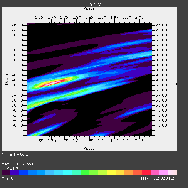
| Crust2 Type: | Q2,orogen/39km no ice, Appalachians, North Andes, 0.5 km seds. |
| Thickness Estimate: | 49 km |
| Thickness StdDev: | 4.8 km |
| Vp/Vs Estimate: | 1.70 |
| Vp/Vs StdDev: | 0.08 |
| Vs Estimate: | 3.776 km/s |
| Poisson's Ratio: | 0.24 |
| Peak Value: | 0.19 |
| Assumed Vp: | 6.419 km/s |
| Ps Weight: | 0.33333334 |
| PpPs Weight: | 0.33333334 |
| PsPs Weight: | 0.33333328 |
| Residual Complexity: | 0.683 |
| Nearby stations H: | +- |
| (2.0 deg) Vp/Vs: | +- |
4 with match > 90% ( 33.333332 %) and 8 with match > 80% ( 66.666664 %) out of 12.
Download stack as xyz text file.
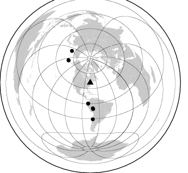
Azimuth Distribution of Events:
Prior Results for this Station
| Study | Thickness | Vp/Vs | Vp | Vs | Poissons Ratio | Extra |
| EARS | 49 km | 1.70 | 6.419 km/s | 3.776 km/s | 0.24 | |
| Crust2.0 | 39 km | 1.75 | 6.419 km/s | 3.659 km/s | 0.26 | Q2,orogen/39km no ice, Appalachians, North Andes, 0.5 km seds. |
| Global Maxima | 49 km | 1.70 | 6.419 km/s | 3.776 km/s | 0.24 | amp=0.19028115 |
| Local Maxima 1 | 56 km | 1.68 | 6.419 km/s | 3.827 km/s | 0.22 | amp=0.10368376 |
| Local Maxima 2 | 70 km | 1.63 | 6.419 km/s | 3.938 km/s | 0.20 | amp=0.100264326 |
| Local Maxima 3 | 52 km | 1.81 | 6.419 km/s | 3.547 km/s | 0.28 | amp=0.089196935 |
| Local Maxima 4 | 38 km | 2.10 | 6.419 km/s | 3.06 km/s | 0.35 | amp=0.08607515 |
| Predicted Arrivals for vertical incidence (zero ray parameter) | |
| Ps | 5.34 SECOND |
| PpPs | 20.61 SECOND |
| PsPs/PpSs | 25.95 SECOND |
Events Processed for this Station
Download zip of receiver functions as SAC
Plot maxima for each earthquake.
Events Used in the Stack
(8 events)| Radial Match | Distance | Baz | FERegion | Time | Lat/Lon | Depth | Magnitude |
| 97.35928 | 41.7 deg | 185.974 deg | Near Coast Of Ecuador | 2016/04/16 23:58:37 GMT | (0.4, -79.9) | 19 km | 7.8 MWW, 7.4 MI |
| 93.09933 | 73.5 deg | 329.933 deg | Kamchatka Peninsula, Russia | 2016/01/30 03:25:10 GMT | (54.0, 158.5) | 161 km | 7.2 MWW, 7.0 MI, 7.2 MWB |
| 92.75145 | 52.6 deg | 173.802 deg | Peru-Brazil Border Region | 2015/11/24 22:45:38 GMT | (-10.6, -71.0) | 602 km | 7.5 MWW, 6.9 MI |
| 92.09878 | 41.6 deg | 185.718 deg | Near Coast Of Ecuador | 2016/05/18 07:57:05 GMT | (0.4, -79.8) | 32 km | 6.7 MWP, 6.7 MWW, 6.7 MI |
| 89.21558 | 63.0 deg | 316.031 deg | Andreanof Islands, Aleutian Is. | 2016/03/19 01:35:12 GMT | (51.5, -174.2) | 17 km | 6.0 MWW, 5.5 ML, 5.8 MWB |
| 88.3665 | 72.7 deg | 176.017 deg | Near Coast Of Central Chile | 2015/11/07 07:31:42 GMT | (-30.9, -71.5) | 36 km | 6.8 MWP, 6.8 MI |
| 83.34876 | 62.2 deg | 315.783 deg | Andreanof Islands, Aleutian Is. | 2015/11/09 16:03:45 GMT | (51.7, -173.1) | 10 km | 6.2 MWB, 6.3 MI |
| 80.37432 | 51.2 deg | 174.046 deg | Peru-Brazil Border Region | 2015/11/26 05:45:18 GMT | (-9.2, -71.3) | 604 km | 6.4 MWP |
Losers
(4 events)| Radial Match | Distance | Baz | FERegion | Time | Lat/Lon | Depth | Magnitude | Reason |
| 94.12972 | 96.1 deg | 26.449 deg | Hindu Kush Region, Afghanistan | 2015/10/26 09:09:32 GMT | (36.4, 70.7) | 212 km | 7.5 MWW, 7.5 MWB | |
| 64.10437 | 62.7 deg | 166.548 deg | Southern Bolivia | 2016/01/14 03:25:28 GMT | (-19.8, -63.3) | 582 km | 6.1 MWW, 6.1 MWB | |
| 52.286777 | 89.3 deg | 332.204 deg | Hokkaido, Japan Region | 2016/01/14 03:25:34 GMT | (42.0, 142.7) | 51 km | 6.7 MWP, 6.7 MI | |
| 44.48776 | 52.1 deg | 173.889 deg | Peru-Brazil Border Region | 2015/11/24 22:50:53 GMT | (-10.1, -71.1) | 595 km | 5.9 MB |

