
Station LD CUNY - Queens College, CUNY, Queens, NY
Network: LD - Lamont-Doherty Cooperative Seismographic Network
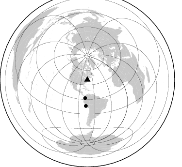
Nearby stations (2 deg radius)
| Station | Name | (Lat, Lon) | Start / End | Elevation |
| CUNY | Queens College, CUNY, Queens, NY | (40.73, -73.82) | 2002-06-02 / 2499-01-01 | 0.0 km |
| Crust2 Type: | T6,Margin /shield transition, 1 km seds. |
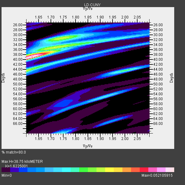
| Thickness Estimate: | 39 km |
| Thickness StdDev: | 1.7 km |
| Vp/Vs Estimate: | 1.62 |
| Vp/Vs StdDev: | 0.04 |
| Vs Estimate: | 3.989 km/s |
| Poisson's Ratio: | 0.19 |
| Peak Value: | 0.05 |
| Assumed Vp: | 6.472 km/s |
| Ps Weight: | 0.33333334 |
| PpPs Weight: | 0.33333334 |
| PsPs Weight: | 0.33333328 |
| Residual Complexity: | 0.776 |
| Nearby stations H: | +- |
| (2.0 deg) Vp/Vs: | +- |
2 with match > 90% ( 25.0 %) and 2 with match > 80% ( 25.0 %) out of 8.
Download stack as xyz text file.
Azimuth Distribution of Events:
Prior Results for this Station
| Study | Thickness | Vp/Vs | Vp | Vs | Poissons Ratio | Extra |
| EARS | 39 km | 1.62 | 6.472 km/s | 3.989 km/s | 0.19 | |
| Crust2.0 | 32 km | 1.79 | 6.472 km/s | 3.622 km/s | 0.27 | T6,Margin /shield transition, 1 km seds. |
| Global Maxima | 39 km | 1.62 | 6.472 km/s | 3.989 km/s | 0.19 | amp=0.052105915 |
| Local Maxima 1 | 44 km | 1.60 | 6.472 km/s | 4.039 km/s | 0.18 | amp=0.029725023 |
| Local Maxima 2 | 31 km | 1.74 | 6.472 km/s | 3.719 km/s | 0.25 | amp=0.029492252 |
| Local Maxima 3 | 44 km | 2.00 | 6.472 km/s | 3.232 km/s | 0.33 | amp=0.02508597 |
| Local Maxima 4 | 34 km | 1.77 | 6.472 km/s | 3.656 km/s | 0.27 | amp=0.024316255 |
| Predicted Arrivals for vertical incidence (zero ray parameter) | |
| Ps | 3.73 SECOND |
| PpPs | 15.70 SECOND |
| PsPs/PpSs | 19.43 SECOND |
Events Processed for this Station
Download zip of receiver functions as SAC
Plot maxima for each earthquake.
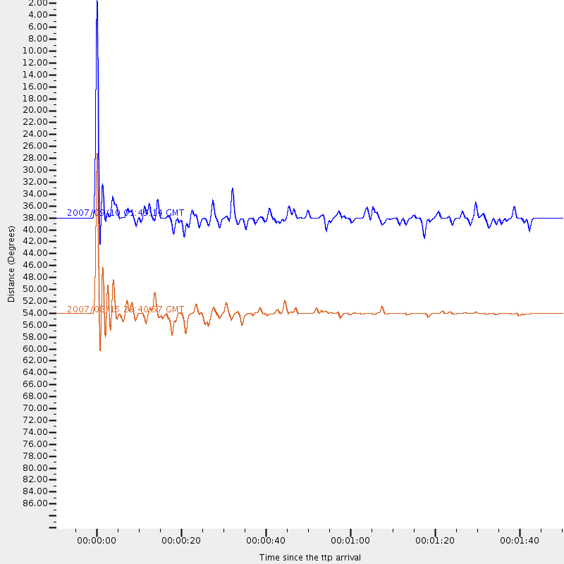
Events Used in the Stack
(2 events)| Radial Match | Distance | Baz | FERegion | Time | Lat/Lon | Depth | Magnitude |
| 95.34293 | 53.9 deg | 183.355 deg | Near Coast Of Peru | 2007/08/15 23:40:57 GMT | (-13.4, -76.6) | 39 km | 6.7 MB, 7.9 MS, 8.0 MW, 7.5 ME |
| 94.42796 | 37.8 deg | 186.775 deg | Near West Coast Of Colombia | 2007/09/10 01:49:14 GMT | (3.0, -78.0) | 31 km | 6.1 MB, 6.7 MS, 6.8 MW |
Losers
(6 events)| Radial Match | Distance | Baz | FERegion | Time | Lat/Lon | Depth | Magnitude | Reason |
| 78.23152 | 76.8 deg | 333.295 deg | Sea Of Okhotsk | 2008/11/24 09:02:58 GMT | (54.2, 154.3) | 492 km | 6.5 MB, 7.3 MW, 7.3 MW | |
| 41.08978 | 67.2 deg | 318.786 deg | Andreanof Islands, Aleutian Is. | 2009/06/22 21:05:33 GMT | (51.3, -178.2) | 29 km | 5.5 MB, 5.0 MS, 5.4 MW, 5.4 MW | |
| 37.477238 | 74.9 deg | 178.448 deg | Near Coast Of Central Chile | 2010/03/11 15:06:02 GMT | (-34.5, -72.0) | 32 km | 6.0 MB, 5.9 ML | |
| 36.8061 | 87.6 deg | 331.518 deg | Kuril Islands | 2010/03/06 13:31:12 GMT | (44.2, 147.6) | 53 km | 5.7 MW, 5.1 MS, 5.4 MB, 5.6 MW | |
| 29.39089 | 31.4 deg | 85.266 deg | Azores Islands Region | 2009/11/04 18:41:44 GMT | (36.2, -33.9) | 10 km | 5.7 MB, 5.6 MS, 5.9 MW, 5.8 MW | |
| 16.115696 | 42.7 deg | 212.354 deg | Galapagos Islands Region | 2009/03/15 03:14:31 GMT | (2.4, -95.1) | 10 km | 5.5 MS, 5.4 MB, 5.8 MW, 5.8 MW |
