
Station LD GENY - SUNY Geneso, New York
Network: LD - Lamont-Doherty Cooperative Seismographic Network
Nearby stations (2 deg radius)
| Station | Name | (Lat, Lon) | Start / End | Elevation |
| GENY | SUNY Geneso, New York | (42.77, -77.82) | 2001-10-27 / 2499-01-01 | 0.0 m |
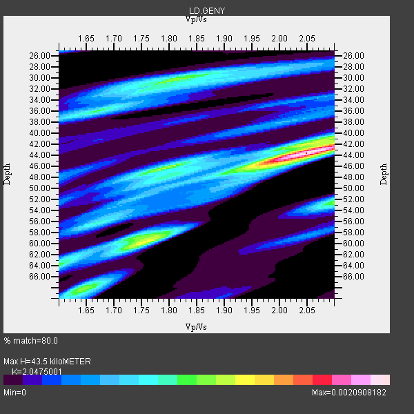
| Crust2 Type: | Q6,orogen/41.5km no ice, cordilleras, 1.5 km seds. |
| Thickness Estimate: | 44 km |
| Thickness StdDev: | 6.6 km |
| Vp/Vs Estimate: | 2.05 |
| Vp/Vs StdDev: | 0.13 |
| Vs Estimate: | 3.163 km/s |
| Poisson's Ratio: | 0.34 |
| Peak Value: | 0.00 |
| Assumed Vp: | 6.476 km/s |
| Ps Weight: | 0.33333334 |
| PpPs Weight: | 0.33333334 |
| PsPs Weight: | 0.33333328 |
| Residual Complexity: | 0.782 |
| Nearby stations H: | +- |
| (2.0 deg) Vp/Vs: | +- |
10 with match > 90% ( 76.92308 %) and 13 with match > 80% ( 100.0 %) out of 13.
Download stack as xyz text file.
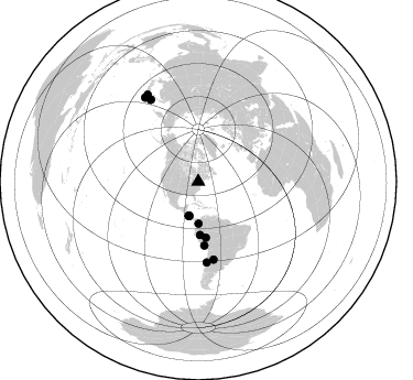
Azimuth Distribution of Events:
Prior Results for this Station
| Study | Thickness | Vp/Vs | Vp | Vs | Poissons Ratio | Extra |
| EARS | 44 km | 2.05 | 6.476 km/s | 3.163 km/s | 0.34 | |
| Crust2.0 | 42 km | 1.76 | 6.476 km/s | 3.675 km/s | 0.26 | Q6,orogen/41.5km no ice, cordilleras, 1.5 km seds. |
| Global Maxima | 44 km | 2.05 | 6.476 km/s | 3.163 km/s | 0.34 | amp=0.0020908182 |
| Local Maxima 1 | 60 km | 1.75 | 6.476 km/s | 3.701 km/s | 0.26 | amp=0.0012470828 |
| Local Maxima 2 | 46 km | 1.80 | 6.476 km/s | 3.598 km/s | 0.28 | amp=0.001131582 |
| Local Maxima 3 | 30 km | 1.80 | 6.476 km/s | 3.603 km/s | 0.28 | amp=0.0011112136 |
| Local Maxima 4 | 68 km | 1.64 | 6.476 km/s | 3.955 km/s | 0.20 | amp=9.696376E-4 |
| Predicted Arrivals for vertical incidence (zero ray parameter) | |
| Ps | 7.04 SECOND |
| PpPs | 20.47 SECOND |
| PsPs/PpSs | 27.51 SECOND |
Events Processed for this Station
Download zip of receiver functions as SAC
Plot maxima for each earthquake.
Events Used in the Stack
(13 events)| Radial Match | Distance | Baz | FERegion | Time | Lat/Lon | Depth | Magnitude |
| 98.50301 | 48.2 deg | 178.107 deg | Northern Peru | 2005/09/26 01:55:37 GMT | (-5.7, -76.4) | 115 km | 6.7 MB, 7.5 MW, 7.5 MW |
| 97.29046 | 73.5 deg | 173.996 deg | Near Coast Of Central Chile | 2002/06/18 13:56:22 GMT | (-30.8, -71.1) | 54 km | 6.0 MB, 6.6 MW, 6.4 MW |
| 96.489204 | 90.6 deg | 327.646 deg | Off East Coast Of Honshu, Japan | 2005/11/14 21:38:51 GMT | (38.1, 144.9) | 11 km | 6.7 MB, 6.8 MS, 7.0 MW, 6.9 MW |
| 95.59638 | 37.9 deg | 179.499 deg | Near West Coast Of Colombia | 2004/11/15 09:06:56 GMT | (4.7, -77.5) | 15 km | 6.6 MB, 7.1 MS, 7.2 MW, 7.1 MW |
| 93.559616 | 91.6 deg | 329.696 deg | Near East Coast Of Honshu, Japan | 2005/08/16 02:46:28 GMT | (38.3, 142.0) | 36 km | 6.5 MB, 6.8 MS, 7.2 MW, 7.1 MW |
| 93.52263 | 51.1 deg | 172.262 deg | Western Brazil | 2002/10/12 20:09:11 GMT | (-8.3, -71.7) | 534 km | 6.5 MB, 6.9 MW, 6.9 MW |
| 93.45862 | 32.1 deg | 194.36 deg | Nicaragua | 2005/08/03 11:03:15 GMT | (11.2, -85.5) | 14 km | 6.0 MB, 6.5 MS, 6.3 MW, 6.3 MW |
| 92.84247 | 86.3 deg | 329.952 deg | Hokkaido, Japan Region | 2004/11/28 18:32:14 GMT | (43.0, 145.1) | 39 km | 6.4 MB, 6.7 MS, 7.0 MW, 7.0 MW |
| 92.06055 | 71.8 deg | 168.925 deg | Santiago Del Estero Prov., Arg. | 2004/09/07 11:53:06 GMT | (-28.6, -65.8) | 22 km | 6.1 MB, 6.1 MS, 6.4 MW, 6.2 MW |
| 91.996956 | 32.2 deg | 195.5 deg | Near Coast Of Nicaragua | 2005/07/02 02:16:43 GMT | (11.2, -86.2) | 27 km | 5.6 MB, 6.4 MS, 6.6 MW, 6.6 MW |
| 85.34381 | 58.0 deg | 174.474 deg | Southern Peru | 2005/07/26 14:11:36 GMT | (-15.3, -73.0) | 110 km | 5.8 MB, 6.0 MW, 5.9 MW |
| 83.40928 | 32.1 deg | 195.706 deg | Near Coast Of Nicaragua | 2005/07/02 04:11:04 GMT | (11.4, -86.3) | 40 km | 5.4 MB, 5.4 MS, 5.8 MW, 5.0 MD |
| 80.01595 | 86.4 deg | 329.829 deg | Hokkaido, Japan Region | 2004/12/06 14:15:11 GMT | (42.9, 145.2) | 35 km | 6.5 MB, 6.5 MS, 6.8 MW, 6.8 MW |
Losers
(0 events)| Radial Match | Distance | Baz | FERegion | Time | Lat/Lon | Depth | Magnitude | Reason |
