
Station MN GFA - Gafsa, Tunisia
Network: MN - MEDNET Project
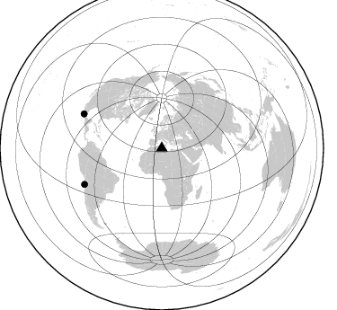
Nearby stations (2 deg radius)
| Station | Name | (Lat, Lon) | Start / End | Elevation |
| GFA | Gafsa, Tunisia | (34.34, 9.07) | 1988-01-01 / 2499-01-01 | 250 m |
| Crust2 Type: | DR,thin Platform 1 km seds. |
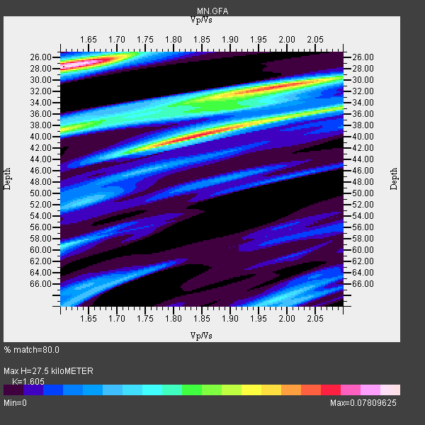
| Thickness Estimate: | 28 km |
| Thickness StdDev: | 10 km |
| Vp/Vs Estimate: | 1.61 |
| Vp/Vs StdDev: | 0.00 |
| Vs Estimate: | 4.091 km/s |
| Poisson's Ratio: | 0.18 |
| Peak Value: | 0.08 |
| Assumed Vp: | 6.567 km/s |
| Ps Weight: | 0.33333334 |
| PpPs Weight: | 0.33333334 |
| PsPs Weight: | 0.33333328 |
| Residual Complexity: | 0.906 |
| Nearby stations H: | +- |
| (2.0 deg) Vp/Vs: | +- |
2 with match > 90% ( 6.6666665 %) and 2 with match > 80% ( 6.6666665 %) out of 30.
Download stack as xyz text file.
Azimuth Distribution of Events:
Prior Results for this Station
| Study | Thickness | Vp/Vs | Vp | Vs | Poissons Ratio | Extra |
| EARS | 28 km | 1.61 | 6.567 km/s | 4.091 km/s | 0.18 | |
| Crust2.0 | 36 km | 1.78 | 6.567 km/s | 3.689 km/s | 0.27 | DR,thin Platform 1 km seds. |
| Global Maxima | 28 km | 1.61 | 6.567 km/s | 4.091 km/s | 0.18 | amp=0.07809625 |
| Local Maxima 1 | 40 km | 1.83 | 6.567 km/s | 3.588 km/s | 0.29 | amp=0.06549841 |
| Local Maxima 2 | 31 km | 1.99 | 6.567 km/s | 3.304 km/s | 0.33 | amp=0.062278245 |
| Local Maxima 3 | 39 km | 1.60 | 6.567 km/s | 4.104 km/s | 0.18 | amp=0.047635555 |
| Local Maxima 4 | 35 km | 2.10 | 6.567 km/s | 3.131 km/s | 0.35 | amp=0.043099284 |
| Predicted Arrivals for vertical incidence (zero ray parameter) | |
| Ps | 2.53 SECOND |
| PpPs | 10.91 SECOND |
| PsPs/PpSs | 13.44 SECOND |
Events Processed for this Station
Download zip of receiver functions as SAC
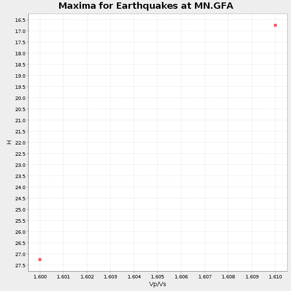
Plot maxima for each earthquake.
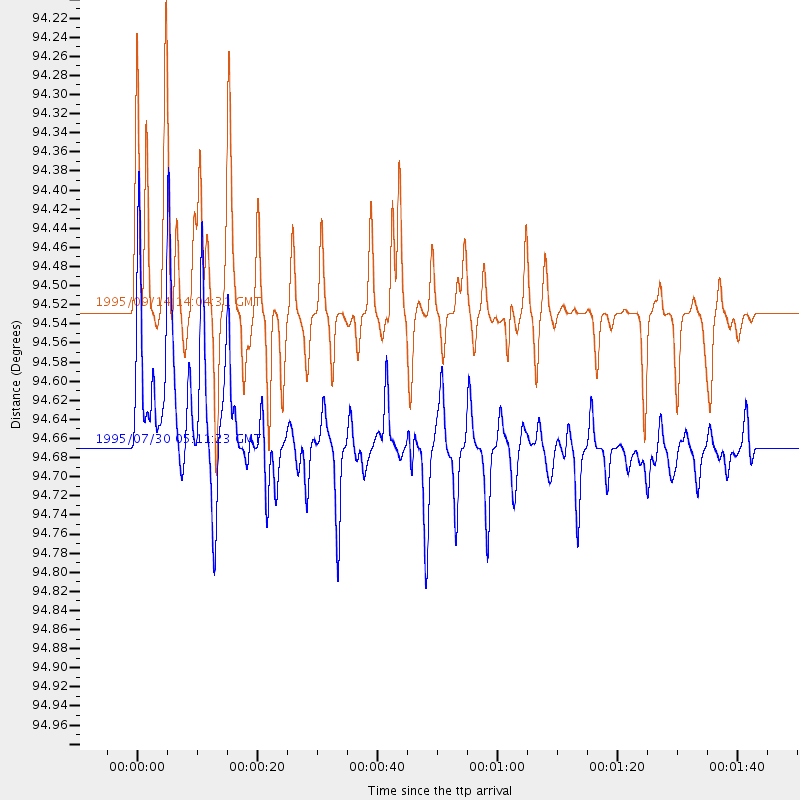
Events Used in the Stack
(2 events)| Radial Match | Distance | Baz | FERegion | Time | Lat/Lon | Depth | Magnitude |
| 94.465614 | 94.7 deg | 244.992 deg | Near Coast Of Northern Chile | 1995/07/30 05:11:23 GMT | (-23.4, -70.3) | 47 km | 6.6 MB, 7.3 MS, 7.2 UNKNOWN, 8.1 MW |
| 91.02449 | 94.5 deg | 293.753 deg | Near Coast Of Guerrero, Mexico | 1995/09/14 14:04:31 GMT | (16.8, -98.6) | 21 km | 6.4 MB, 7.2 MS, 7.2 UNKNOWN, 7.5 MW |
Losers
(28 events)| Radial Match | Distance | Baz | FERegion | Time | Lat/Lon | Depth | Magnitude | Reason |
| 89.77347 | 90.6 deg | 290.826 deg | Chiapas, Mexico | 1995/10/21 02:38:57 GMT | (16.9, -93.5) | 161 km | 6.2 MB, 7.3 UNKNOWN, 7.3 MW | |
| 88.67799 | 96.8 deg | 49.62 deg | Ryukyu Islands, Japan | 1995/10/18 10:37:26 GMT | (27.9, 130.3) | 27 km | 6.5 MB, 6.8 MS, 6.7 UNKNOWN, 7.1 MW | |
| 84.179596 | 81.2 deg | 111.678 deg | South Indian Ocean | 1995/07/27 05:51:17 GMT | (-12.6, 79.2) | 10 km | 6.2 MB, 5.9 MS, 6.0 UNKNOWN, 6.0 MW | |
| 82.9031 | 49.3 deg | 68.952 deg | Hindu Kush Region, Afghanistan | 1995/10/18 09:30:38 GMT | (36.4, 70.4) | 226 km | 5.4 MB, 6.2 UNKNOWN, 6.2 MW | |
| 82.57779 | 49.5 deg | 104.676 deg | Arabian Sea | 1996/03/28 07:28:28 GMT | (11.9, 57.8) | 10 km | 5.8 MB, 5.6 MS, 6.1 UNKNOWN, 5.9 MW | |
| 82.49434 | 96.7 deg | 49.527 deg | Ryukyu Islands, Japan | 1995/10/19 02:41:37 GMT | (28.1, 130.3) | 31 km | 6.3 MB, 6.8 MS, 6.6 UNKNOWN, 6.6 MW | |
| 79.46532 | 75.0 deg | 123.397 deg | Mauritius - Reunion Region | 1995/09/17 17:09:20 GMT | (-17.2, 66.6) | 10 km | 5.4 MB, 6.3 MS, 6.5 UNKNOWN, 6.3 MW | |
| 79.29472 | 94.3 deg | 4.191 deg | Andreanof Islands, Aleutian Is. | 1996/06/10 04:03:35 GMT | (51.6, -177.6) | 33 km | 6.6 MB, 7.6 MS, 7.9 UNKNOWN, 7.4 MS | |
| 79.123436 | 40.0 deg | 359.836 deg | Greenland Sea | 1990/05/27 21:49:32 GMT | (74.3, 8.7) | 10 km | 5.6 MB, 5.4 MS | |
| 78.21535 | 94.7 deg | 245.335 deg | Near Coast Of Northern Chile | 1995/08/03 01:57:21 GMT | (-23.1, -70.6) | 33 km | 5.4 MB, 5.9 MS, 5.7 UNKNOWN, 6.3 MW | |
| 78.20274 | 49.5 deg | 69.519 deg | Hindu Kush Region, Afghanistan | 1990/05/15 14:25:20 GMT | (36.0, 70.4) | 117 km | 6.0 MB | |
| 78.18149 | 87.6 deg | 13.23 deg | Komandorskiye Ostrova Region | 1996/07/16 03:48:28 GMT | (56.1, 165.0) | 33 km | 5.8 MB, 6.4 MS, 6.5 UNKNOWN, 6.3 MW | |
| 73.43925 | 48.5 deg | 82.369 deg | Pakistan | 1990/07/26 06:53:59 GMT | (27.2, 65.5) | 43 km | 5.8 MB, 5.8 MS | |
| 73.19264 | 87.0 deg | 28.91 deg | Sakhalin, Russia | 1990/05/12 04:50:09 GMT | (49.0, 141.9) | 611 km | 6.4 MB | |
| 73.053375 | 94.9 deg | 245.286 deg | Near Coast Of Northern Chile | 1995/07/30 05:25:06 GMT | (-23.2, -70.7) | 33 km | 5.7 MB | |
| 72.200806 | 92.3 deg | 289.749 deg | Off Coast Of Chiapas, Mexico | 1995/09/06 22:48:52 GMT | (15.0, -94.3) | 33 km | 5.8 MB, 5.5 MS | |
| 71.2194 | 94.0 deg | 260.088 deg | Near Coast Of Peru | 1995/09/23 22:31:58 GMT | (-10.5, -78.7) | 73 km | 5.9 MB, 6.5 UNKNOWN, 6.4 MW | |
| 70.644325 | 97.3 deg | 298.549 deg | Near Coast Of Jalisco, Mexico | 1995/10/12 16:52:54 GMT | (18.8, -104.0) | 25 km | 5.5 MB, 5.5 MS, 5.2 UNKNOWN, 6.0 MW | |
| 68.94154 | 90.3 deg | 262.99 deg | Northern Peru | 1990/05/30 02:34:07 GMT | (-6.0, -77.3) | 33 km | 6.0 MB, 6.4 MS, 6.6 UNKNOWN | |
| 68.82337 | 94.3 deg | 6.523 deg | Rat Islands, Aleutian Islands | 1996/03/22 03:24:20 GMT | (51.2, 178.7) | 20 km | 5.7 MB, 6.6 MS, 6.8 UNKNOWN, 6.6 ML | |
| 66.44825 | 97.8 deg | 40.648 deg | Southeast Of Honshu, Japan | 1990/09/23 21:13:06 GMT | (33.2, 138.7) | 10 km | 6.1 MB, 6.5 MS | |
| 63.055668 | 81.6 deg | 86.675 deg | Nicobar Islands, India Region | 1990/08/18 18:52:36 GMT | (7.5, 94.0) | 21 km | 5.5 MB, 5.9 MS | |
| 62.205406 | 95.9 deg | 295.349 deg | Guerrero, Mexico | 1990/05/31 07:35:27 GMT | (17.3, -100.8) | 26 km | 5.8 MB, 5.8 MS, 6.0 UNKNOWN | |
| 62.200993 | 94.8 deg | 245.178 deg | Near Coast Of Northern Chile | 1995/07/30 21:05:50 GMT | (-23.3, -70.6) | 33 km | 5.6 MB, 5.6 MS, 5.4 UNKNOWN, 6.1 MW | |
| 58.81024 | 87.4 deg | 271.057 deg | South Of Panama | 1996/04/27 08:40:41 GMT | (2.4, -79.3) | 10 km | 4.8 MB, 5.9 MS, 6.2 UNKNOWN, 6.0 MW | |
| 53.140335 | 95.5 deg | 199.212 deg | South Sandwich Islands Region | 1990/05/09 04:21:10 GMT | (-56.4, -27.0) | 33 km | 6.1 MB, 5.4 MS | |
| 52.274532 | 89.4 deg | 30.422 deg | Sakhalin, Russia | 1990/08/20 00:03:51 GMT | (46.2, 142.3) | 299 km | 5.9 MB | |
| 43.77896 | 94.3 deg | 1.569 deg | Andreanof Islands, Aleutian Is. | 1995/10/30 20:25:28 GMT | (51.7, -173.4) | 33 km | 5.4 MB, 5.3 MS, 5.8 UNKNOWN, 5.6 ML |
