
Station MN MEB - Medea, Algeria
Network: MN - MEDNET Project
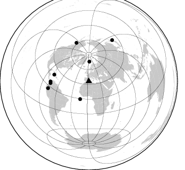
Nearby stations (2 deg radius)
| Station | Name | (Lat, Lon) | Start / End | Elevation |
| MEB | Medea, Algeria | (36.30, 2.73) | 1992-05-20 / 1994-08-31 | 500 m |
| Crust2 Type: | S3,continental slope, margin, transition 3.5 km seds. |
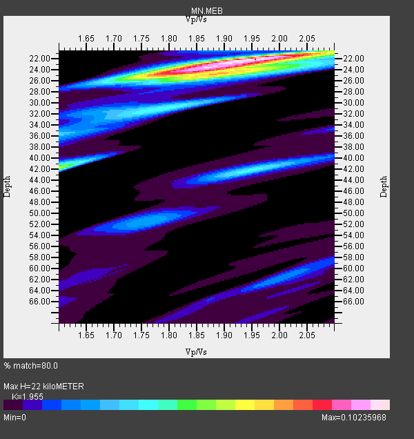
| Thickness Estimate: | 22 km |
| Thickness StdDev: | 2.4 km |
| Vp/Vs Estimate: | 1.96 |
| Vp/Vs StdDev: | 0.07 |
| Vs Estimate: | 3.008 km/s |
| Poisson's Ratio: | 0.32 |
| Peak Value: | 0.10 |
| Assumed Vp: | 5.88 km/s |
| Ps Weight: | 0.33333334 |
| PpPs Weight: | 0.33333334 |
| PsPs Weight: | 0.33333328 |
| Residual Complexity: | 0.605 |
| Nearby stations H: | +- |
| (2.0 deg) Vp/Vs: | +- |
4 with match > 90% ( 16.666666 %) and 8 with match > 80% ( 33.333332 %) out of 24.
Download stack as xyz text file.
Azimuth Distribution of Events:
Prior Results for this Station
| Study | Thickness | Vp/Vs | Vp | Vs | Poissons Ratio | Extra |
| EARS | 22 km | 1.96 | 5.88 km/s | 3.008 km/s | 0.32 | |
| Crust2.0 | 26 km | 1.82 | 5.88 km/s | 3.237 km/s | 0.28 | S3,continental slope, margin, transition 3.5 km seds. |
| Global Maxima | 22 km | 1.96 | 5.88 km/s | 3.008 km/s | 0.32 | amp=0.10235968 |
| Local Maxima 1 | 24 km | 1.83 | 5.88 km/s | 3.222 km/s | 0.29 | amp=0.06668524 |
| Local Maxima 2 | 42 km | 1.60 | 5.88 km/s | 3.675 km/s | 0.18 | amp=0.056991026 |
| Local Maxima 3 | 31 km | 1.78 | 5.88 km/s | 3.304 km/s | 0.27 | amp=0.039424647 |
| Local Maxima 4 | 42 km | 1.95 | 5.88 km/s | 3.016 km/s | 0.32 | amp=0.037982445 |
| Predicted Arrivals for vertical incidence (zero ray parameter) | |
| Ps | 3.57 SECOND |
| PpPs | 11.06 SECOND |
| PsPs/PpSs | 14.63 SECOND |
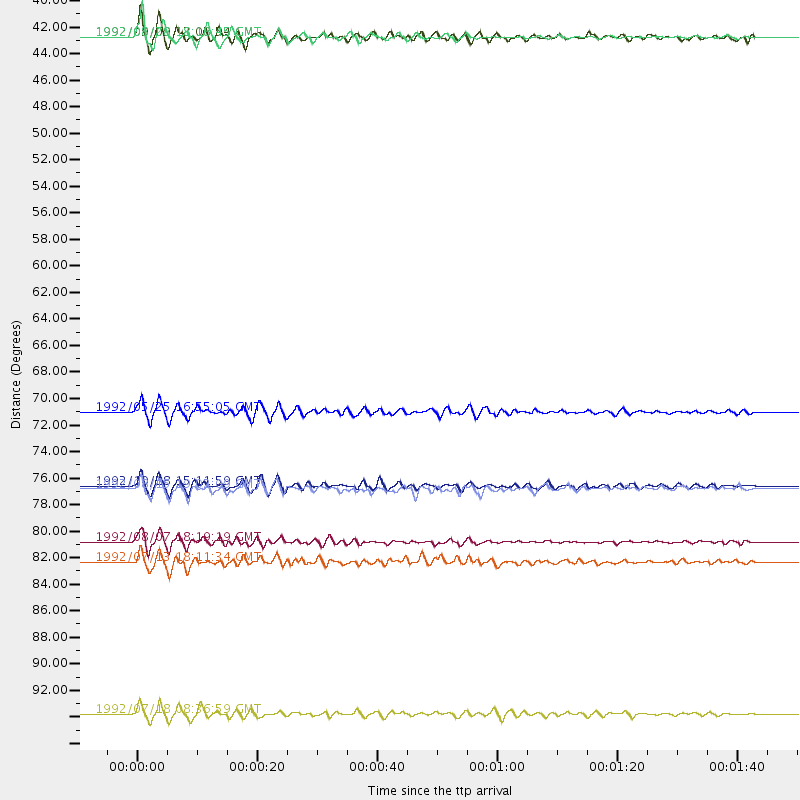
Events Processed for this Station
Download zip of receiver functions as SAC
Plot maxima for each earthquake.
Events Used in the Stack
(8 events)| Radial Match | Distance | Baz | FERegion | Time | Lat/Lon | Depth | Magnitude |
| 95.568726 | 83.8 deg | 260.532 deg | Northern Peru | 1992/07/13 18:11:34 GMT | (-3.9, -76.6) | 100 km | 6.2 MB |
| 92.993385 | 82.1 deg | 342.201 deg | Gulf Of Alaska | 1992/08/07 18:19:19 GMT | (57.6, -143.0) | 10 km | 6.3 MB, 6.5 MS, 6.5 ML |
| 90.89716 | 40.0 deg | 1.681 deg | Svalbard Region | 1992/09/09 13:08:54 GMT | (76.2, 7.2) | 24 km | 5.7 MB, 5.6 MS |
| 90.347466 | 71.3 deg | 280.85 deg | Cuba Region | 1992/05/25 16:55:05 GMT | (19.6, -77.9) | 33 km | 6.3 MB, 7.0 MS |
| 88.46454 | 40.1 deg | 205.814 deg | North Of Ascension Island | 1992/08/28 18:18:45 GMT | (-1.0, -13.6) | 10 km | 6.4 MB, 7.0 MS |
| 87.94079 | 77.7 deg | 267.277 deg | Colombia | 1992/08/15 19:02:09 GMT | (5.1, -75.7) | 127 km | 5.7 MB |
| 84.11783 | 77.5 deg | 269.652 deg | Northern Colombia | 1992/10/18 15:11:59 GMT | (7.1, -76.9) | 10 km | 6.6 MB, 7.3 MS, 7.4 UNKNOWN |
| 81.9107 | 96.4 deg | 29.65 deg | Off East Coast Of Honshu, Japan | 1992/07/18 08:36:59 GMT | (39.4, 143.4) | 33 km | 6.1 MB, 6.9 MS |
Losers
(16 events)| Radial Match | Distance | Baz | FERegion | Time | Lat/Lon | Depth | Magnitude | Reason |
| 84.98503 | 65.9 deg | 59.48 deg | Southern Xinjiang, China | 1993/10/02 08:42:32 GMT | (38.1, 88.6) | 16 km | 6.2 MB, 6.3 MS, 5.8 UNKNOWN, 6.1 MW | |
| 83.879776 | 94.0 deg | 23.077 deg | Kuril Islands | 1992/07/10 09:31:26 GMT | (44.7, 149.5) | 11 km | 6.1 MB, 6.5 MS | |
| 78.7053 | 33.0 deg | 66.019 deg | Eastern Caucasus | 1992/10/23 23:19:47 GMT | (42.5, 45.1) | 33 km | 6.2 MB, 6.5 MS, 6.8 UNKNOWN | |
| 77.66056 | 94.1 deg | 29.427 deg | Hokkaido, Japan Region | 1992/07/12 11:08:56 GMT | (41.4, 142.1) | 70 km | 5.9 MB | |
| 75.82863 | 86.0 deg | 284.939 deg | Near Coast Of Chiapas, Mexico | 1992/05/30 16:30:02 GMT | (14.5, -92.9) | 57 km | 5.6 MB, 6.4 UNKNOWN | |
| 75.293045 | 47.8 deg | 146.969 deg | Democratic Republic Of Congo | 1992/09/11 03:57:26 GMT | (-6.1, 26.7) | 10 km | 6.7 MB, 6.5 MS | |
| 75.045525 | 30.1 deg | 279.968 deg | Azores Islands Region | 1992/11/30 09:32:36 GMT | (35.6, -34.6) | 10 km | 6.0 MB, 5.7 MS | |
| 74.07549 | 95.9 deg | 195.749 deg | South Sandwich Islands Region | 1992/11/21 22:39:35 GMT | (-56.7, -26.5) | 33 km | 5.9 MB, 6.6 MS | |
| 72.27425 | 93.6 deg | 358.449 deg | Andreanof Islands, Aleutian Is. | 1992/08/19 00:57:43 GMT | (50.5, -174.8) | 33 km | 6.1 MB, 5.7 MS, 5.6 ML | |
| 70.69978 | 97.1 deg | 236.206 deg | Near Coast Of Central Chile | 1992/11/28 03:13:37 GMT | (-31.4, -71.9) | 39 km | 5.9 MB, 6.4 MS, 6.0 MD | |
| 70.42695 | 93.2 deg | 30.004 deg | Hokkaido, Japan Region | 1992/08/24 06:59:40 GMT | (41.9, 140.7) | 127 km | 6.2 MB | |
| 65.24877 | 89.7 deg | 14.734 deg | Near East Coast Of Kamchatka | 1992/12/19 12:14:22 GMT | (51.9, 158.5) | 56 km | 6.1 MB | |
| 64.15194 | 92.7 deg | 36.454 deg | Sea Of Japan | 1993/01/19 14:39:26 GMT | (38.6, 133.5) | 455 km | 6.0 MB | |
| 56.707462 | 96.9 deg | 235.812 deg | Near Coast Of Central Chile | 1992/11/04 21:32:36 GMT | (-31.6, -71.6) | 37 km | 5.8 MB, 5.8 MS, 5.3 MD | |
| 51.708977 | 82.5 deg | 272.056 deg | South Of Panama | 1992/06/26 11:32:30 GMT | (6.1, -82.4) | 33 km | 5.8 MB, 5.4 MS | |
| 49.170788 | 53.7 deg | 68.095 deg | Hindu Kush Region, Afghanistan | 1992/11/12 20:41:04 GMT | (36.5, 70.8) | 198 km | 5.6 MB |
