
Station MP AMR2 - Amara, Iraq
Network: MP - Iraqi Seismic Observatory
Nearby stations (2 deg radius)
| Station | Name | (Lat, Lon) | Start / End | Elevation |
| AMR2 | Amara, Iraq | (31.99, 47.19) | 2015-11-07 / 2599-12-31 | 9.0 m |
| Crust2 Type: | DX,Platform 9 km seds. |
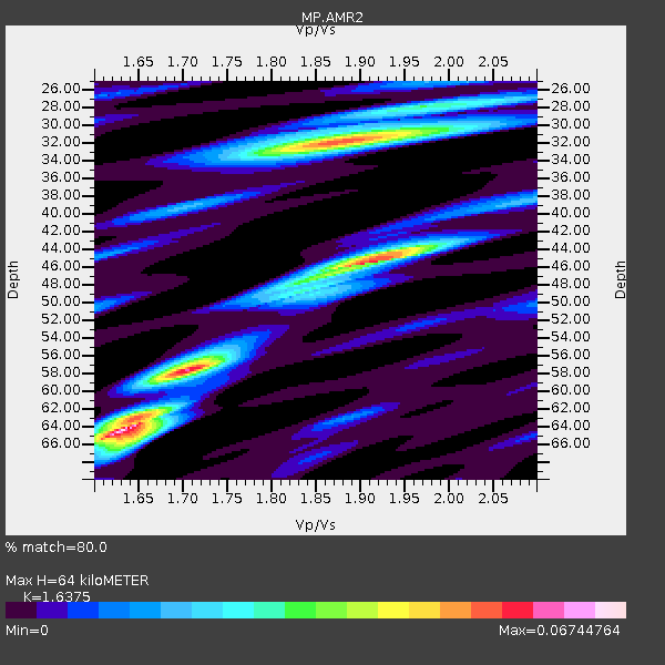
| Thickness Estimate: | 64 km |
| Thickness StdDev: | 15 km |
| Vp/Vs Estimate: | 1.64 |
| Vp/Vs StdDev: | 0.11 |
| Vs Estimate: | 3.767 km/s |
| Poisson's Ratio: | 0.20 |
| Peak Value: | 0.07 |
| Assumed Vp: | 6.168 km/s |
| Ps Weight: | 0.33333334 |
| PpPs Weight: | 0.33333334 |
| PsPs Weight: | 0.33333328 |
| Residual Complexity: | 0.822 |
| Nearby stations H: | +- |
| (2.0 deg) Vp/Vs: | +- |
0 with match > 90% ( 0.0 %) and 4 with match > 80% ( 9.523809 %) out of 42.
Download stack as xyz text file.
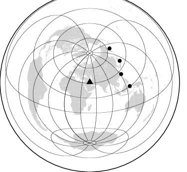
Azimuth Distribution of Events:
Prior Results for this Station
| Study | Thickness | Vp/Vs | Vp | Vs | Poissons Ratio | Extra |
| EARS | 64 km | 1.64 | 6.168 km/s | 3.767 km/s | 0.20 | |
| Crust2.0 | 41 km | 1.77 | 6.168 km/s | 3.476 km/s | 0.27 | DX,Platform 9 km seds. |
| Global Maxima | 64 km | 1.64 | 6.168 km/s | 3.767 km/s | 0.20 | amp=0.06744764 |
| Local Maxima 1 | 32 km | 1.88 | 6.168 km/s | 3.285 km/s | 0.30 | amp=0.052927975 |
| Local Maxima 2 | 46 km | 1.90 | 6.168 km/s | 3.242 km/s | 0.31 | amp=0.052881323 |
| Local Maxima 3 | 58 km | 1.70 | 6.168 km/s | 3.623 km/s | 0.24 | amp=0.038470812 |
| Local Maxima 4 | 28 km | 1.97 | 6.168 km/s | 3.131 km/s | 0.33 | amp=0.02046838 |
| Predicted Arrivals for vertical incidence (zero ray parameter) | |
| Ps | 6.61 SECOND |
| PpPs | 27.37 SECOND |
| PsPs/PpSs | 33.98 SECOND |
Events Processed for this Station
Download zip of receiver functions as SAC
Plot maxima for each earthquake.
Events Used in the Stack
(4 events)| Radial Match | Distance | Baz | FERegion | Time | Lat/Lon | Depth | Magnitude |
| 87.707405 | 65.0 deg | 75.406 deg | Taiwan Region | 2020/12/10 13:19:58 UTC | (24.8, 122.0) | 73 km | 6.1 mww |
| 86.523285 | 74.0 deg | 54.492 deg | Near East Coast Of Honshu, Japan | 2021/03/20 09:09:45 UTC | (38.5, 141.6) | 54 km | 7.0 Mww |
| 83.08199 | 80.4 deg | 95.401 deg | Northern Molucca Sea | 2019/07/07 15:08:40 UTC | (0.5, 126.2) | 36 km | 6.9 Mww |
| 80.08805 | 78.7 deg | 30.485 deg | Komandorskiye Ostrova Region | 2018/01/25 02:10:33 UTC | (55.4, 166.5) | 8.8 km | 6.2 Mww |
Losers
(38 events)| Radial Match | Distance | Baz | FERegion | Time | Lat/Lon | Depth | Magnitude | Reason |
| 84.064476 | 76.0 deg | 262.243 deg | Central Mid-Atlantic Ridge | 2020/09/18 21:43:59 UTC | (1.0, -26.8) | 10 km | 6.9 Mww | |
| 82.32922 | 70.1 deg | 113.051 deg | Java, Indonesia | 2017/12/15 16:47:56 UTC | (-7.7, 108.0) | 92 km | 6.5 Mww | |
| 79.740234 | 84.5 deg | 97.666 deg | Seram, Indonesia | 2019/09/26 00:39:59 UTC | (-3.6, 128.5) | 11 km | 5.4 Mww | |
| 78.85626 | 49.9 deg | 90.753 deg | Laos | 2019/11/20 23:50:44 UTC | (19.5, 101.3) | 10 km | 6.1 Mww | |
| 74.25526 | 80.4 deg | 95.142 deg | Northern Molucca Sea | 2020/01/29 23:46:54 UTC | (0.7, 126.3) | 15 km | 5.7 mww | |
| 73.82764 | 68.9 deg | 86.571 deg | Mindoro, Philippines | 2020/12/24 23:43:42 UTC | (13.8, 120.6) | 114 km | 6.3 Mww | |
| 73.21194 | 73.7 deg | 51.586 deg | Hokkaido, Japan Region | 2019/08/28 23:46:39 UTC | (41.1, 143.0) | 17 km | 6.1 Mww | |
| 72.377785 | 78.2 deg | 90.442 deg | Mindanao, Philippines | 2019/01/15 20:03:20 UTC | (5.9, 126.9) | 61 km | 5.8 Mww | |
| 71.85599 | 77.3 deg | 91.781 deg | Mindanao, Philippines | 2020/12/15 23:21:59 UTC | (5.2, 125.4) | 27 km | 6.1 mww | |
| 71.54388 | 70.6 deg | 50.19 deg | Eastern Sea Of Japan | 2021/01/12 02:39:42 UTC | (43.7, 140.0) | 211 km | 5.9 mww | |
| 71.02404 | 85.4 deg | 90.948 deg | Irian Jaya Region, Indonesia | 2019/11/23 12:11:16 UTC | (1.6, 132.8) | 10 km | 6.1 Mww | |
| 69.67127 | 76.0 deg | 88.009 deg | Mindanao, Philippines | 2020/07/27 17:32:44 UTC | (9.0, 126.3) | 39 km | 5.7 Mww | |
| 69.54925 | 76.2 deg | 88.261 deg | Mindanao, Philippines | 2020/11/15 22:37:45 UTC | (8.7, 126.3) | 59 km | 5.9 mww | |
| 69.30614 | 89.0 deg | 25.301 deg | Andreanof Islands, Aleutian Is. | 2019/11/24 00:54:03 UTC | (51.2, -175.6) | 34 km | 5.6 Mi | |
| 68.86195 | 90.4 deg | 15.25 deg | South Of Alaska | 2020/10/06 05:54:50 UTC | (54.8, -159.9) | 30 km | 5.6 ml | |
| 67.35871 | 84.5 deg | 105.717 deg | Timor Region | 2020/01/15 07:55:29 UTC | (-10.4, 124.1) | 10 km | 5.5 Mww | |
| 66.42373 | 79.3 deg | 62.227 deg | Southeast Of Honshu, Japan | 2017/12/21 03:00:19 UTC | (29.3, 142.7) | 16 km | 5.7 Mww | |
| 64.726776 | 56.6 deg | 113.739 deg | Northern Sumatra, Indonesia | 2018/11/29 20:21:44 UTC | (0.3, 97.0) | 8.8 km | 5.7 Mww | |
| 64.72317 | 70.3 deg | 113.316 deg | Java, Indonesia | 2020/10/25 00:56:47 UTC | (-8.0, 108.0) | 57 km | 5.4 Mww | |
| 64.67025 | 87.7 deg | 286.846 deg | North Atlantic Ocean | 2018/11/27 19:34:46 UTC | (15.6, -49.9) | 10 km | 5.5 Mww | |
| 63.91043 | 82.5 deg | 64.325 deg | Volcano Islands, Japan Region | 2019/01/05 22:54:13 UTC | (25.8, 144.6) | 8.3 km | 5.8 Mww | |
| 63.384445 | 81.9 deg | 64.917 deg | Volcano Islands, Japan Region | 2020/11/07 01:10:32 UTC | (25.7, 143.6) | 18 km | 5.8 mww | |
| 63.341713 | 61.5 deg | 114.582 deg | Southern Sumatra, Indonesia | 2020/10/19 07:47:20 UTC | (-3.4, 100.3) | 10 km | 5.5 Mww | |
| 63.172768 | 83.2 deg | 95.406 deg | Halmahera, Indonesia | 2019/09/14 16:21:29 UTC | (-1.0, 128.5) | 10 km | 5.9 Mww | |
| 62.774998 | 57.3 deg | 308.747 deg | Northern Mid-Atlantic Ridge | 2021/03/20 01:49:18 UTC | (47.3, -27.3) | 10 km | 5.8 Mww | |
| 61.906807 | 84.4 deg | 67.069 deg | Volcano Islands, Japan Region | 2020/12/08 00:47:22 UTC | (22.5, 144.8) | 10 km | 5.3 mww | |
| 61.380436 | 87.3 deg | 27.443 deg | Andreanof Islands, Aleutian Is. | 2020/01/26 22:33:40 UTC | (51.3, -180.0) | 35 km | 5.7 Mww | |
| 58.47315 | 47.6 deg | 109.8 deg | Nicobar Islands, India Region | 2018/01/25 01:15:58 UTC | (8.3, 91.8) | 10 km | 5.9 Mww | |
| 57.05496 | 38.6 deg | 77.603 deg | Xizang | 2021/03/19 06:11:27 UTC | (31.9, 92.9) | 10 km | 5.7 Mww | |
| 56.779133 | 49.4 deg | 78.196 deg | Sichuan, China | 2019/07/04 02:17:58 UTC | (28.5, 104.9) | 10 km | 5.2 Mww | |
| 56.571033 | 39.6 deg | 144.032 deg | Carlsberg Ridge | 2021/03/17 00:04:58 UTC | (-1.8, 69.2) | 10 km | 5.6 mww | |
| 54.61494 | 74.5 deg | 48.226 deg | Hokkaido, Japan Region | 2020/01/28 01:36:02 UTC | (43.6, 145.9) | 79 km | 5.5 mb | |
| 52.979126 | 72.2 deg | 109.231 deg | Java, Indonesia | 2019/09/19 07:32:00 UTC | (-6.1, 111.9) | 591 km | 6.0 Mww | |
| 48.651936 | 68.1 deg | 68.357 deg | Northwest Of Ryukyu Islands | 2019/07/13 00:57:44 UTC | (29.4, 128.2) | 251 km | 6.1 Mww | |
| 46.1256 | 77.3 deg | 188.821 deg | Prince Edward Islands Region | 2019/10/13 12:21:07 UTC | (-44.9, 35.0) | 10 km | 5.4 Mww | |
| 43.72059 | 76.6 deg | 88.26 deg | Mindanao, Philippines | 2020/07/31 06:06:41 UTC | (8.5, 126.6) | 28 km | 5.7 Mww | |
| 40.80623 | 72.2 deg | 109.183 deg | Java, Indonesia | 2019/09/19 07:32:58 UTC | (-6.0, 111.9) | 638 km | 5.7 mb | |
| 21.749588 | 87.0 deg | 100.155 deg | Banda Sea | 2020/11/01 03:43:20 UTC | (-7.1, 129.2) | 181 km | 5.7 Mww |

