
Station MP SAM2 - Samawa-2
Network: MP - Iraqi Seismic Observatory
Nearby stations (2 deg radius)
| Station | Name | (Lat, Lon) | Start / End | Elevation |
| SAM2 | Samawa-2 | (30.53, 44.56) | 2023-03-04 / 2499-01-01 | 0.0 m |
| Crust2 Type: | IC,thin late Proter., 7 km seds. |
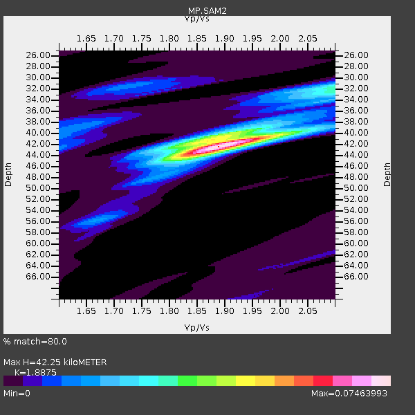
| Thickness Estimate: | 42 km |
| Thickness StdDev: | 1.0 km |
| Vp/Vs Estimate: | 1.89 |
| Vp/Vs StdDev: | 0.02 |
| Vs Estimate: | 3.262 km/s |
| Poisson's Ratio: | 0.30 |
| Peak Value: | 0.07 |
| Assumed Vp: | 6.157 km/s |
| Ps Weight: | 0.33333334 |
| PpPs Weight: | 0.33333334 |
| PsPs Weight: | 0.33333328 |
| Residual Complexity: | 0.486 |
| Nearby stations H: | +- |
| (2.0 deg) Vp/Vs: | +- |
0 with match > 90% ( 0.0 %) and 4 with match > 80% ( 11.111111 %) out of 36.
Download stack as xyz text file.
Azimuth Distribution of Events:

Prior Results for this Station
| Study | Thickness | Vp/Vs | Vp | Vs | Poissons Ratio | Extra |
| EARS | 42 km | 1.89 | 6.157 km/s | 3.262 km/s | 0.30 | |
| Crust2.0 | 36 km | 1.78 | 6.157 km/s | 3.46 km/s | 0.27 | IC,thin late Proter., 7 km seds. |
| Global Maxima | 42 km | 1.89 | 6.157 km/s | 3.262 km/s | 0.30 | amp=0.07463993 |
| Local Maxima 1 | 41 km | 1.86 | 6.157 km/s | 3.315 km/s | 0.30 | amp=0.03542761 |
| Local Maxima 2 | 32 km | 2.09 | 6.157 km/s | 2.946 km/s | 0.35 | amp=0.029972645 |
| Local Maxima 3 | 39 km | 1.61 | 6.157 km/s | 3.818 km/s | 0.19 | amp=0.014618746 |
| Local Maxima 4 | 44 km | 1.85 | 6.157 km/s | 3.333 km/s | 0.29 | amp=0.014442185 |
| Predicted Arrivals for vertical incidence (zero ray parameter) | |
| Ps | 6.09 SECOND |
| PpPs | 19.81 SECOND |
| PsPs/PpSs | 25.90 SECOND |
Events Processed for this Station
Download zip of receiver functions as SAC
Plot maxima for each earthquake.
Events Used in the Stack
(4 events)| Radial Match | Distance | Baz | FERegion | Time | Lat/Lon | Depth | Magnitude |
| 87.548904 | 77.3 deg | 53.731 deg | Near East Coast Of Honshu, Japan | 2024/04/04 03:16:31 UTC | (37.7, 141.9) | 40 km | 6.1 Mww |
| 83.39554 | 82.2 deg | 91.447 deg | Northern Molucca Sea | 2024/04/09 09:48:01 UTC | (2.7, 127.1) | 35 km | 6.6 mww |
| 82.84842 | 73.3 deg | 295.057 deg | Northern Mid-Atlantic Ridge | 2024/03/14 21:10:25 UTC | (29.8, -42.7) | 10 km | 6.0 mww |
| 81.64443 | 82.3 deg | 227.371 deg | Southern Mid-Atlantic Ridge | 2024/06/14 04:26:48 UTC | (-30.9, -13.5) | 10 km | 5.9 Mww |
Losers
(32 events)| Radial Match | Distance | Baz | FERegion | Time | Lat/Lon | Depth | Magnitude | Reason |
| 96.08523 | 67.6 deg | 74.408 deg | Taiwan | 2024/04/03 00:46:44 UTC | (24.1, 121.7) | 10 km | 5.7 mb | |
| 79.312325 | 76.0 deg | 51.63 deg | Near East Coast Of Honshu, Japan | 2024/04/01 19:24:36 UTC | (40.1, 141.7) | 73 km | 5.9 mww | |
| 74.31347 | 55.5 deg | 109.501 deg | Off W Coast Of Northern Sumatra | 2024/05/28 11:52:39 UTC | (2.8, 95.6) | 18 km | 5.9 mww | |
| 67.30887 | 35.3 deg | 72.915 deg | Xizang | 2024/06/01 00:46:37 UTC | (34.2, 86.4) | 13 km | 5.6 mb | |
| 66.50633 | 63.4 deg | 112.026 deg | Southern Sumatra, Indonesia | 2024/06/05 02:20:26 UTC | (-3.6, 100.7) | 10 km | 5.6 mww | |
| 65.91392 | 72.7 deg | 66.919 deg | Ryukyu Islands, Japan | 2024/03/15 10:32:48 UTC | (28.4, 130.1) | 10 km | 5.6 mb | |
| 65.87589 | 32.5 deg | 58.758 deg | Northern Xinjiang, China | 2024/04/10 14:56:17 UTC | (42.0, 82.6) | 6.5 km | 5.4 Mww | |
| 65.19631 | 78.1 deg | 92.555 deg | Celebes Sea | 2024/05/18 06:26:09 UTC | (3.9, 123.0) | 528 km | 5.5 Mww | |
| 63.16311 | 88.5 deg | 94.665 deg | Seram, Indonesia | 2024/05/05 20:37:11 UTC | (-3.3, 130.9) | 10 km | 5.5 Mww | |
| 62.762554 | 88.3 deg | 26.429 deg | Rat Islands, Aleutian Islands | 2024/03/30 16:28:57 UTC | (52.1, 178.4) | 115 km | 5.8 mww | |
| 60.65078 | 67.7 deg | 74.772 deg | Taiwan | 2024/04/23 00:04:05 UTC | (23.8, 121.7) | 13 km | 5.8 mww | |
| 60.573208 | 67.7 deg | 74.887 deg | Taiwan | 2024/04/22 14:11:22 UTC | (23.7, 121.6) | 8.0 km | 5.8 mww | |
| 60.438206 | 76.7 deg | 60.342 deg | Southeast Of Honshu, Japan | 2024/05/29 17:14:58 UTC | (32.3, 137.6) | 392 km | 5.5 Mww | |
| 58.32943 | 80.8 deg | 90.303 deg | Talaud Islands, Indonesia | 2024/06/12 17:01:20 UTC | (4.4, 126.5) | 34 km | 5.8 Mww | |
| 58.23388 | 38.7 deg | 65.361 deg | Southern Xinjiang, China | 2024/04/04 00:39:38 UTC | (38.5, 90.9) | 10 km | 5.1 Mww | |
| 56.90367 | 67.7 deg | 74.893 deg | Taiwan | 2024/05/06 09:52:45 UTC | (23.7, 121.6) | 29 km | 5.4 Mwr | |
| 54.208187 | 44.9 deg | 86.349 deg | Myanmar-India Border Region | 2024/05/29 13:13:27 UTC | (23.5, 94.7) | 98 km | 5.4 Mww | |
| 53.799255 | 31.7 deg | 74.654 deg | Xizang | 2024/04/13 05:44:39 UTC | (33.5, 81.9) | 10 km | 5.5 mb | |
| 53.299435 | 76.6 deg | 85.185 deg | Leyte, Philippines | 2024/05/03 10:16:23 UTC | (10.9, 125.3) | 7.9 km | 5.7 Mww | |
| 53.253 | 67.7 deg | 74.886 deg | Taiwan | 2024/05/06 09:45:30 UTC | (23.7, 121.6) | 20 km | 5.6 Mww | |
| 53.146355 | 74.1 deg | 55.744 deg | Near West Coast Of Honshu, Japan | 2024/06/02 21:31:38 UTC | (37.5, 137.2) | 4.8 km | 5.8 mww | |
| 53.096516 | 78.8 deg | 86.308 deg | Mindanao, Philippines | 2024/03/01 09:29:02 UTC | (8.8, 126.7) | 35 km | 5.3 Mww | |
| 51.480858 | 82.0 deg | 94.852 deg | Southern Molucca Sea | 2024/03/13 18:56:13 UTC | (-0.1, 125.2) | 26 km | 5.8 mww | |
| 51.269547 | 67.8 deg | 74.3 deg | Taiwan | 2024/05/10 07:45:18 UTC | (24.2, 121.9) | 11 km | 5.8 mww | |
| 49.829643 | 74.9 deg | 40.496 deg | Sea Of Okhotsk | 2024/06/06 11:07:53 UTC | (50.1, 147.6) | 622 km | 5.9 mww | |
| 48.77773 | 64.1 deg | 251.933 deg | North Of Ascension Island | 2024/05/04 05:52:35 UTC | (-1.2, -14.3) | 10 km | 5.4 Mww | |
| 48.03856 | 72.3 deg | 63.382 deg | Kyushu, Japan | 2024/04/08 01:25:29 UTC | (31.7, 131.4) | 54 km | 5.1 Mww | |
| 46.12544 | 76.6 deg | 50.354 deg | Off East Coast Of Honshu, Japan | 2024/04/06 00:12:17 UTC | (40.9, 143.2) | 19 km | 5.4 Mww | |
| 45.585323 | 77.3 deg | 54.418 deg | Near East Coast Of Honshu, Japan | 2024/03/16 21:17:04 UTC | (37.1, 141.5) | 45 km | 5.3 Mww | |
| 41.329296 | 92.3 deg | 70.19 deg | Mariana Islands | 2024/04/02 22:16:44 UTC | (15.9, 146.9) | 10 km | 5.2 Mww | |
| 34.70904 | 65.9 deg | 112.967 deg | Southern Sumatra, Indonesia | 2024/03/04 02:48:21 UTC | (-5.8, 102.2) | 10 km | 5.5 mb | |
| 21.904524 | 77.0 deg | 54.59 deg | Near East Coast Of Honshu, Japan | 2024/03/14 15:14:36 UTC | (37.1, 141.1) | 53 km | 5.6 mww |

