
Station MX TLIG - Tlapa, Gro. MX
Network: MX - Mexican National Seismic Network
Nearby stations (2 deg radius)
| Station | Name | (Lat, Lon) | Start / End | Elevation |
| TLIG | Tlapa, Gro. MX | (17.56, -98.57) | 2009-01-01 / 2599-12-31 | 1136 m |
| Crust2 Type: | L8,thin continental arc, Cordilleras, 0.5 km seds. |
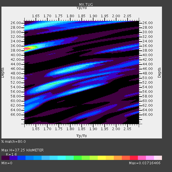
| Thickness Estimate: | 37 km |
| Thickness StdDev: | 8.6 km |
| Vp/Vs Estimate: | 1.60 |
| Vp/Vs StdDev: | 0.14 |
| Vs Estimate: | 4.104 km/s |
| Poisson's Ratio: | 0.18 |
| Peak Value: | 0.04 |
| Assumed Vp: | 6.566 km/s |
| Ps Weight: | 0.33333334 |
| PpPs Weight: | 0.33333334 |
| PsPs Weight: | 0.33333328 |
| Residual Complexity: | 0.865 |
| Nearby stations H: | +- |
| (2.0 deg) Vp/Vs: | +- |
2 with match > 90% ( 15.384615 %) and 3 with match > 80% ( 23.076923 %) out of 13.
Download stack as xyz text file.
Azimuth Distribution of Events:

Prior Results for this Station
| Study | Thickness | Vp/Vs | Vp | Vs | Poissons Ratio | Extra |
| EARS | 37 km | 1.60 | 6.566 km/s | 4.104 km/s | 0.18 | |
| Crust2.0 | 34 km | 1.77 | 6.566 km/s | 3.707 km/s | 0.27 | L8,thin continental arc, Cordilleras, 0.5 km seds. |
| Global Maxima | 37 km | 1.60 | 6.566 km/s | 4.104 km/s | 0.18 | amp=0.03716466 |
| Local Maxima 1 | 52 km | 1.73 | 6.566 km/s | 3.806 km/s | 0.25 | amp=0.017951282 |
| Local Maxima 2 | 28 km | 1.62 | 6.566 km/s | 4.053 km/s | 0.19 | amp=0.014944324 |
| Local Maxima 3 | 44 km | 1.85 | 6.566 km/s | 3.559 km/s | 0.29 | amp=0.013710523 |
| Local Maxima 4 | 55 km | 1.85 | 6.566 km/s | 3.549 km/s | 0.29 | amp=0.012479522 |
| Predicted Arrivals for vertical incidence (zero ray parameter) | |
| Ps | 3.40 SECOND |
| PpPs | 14.75 SECOND |
| PsPs/PpSs | 18.15 SECOND |
Events Processed for this Station
Download zip of receiver functions as SAC
Plot maxima for each earthquake.
Events Used in the Stack
(3 events)| Radial Match | Distance | Baz | FERegion | Time | Lat/Lon | Depth | Magnitude |
| 95.47128 | 71.9 deg | 319.609 deg | Rat Islands, Aleutian Islands | 2014/06/23 20:53:09 GMT | (51.8, 178.8) | 108 km | 7.9 MWW, 7.1 MI, 7.9 MWC |
| 94.179 | 40.4 deg | 140.825 deg | Central Peru | 2014/08/24 23:21:45 GMT | (-14.6, -73.6) | 101 km | 6.9 MWW, 6.8 MI, 6.9 MWB |
| 84.47199 | 88.8 deg | 237.566 deg | Kermadec Islands Region | 2014/07/03 19:50:05 GMT | (-30.5, -176.5) | 20 km | 6.3 MWB, 6.6 MI |
Losers
(10 events)| Radial Match | Distance | Baz | FERegion | Time | Lat/Lon | Depth | Magnitude | Reason |
| 88.65959 | 46.7 deg | 142.398 deg | Near Coast Of Northern Chile | 2014/07/13 20:54:14 GMT | (-20.2, -70.4) | 36 km | 6.1 M | |
| 82.71036 | 72.0 deg | 319.79 deg | Rat Islands, Aleutian Islands | 2014/06/23 22:29:51 GMT | (52.0, 178.6) | 103 km | 5.9 MB | |
| 73.48847 | 47.7 deg | 142.879 deg | Northern Chile | 2014/05/30 15:32:27 GMT | (-21.3, -70.0) | 57 km | 5.6 MWW, 5.5 MWR, 5.6 MWB | |
| 72.48091 | 93.0 deg | 318.727 deg | Kuril Islands | 2014/07/20 18:32:47 GMT | (44.6, 148.7) | 61 km | 6.6 MB | |
| 69.62763 | 36.4 deg | 84.868 deg | Leeward Islands | 2014/05/16 11:01:42 GMT | (17.1, -60.4) | 24 km | 6.0 MWP, 6.0 MI | |
| 64.547264 | 46.0 deg | 142.607 deg | Near Coast Of Northern Chile | 2014/06/20 20:22:28 GMT | (-19.8, -70.9) | 16 km | 5.6 MB | |
| 61.3965 | 93.7 deg | 147.367 deg | South Sandwich Islands Region | 2014/07/12 17:49:17 GMT | (-55.4, -28.0) | 5.5 km | 5.5 MWB | |
| 60.019382 | 49.8 deg | 335.296 deg | Southeastern Alaska | 2014/06/04 11:58:58 GMT | (59.0, -136.7) | 10 km | 5.7 MWP, 5.8 ML, 5.8 MI | |
| 59.601925 | 64.1 deg | 337.803 deg | Northern Alaska | 2014/06/07 04:43:34 GMT | (67.9, -162.4) | 14 km | 6.0 MI | |
| 54.396214 | 63.9 deg | 337.66 deg | Northern Alaska | 2014/06/16 12:01:11 GMT | (67.7, -162.0) | 16 km | 5.7 MB, 5.5 MWP, 5.5 MI |
