
Station MZ CNG - Changalane, Mozambique
Network: MZ - National Seismic Network of Mozambique (INAMI)
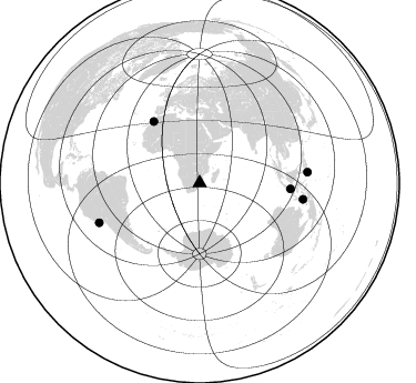
Nearby stations (2 deg radius)
| Station | Name | (Lat, Lon) | Start / End | Elevation |
| CNG | Changalane, Mozambique | (-26.17, 32.11) | 2022-07-01 / 2499-01-01 | 100 m |
| CNG | MBB2 ES-T | (-26.17, 32.11) | 2022-06-27 / 2499-01-01 | 100 m |
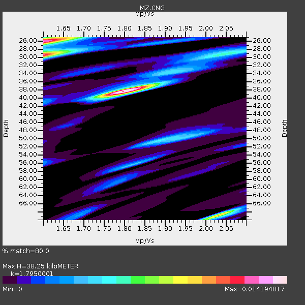
| Crust2 Type: | C4,continental shelf, 3.5 km seds. |
| Thickness Estimate: | 38 km |
| Thickness StdDev: | 13 km |
| Vp/Vs Estimate: | 1.80 |
| Vp/Vs StdDev: | 0.13 |
| Vs Estimate: | 3.323 km/s |
| Poisson's Ratio: | 0.28 |
| Peak Value: | 0.01 |
| Assumed Vp: | 5.989 km/s |
| Ps Weight: | 0.33333334 |
| PpPs Weight: | 0.33333334 |
| PsPs Weight: | 0.33333328 |
| Residual Complexity: | 0.664 |
| Nearby stations H: | +- |
| (2.0 deg) Vp/Vs: | +- |
1 with match > 90% ( 2.3809524 %) and 5 with match > 80% ( 11.904762 %) out of 42.
Download stack as xyz text file.
Azimuth Distribution of Events:
Prior Results for this Station
| Study | Thickness | Vp/Vs | Vp | Vs | Poissons Ratio | Extra |
| EARS | 38 km | 1.80 | 5.989 km/s | 3.323 km/s | 0.28 | |
| Crust2.0 | 32 km | 1.81 | 5.989 km/s | 3.317 km/s | 0.28 | C4,continental shelf, 3.5 km seds. |
| Global Maxima | 38 km | 1.80 | 5.989 km/s | 3.323 km/s | 0.28 | amp=0.012668547 |
| Local Maxima 1 | 26 km | 1.61 | 5.989 km/s | 3.726 km/s | 0.18 | amp=0.009475397 |
| Local Maxima 2 | 30 km | 1.60 | 5.989 km/s | 3.737 km/s | 0.18 | amp=0.008622533 |
| Local Maxima 3 | 50 km | 1.87 | 5.989 km/s | 3.198 km/s | 0.30 | amp=0.0051181396 |
| Local Maxima 4 | 69 km | 2.03 | 5.989 km/s | 2.95 km/s | 0.34 | amp=0.0049053077 |
| Predicted Arrivals for vertical incidence (zero ray parameter) | |
| Ps | 5.09 SECOND |
| PpPs | 17.78 SECOND |
| PsPs/PpSs | 22.87 SECOND |
Events Processed for this Station
Download zip of receiver functions as SAC
Plot maxima for each earthquake.
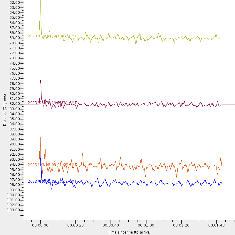
Events Used in the Stack
(5 events)| Radial Match | Distance | Baz | FERegion | Time | Lat/Lon | Depth | Magnitude |
| 97.206184 | 68.9 deg | 323.293 deg | Morocco | 2023/09/08 22:11:01 UTC | (31.1, -8.4) | 19 km | 6.8 mww |
| 88.066 | 82.1 deg | 93.662 deg | Bali Sea | 2023/08/28 19:55:31 UTC | (-6.8, 116.5) | 514 km | 7.1 Mww |
| 85.34453 | 97.6 deg | 84.236 deg | Mindanao, Philippines | 2023/12/02 14:37:03 UTC | (8.5, 126.4) | 33 km | 7.6 mww |
| 80.3432 | 97.3 deg | 248.49 deg | Near Coast Of Peru | 2024/06/28 05:36:37 UTC | (-15.8, -74.4) | 28 km | 7.2 mww |
| 80.10379 | 94.3 deg | 98.929 deg | Banda Sea | 2023/11/08 13:02:06 UTC | (-6.1, 129.9) | 10 km | 6.7 mww |
Losers
(37 events)| Radial Match | Distance | Baz | FERegion | Time | Lat/Lon | Depth | Magnitude | Reason |
| 87.94011 | 66.7 deg | 26.512 deg | Northwestern Afghanistan | 2023/10/07 07:12:50 UTC | (34.5, 61.9) | 11 km | 6.2 mww | |
| 80.89936 | 42.1 deg | 239.163 deg | Southern Mid-Atlantic Ridge | 2023/08/25 20:47:24 UTC | (-39.6, -16.0) | 10 km | 5.5 Mww | |
| 76.64192 | 95.0 deg | 86.277 deg | Mindanao, Philippines | 2023/11/17 08:14:11 UTC | (5.6, 125.0) | 64 km | 6.7 Mww | |
| 75.18029 | 97.8 deg | 84.477 deg | Mindanao, Philippines | 2023/12/02 16:03:43 UTC | (8.4, 126.8) | 64 km | 6.4 Mww | |
| 72.85434 | 66.8 deg | 26.643 deg | Northwestern Afghanistan | 2023/10/11 00:41:56 UTC | (34.6, 62.1) | 10 km | 6.3 Mww | |
| 71.272934 | 52.0 deg | 213.399 deg | South Sandwich Islands Region | 2024/05/31 08:35:04 UTC | (-59.6, -26.5) | 53 km | 5.6 mb | |
| 69.088585 | 72.1 deg | 31.792 deg | Hindu Kush Region, Afghanistan | 2024/01/11 09:20:26 UTC | (36.5, 70.6) | 207 km | 6.4 Mww | |
| 68.64674 | 85.1 deg | 163.499 deg | Balleny Islands Region | 2023/10/11 03:54:56 UTC | (-63.8, 172.5) | 10 km | 5.5 mb | |
| 68.510796 | 51.7 deg | 290.185 deg | North Of Ascension Island | 2024/03/26 13:14:08 UTC | (-1.6, -15.4) | 10 km | 5.4 mww | |
| 68.37023 | 57.0 deg | 77.017 deg | South Indian Ocean | 2023/11/14 07:00:56 UTC | (-4.0, 87.1) | 10 km | 6.1 mww | |
| 67.6893 | 82.4 deg | 242.452 deg | Santiago Del Estero Prov., Arg. | 2023/08/05 07:20:07 UTC | (-28.2, -63.2) | 598 km | 6.2 Mww | |
| 65.37172 | 98.1 deg | 84.153 deg | Mindanao, Philippines | 2023/12/03 10:58:38 UTC | (8.8, 126.9) | 44 km | 5.5 mb | |
| 64.88439 | 52.0 deg | 217.957 deg | South Sandwich Islands Region | 2023/12/20 12:09:14 UTC | (-56.1, -27.8) | 117 km | 5.6 Mww | |
| 64.06804 | 95.9 deg | 86.944 deg | Mindanao, Philippines | 2023/10/04 11:21:48 UTC | (5.3, 126.1) | 122 km | 6.4 mww | |
| 63.652187 | 83.0 deg | 243.564 deg | Santiago Del Estero Prov., Arg. | 2023/08/23 14:22:43 UTC | (-26.9, -63.3) | 569 km | 6.2 mww | |
| 62.984398 | 85.8 deg | 229.53 deg | Near Coast Of Central Chile | 2023/12/24 03:23:42 UTC | (-38.1, -73.9) | 12 km | 5.9 Mww | |
| 62.968105 | 73.2 deg | 90.88 deg | Java, Indonesia | 2024/04/27 16:29:51 UTC | (-8.1, 107.3) | 68 km | 6.1 mww | |
| 62.854374 | 66.7 deg | 26.505 deg | Northwestern Afghanistan | 2023/10/07 06:41:02 UTC | (34.6, 61.9) | 10 km | 6.2 mww | |
| 60.589394 | 66.8 deg | 26.608 deg | Northwestern Afghanistan | 2023/10/15 03:36:00 UTC | (34.6, 62.1) | 8.2 km | 6.3 Mww | |
| 60.54946 | 95.9 deg | 87.492 deg | Talaud Islands, Indonesia | 2024/01/08 20:48:46 UTC | (4.9, 126.3) | 91 km | 7.0 Mi | |
| 60.13733 | 56.0 deg | 288.809 deg | Central Mid-Atlantic Ridge | 2023/08/17 16:41:02 UTC | (-0.3, -19.6) | 10 km | 6.0 Mww | |
| 58.558876 | 43.5 deg | 52.971 deg | Carlsberg Ridge | 2024/01/06 11:46:32 UTC | (3.1, 65.5) | 10 km | 5.6 Mww | |
| 57.51079 | 40.0 deg | 251.911 deg | Southern Mid-Atlantic Ridge | 2024/06/14 09:51:57 UTC | (-31.2, -13.3) | 10 km | 5.9 mww | |
| 57.31536 | 69.9 deg | 66.838 deg | Andaman Islands, India Region | 2023/07/28 19:23:48 UTC | (10.5, 93.5) | 102 km | 5.9 mww | |
| 56.85037 | 95.7 deg | 89.758 deg | Northern Molucca Sea | 2024/04/09 09:48:01 UTC | (2.7, 127.1) | 35 km | 6.6 mww | |
| 56.85037 | 95.7 deg | 89.758 deg | Northern Molucca Sea | 2024/04/09 09:48:01 UTC | (2.7, 127.1) | 35 km | 6.6 mww | |
| 56.643345 | 51.8 deg | 217.729 deg | South Sandwich Islands Region | 2024/03/20 05:48:21 UTC | (-56.3, -27.4) | 118 km | 5.6 mww | |
| 56.643345 | 51.8 deg | 217.729 deg | South Sandwich Islands Region | 2024/03/20 05:48:21 UTC | (-56.3, -27.4) | 118 km | 5.6 mww | |
| 55.961094 | 72.1 deg | 31.897 deg | Hindu Kush Region, Afghanistan | 2023/08/05 16:01:49 UTC | (36.5, 70.7) | 207 km | 5.8 Mww | |
| 55.870277 | 78.1 deg | 56.344 deg | Myanmar-India Border Region | 2024/05/29 13:13:27 UTC | (23.5, 94.7) | 98 km | 5.4 Mww | |
| 51.78233 | 97.9 deg | 83.921 deg | Mindanao, Philippines | 2023/12/03 19:49:36 UTC | (9.0, 126.6) | 29 km | 6.9 Mww | |
| 50.954018 | 64.1 deg | 32.023 deg | Pakistan | 2024/03/19 21:27:01 UTC | (29.7, 65.4) | 10 km | 5.4 Mww | |
| 50.851505 | 72.7 deg | 43.641 deg | Nepal | 2023/10/03 09:21:02 UTC | (29.5, 81.2) | 10 km | 5.7 Mww | |
| 47.523315 | 51.8 deg | 217.68 deg | South Sandwich Islands Region | 2023/11/30 07:54:57 UTC | (-56.3, -27.4) | 99 km | 5.8 mww | |
| 41.41625 | 50.9 deg | 214.843 deg | South Sandwich Islands Region | 2024/02/14 04:30:58 UTC | (-58.3, -25.0) | 35 km | 5.7 Mww | |
| 41.374058 | 97.1 deg | 280.531 deg | Windward Islands | 2023/11/28 15:26:12 UTC | (12.6, -59.8) | 39 km | 5.1 Mww | |
| 39.17453 | 87.2 deg | 246.007 deg | Jujuy Province, Argentina | 2023/10/10 10:01:31 UTC | (-22.9, -66.2) | 247 km | 6.0 Mww |

