
Station NR NE209 - CKGR
Network: NR - NARS Array
Nearby stations (2 deg radius)
| Station | Name | (Lat, Lon) | Start / End | Elevation |
| NE209 | CKGR | (-21.40, 23.77) | 2015-03-14 / 2599-12-31 | 1005 m |
| Crust2 Type: | I3,late Proter., 3.5 km seds. |
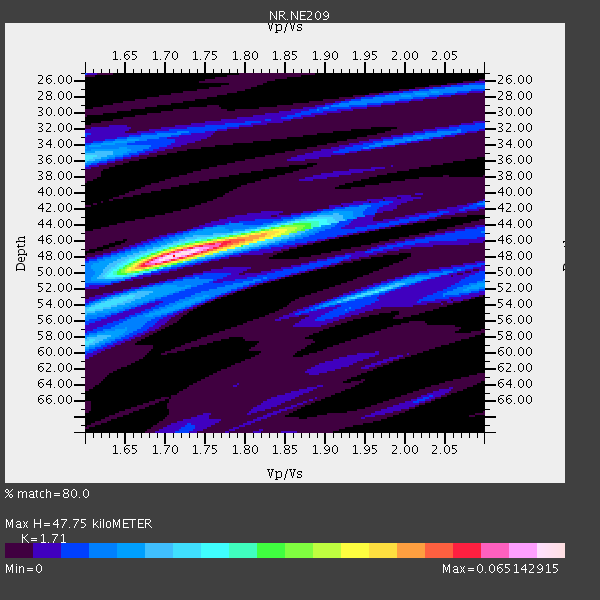
| Thickness Estimate: | 48 km |
| Thickness StdDev: | 0.8 km |
| Vp/Vs Estimate: | 1.71 |
| Vp/Vs StdDev: | 0.03 |
| Vs Estimate: | 3.759 km/s |
| Poisson's Ratio: | 0.24 |
| Peak Value: | 0.07 |
| Assumed Vp: | 6.428 km/s |
| Ps Weight: | 0.33333334 |
| PpPs Weight: | 0.33333334 |
| PsPs Weight: | 0.33333328 |
| Residual Complexity: | 0.529 |
| Nearby stations H: | +- |
| (2.0 deg) Vp/Vs: | +- |
1 with match > 90% ( 5.882353 %) and 3 with match > 80% ( 17.647058 %) out of 17.
Download stack as xyz text file.
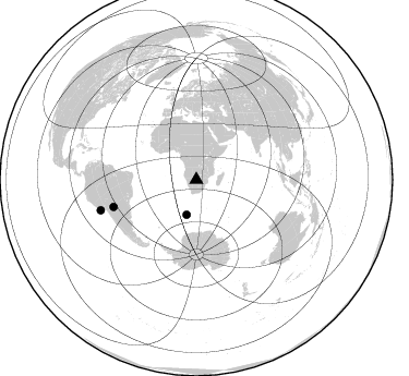
Azimuth Distribution of Events:
Prior Results for this Station
| Study | Thickness | Vp/Vs | Vp | Vs | Poissons Ratio | Extra |
| EARS | 48 km | 1.71 | 6.428 km/s | 3.759 km/s | 0.24 | |
| Crust2.0 | 41 km | 1.78 | 6.428 km/s | 3.601 km/s | 0.27 | I3,late Proter., 3.5 km seds. |
| Global Maxima | 48 km | 1.71 | 6.428 km/s | 3.759 km/s | 0.24 | amp=0.065142915 |
| Local Maxima 1 | 44 km | 1.84 | 6.428 km/s | 3.489 km/s | 0.29 | amp=0.029872254 |
| Local Maxima 2 | 52 km | 1.96 | 6.428 km/s | 3.275 km/s | 0.32 | amp=0.02306217 |
| Local Maxima 3 | 36 km | 1.60 | 6.428 km/s | 4.018 km/s | 0.18 | amp=0.021637984 |
| Local Maxima 4 | 58 km | 1.61 | 6.428 km/s | 4.005 km/s | 0.18 | amp=0.015502511 |
| Predicted Arrivals for vertical incidence (zero ray parameter) | |
| Ps | 5.27 SECOND |
| PpPs | 20.13 SECOND |
| PsPs/PpSs | 25.41 SECOND |
Events Processed for this Station
Download zip of receiver functions as SAC
Plot maxima for each earthquake.
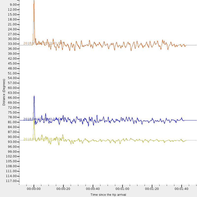
Events Used in the Stack
(3 events)| Radial Match | Distance | Baz | FERegion | Time | Lat/Lon | Depth | Magnitude |
| 95.94309 | 92.0 deg | 252.321 deg | Near Coast Of Peru | 2018/01/14 09:18:45 GMT | (-15.8, -74.7) | 36 km | 7.1 mww |
| 89.34059 | 33.4 deg | 195.475 deg | Southwest Of Africa | 2018/01/28 16:03:03 GMT | (-53.1, 9.7) | 10 km | 6.6 Mww |
| 85.40085 | 79.9 deg | 251.785 deg | Southern Bolivia | 2018/04/02 13:40:34 GMT | (-20.7, -63.0) | 562 km | 6.8 Mww |
Losers
(14 events)| Radial Match | Distance | Baz | FERegion | Time | Lat/Lon | Depth | Magnitude | Reason |
| 92.29059 | 50.3 deg | 287.272 deg | Central Mid-Atlantic Ridge | 2017/11/30 06:32:52 GMT | (-1.1, -23.5) | 10 km | 6.5 Mi | |
| 78.15083 | 83.6 deg | 239.369 deg | Near Coast Of Central Chile | 2018/04/10 10:19:34 GMT | (-31.0, -71.6) | 76 km | 6.2 Mww | |
| 73.27719 | 39.8 deg | 219.785 deg | Southern Mid-Atlantic Ridge | 2018/03/17 05:50:09 GMT | (-47.7, -13.5) | 10 km | 5.5 mb | |
| 65.495476 | 78.2 deg | 245.763 deg | Santiago Del Estero Prov., Arg. | 2018/03/25 14:28:34 GMT | (-26.8, -63.4) | 567 km | 5.6 Mww | |
| 62.97694 | 73.4 deg | 38.095 deg | Afghanistan-Tajikistan Bord Reg. | 2018/05/09 10:41:45 GMT | (37.0, 71.4) | 112 km | 6.2 Mww | |
| 60.47823 | 50.4 deg | 213.205 deg | South Sandwich Islands Region | 2018/03/16 09:25:01 GMT | (-56.5, -25.7) | 10 km | 5.6 mb | |
| 57.577286 | 72.8 deg | 38.105 deg | Hindu Kush Region, Afghanistan | 2018/01/31 07:07:00 GMT | (36.5, 70.8) | 191 km | 6.1 Mww | |
| 55.32785 | 80.1 deg | 93.886 deg | Java, Indonesia | 2018/01/23 06:34:54 GMT | (-7.2, 105.9) | 44 km | 6.0 Mww | |
| 55.058754 | 82.9 deg | 60.102 deg | Myanmar-India Border Region | 2018/01/07 06:47:14 GMT | (24.8, 94.9) | 23 km | 5.5 Mww | |
| 54.758102 | 91.8 deg | 252.301 deg | Near Coast Of Peru | 2018/01/30 14:23:49 GMT | (-15.9, -74.6) | 10 km | 5.3 Mww | |
| 53.292873 | 61.0 deg | 32.917 deg | Northern And Central Iran | 2017/12/12 08:43:17 GMT | (30.7, 57.3) | 10 km | 6.0 Mww | |
| 50.7386 | 75.2 deg | 86.227 deg | Southern Sumatra, Indonesia | 2018/06/13 06:59:01 GMT | (-1.9, 98.7) | 10 km | 5.4 Mww | |
| 49.991585 | 86.6 deg | 249.56 deg | Near Coast Of Northern Chile | 2018/04/05 11:12:10 GMT | (-20.4, -70.6) | 35 km | 5.6 Mww | |
| 34.420994 | 88.6 deg | 225.672 deg | West Chile Rise | 2017/11/10 12:01:34 GMT | (-41.5, -84.1) | 10 km | 5.8 Mww |

