
Station NR NE214 - Gumare
Network: NR - NARS Array
Nearby stations (2 deg radius)
| Station | Name | (Lat, Lon) | Start / End | Elevation |
| NE214 | Gumare | (-19.39, 22.16) | 2015-11-22 / 2599-12-31 | 985 m |
| Crust2 Type: | H4,early/mid Proter. shield, Africa, 1.5 km seds. |
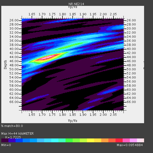
| Thickness Estimate: | 44 km |
| Thickness StdDev: | 2.2 km |
| Vp/Vs Estimate: | 1.72 |
| Vp/Vs StdDev: | 0.04 |
| Vs Estimate: | 3.783 km/s |
| Poisson's Ratio: | 0.25 |
| Peak Value: | 0.10 |
| Assumed Vp: | 6.516 km/s |
| Ps Weight: | 0.33333334 |
| PpPs Weight: | 0.33333334 |
| PsPs Weight: | 0.33333328 |
| Residual Complexity: | 0.525 |
| Nearby stations H: | +- |
| (2.0 deg) Vp/Vs: | +- |
4 with match > 90% ( 13.793103 %) and 6 with match > 80% ( 20.689655 %) out of 29.
Download stack as xyz text file.
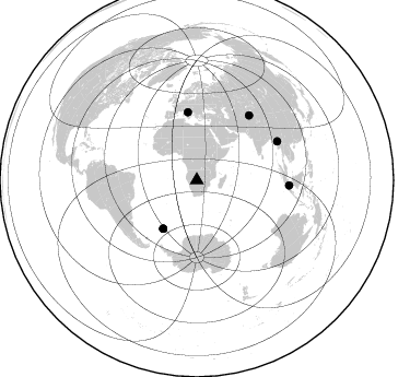
Azimuth Distribution of Events:
Prior Results for this Station
| Study | Thickness | Vp/Vs | Vp | Vs | Poissons Ratio | Extra |
| EARS | 44 km | 1.72 | 6.516 km/s | 3.783 km/s | 0.25 | |
| Crust2.0 | 46 km | 1.78 | 6.516 km/s | 3.661 km/s | 0.27 | H4,early/mid Proter. shield, Africa, 1.5 km seds. |
| Global Maxima | 44 km | 1.72 | 6.516 km/s | 3.783 km/s | 0.25 | amp=0.0954884 |
| Local Maxima 1 | 38 km | 1.85 | 6.516 km/s | 3.517 km/s | 0.29 | amp=0.040105484 |
| Local Maxima 2 | 46 km | 1.71 | 6.516 km/s | 3.816 km/s | 0.24 | amp=0.02896301 |
| Local Maxima 3 | 38 km | 2.10 | 6.516 km/s | 3.107 km/s | 0.35 | amp=0.027715923 |
| Local Maxima 4 | 34 km | 1.91 | 6.516 km/s | 3.416 km/s | 0.31 | amp=0.027555704 |
| Predicted Arrivals for vertical incidence (zero ray parameter) | |
| Ps | 4.88 SECOND |
| PpPs | 18.38 SECOND |
| PsPs/PpSs | 23.26 SECOND |
Events Processed for this Station
Download zip of receiver functions as SAC
Plot maxima for each earthquake.
Events Used in the Stack
(6 events)| Radial Match | Distance | Baz | FERegion | Time | Lat/Lon | Depth | Magnitude |
| 92.32685 | 54.1 deg | 214.866 deg | South Georgia Island Region | 2016/08/19 07:32:22 GMT | (-55.3, -31.9) | 10 km | 7.4 MO |
| 91.18496 | 81.4 deg | 64.333 deg | Myanmar | 2016/08/24 10:34:55 GMT | (20.9, 94.6) | 84 km | 6.8 MO |
| 90.412544 | 53.9 deg | 214.896 deg | South Georgia Island Region | 2016/08/21 03:45:23 GMT | (-55.3, -31.8) | 10 km | 6.4 MWP |
| 90.22673 | 62.5 deg | 352.487 deg | Central Italy | 2016/10/30 06:40:19 GMT | (42.9, 13.1) | 10 km | 6.6 MWW, 6.6 MWR |
| 86.78449 | 84.6 deg | 93.256 deg | Java Sea | 2016/10/19 00:26:01 GMT | (-4.9, 108.2) | 614 km | 6.6 MWW, 6.6 MWC, 6.7 MWB |
| 85.71362 | 75.8 deg | 39.061 deg | Southern Xinjiang, China | 2016/11/25 14:24:29 GMT | (39.2, 74.0) | 13 km | 6.6 MWW, 6.5 MWB, 6.6 MWC |
Losers
(23 events)| Radial Match | Distance | Baz | FERegion | Time | Lat/Lon | Depth | Magnitude | Reason |
| 97.317856 | 81.6 deg | 227.134 deg | Southern Chile | 2016/12/25 14:22:28 GMT | (-43.3, -74.5) | 15 km | 7.7 Mi | |
| 78.26273 | 89.7 deg | 259.623 deg | Peru-Brazil Border Region | 2016/12/18 13:30:11 GMT | (-10.0, -71.0) | 619 km | 6.4 Mww | |
| 75.0118 | 52.1 deg | 212.656 deg | South Sandwich Islands Region | 2016/07/31 11:33:20 GMT | (-56.3, -27.5) | 98 km | 5.9 MWW, 5.9 MWC, 5.9 MWB | |
| 74.84802 | 93.0 deg | 100.64 deg | Sumbawa Region, Indonesia | 2016/12/29 22:30:18 GMT | (-9.1, 118.6) | 72 km | 6.2 Mwp | |
| 73.4659 | 80.8 deg | 239.748 deg | San Juan Province, Argentina | 2016/11/20 20:57:43 GMT | (-31.6, -68.8) | 116 km | 6.4 MWP, 6.5 MWB | |
| 72.15649 | 84.3 deg | 140.499 deg | Western Indian-Antarctic Ridge | 2016/07/25 09:00:28 GMT | (-49.4, 126.4) | 10 km | 5.5 MB | |
| 71.762215 | 83.2 deg | 233.76 deg | Near Coast Of Central Chile | 2016/11/08 04:55:44 GMT | (-36.6, -73.6) | 17 km | 5.9 MO | |
| 69.913376 | 83.4 deg | 238.989 deg | Near Coast Of Central Chile | 2016/12/08 20:42:37 GMT | (-31.6, -71.9) | 30 km | 5.2 Mwr | |
| 69.72071 | 55.8 deg | 106.228 deg | South Indian Ocean | 2016/08/05 12:34:15 GMT | (-23.9, 82.4) | 10 km | 5.7 MB | |
| 68.25128 | 62.3 deg | 352.529 deg | Central Italy | 2016/08/24 01:36:33 GMT | (42.7, 13.2) | 10 km | 6.2 MWP | |
| 67.87687 | 62.5 deg | 352.511 deg | Central Italy | 2016/08/24 02:33:30 GMT | (42.8, 13.1) | 10 km | 5.5 MB | |
| 67.62876 | 62.6 deg | 352.465 deg | Central Italy | 2016/10/26 19:18:08 GMT | (42.9, 13.0) | 10 km | 6.1 MWW, 6.0 MWB, 6.1 MWR | |
| 65.95976 | 84.1 deg | 244.536 deg | Near Coast Of Northern Chile | 2016/07/25 17:26:49 GMT | (-26.1, -70.6) | 68 km | 6.2 MB | |
| 63.435463 | 54.1 deg | 215.061 deg | South Georgia Island Region | 2016/08/19 20:37:16 GMT | (-55.2, -32.1) | 8.6 km | 5.6 MB | |
| 62.640427 | 53.4 deg | 208.966 deg | South Sandwich Islands Region | 2016/09/22 16:07:27 GMT | (-59.5, -27.4) | 10 km | 5.6 MB | |
| 58.411877 | 58.9 deg | 352.194 deg | Tyrrhenian Sea | 2016/10/28 20:02:48 GMT | (39.3, 13.5) | 448 km | 5.8 MWW, 5.8 MWB | |
| 57.724354 | 87.8 deg | 254.654 deg | Southern Peru | 2016/12/01 22:40:26 GMT | (-15.3, -70.8) | 10 km | 6.3 Mww | |
| 54.91979 | 96.7 deg | 261.702 deg | Northern Peru | 2016/09/10 10:08:20 GMT | (-5.6, -77.0) | 114 km | 6.0 MB | |
| 51.94598 | 53.2 deg | 214.532 deg | South Sandwich Islands Region | 2016/08/30 15:46:02 GMT | (-55.3, -30.4) | 10 km | 5.6 MB | |
| 51.080605 | 89.2 deg | 286.348 deg | Leeward Islands | 2016/10/18 22:08:14 GMT | (15.2, -61.5) | 143 km | 5.6 MWW, 5.6 MWB | |
| 50.97473 | 86.0 deg | 40.77 deg | Northern Xinjiang, China | 2016/12/08 05:15:04 GMT | (43.8, 86.3) | 14 km | 5.9 Mwp | |
| 50.271885 | 88.1 deg | 330.031 deg | Reykjanes Ridge | 2016/06/25 17:54:19 GMT | (53.9, -35.4) | 10 km | 5.5 MWC, 5.5 MWC | |
| 49.20273 | 64.9 deg | 3.436 deg | Romania | 2016/12/27 23:20:55 GMT | (45.7, 26.6) | 81 km | 5.6 mb |

