
Station NR NE215 - Bottlepan
Network: NR - NARS Array
Nearby stations (2 deg radius)
| Station | Name | (Lat, Lon) | Start / End | Elevation |
| NE215 | Bottlepan | (-18.78, 25.20) | 2015-11-19 / 2599-12-31 | 1035 m |
| NE215 | Bottlepan | (-18.78, 25.20) | 2015-11-20 / 2599-12-31 | 1035 m |
| Crust2 Type: | I7,late Proter., 1 km seds. |
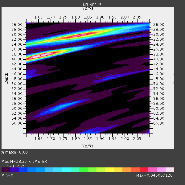
| Thickness Estimate: | 38 km |
| Thickness StdDev: | 3.0 km |
| Vp/Vs Estimate: | 1.66 |
| Vp/Vs StdDev: | 0.07 |
| Vs Estimate: | 3.989 km/s |
| Poisson's Ratio: | 0.21 |
| Peak Value: | 0.05 |
| Assumed Vp: | 6.612 km/s |
| Ps Weight: | 0.33333334 |
| PpPs Weight: | 0.33333334 |
| PsPs Weight: | 0.33333328 |
| Residual Complexity: | 0.758 |
| Nearby stations H: | +- |
| (2.0 deg) Vp/Vs: | +- |
3 with match > 90% ( 15.789474 %) and 5 with match > 80% ( 26.31579 %) out of 19.
Download stack as xyz text file.
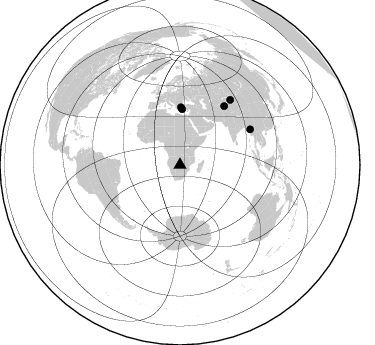
Azimuth Distribution of Events:
Prior Results for this Station
| Study | Thickness | Vp/Vs | Vp | Vs | Poissons Ratio | Extra |
| EARS | 38 km | 1.66 | 6.612 km/s | 3.989 km/s | 0.21 | |
| Crust2.0 | 42 km | 1.78 | 6.612 km/s | 3.71 km/s | 0.27 | I7,late Proter., 1 km seds. |
| Global Maxima | 38 km | 1.66 | 6.612 km/s | 3.989 km/s | 0.21 | amp=0.046067126 |
| Local Maxima 1 | 30 km | 1.82 | 6.612 km/s | 3.638 km/s | 0.28 | amp=0.039583746 |
| Local Maxima 2 | 34 km | 1.60 | 6.612 km/s | 4.126 km/s | 0.18 | amp=0.017690208 |
| Local Maxima 3 | 59 km | 1.75 | 6.612 km/s | 3.789 km/s | 0.26 | amp=0.0118660955 |
| Local Maxima 4 | 28 km | 1.94 | 6.612 km/s | 3.404 km/s | 0.32 | amp=0.011659402 |
| Predicted Arrivals for vertical incidence (zero ray parameter) | |
| Ps | 3.80 SECOND |
| PpPs | 15.37 SECOND |
| PsPs/PpSs | 19.18 SECOND |
Events Processed for this Station
Download zip of receiver functions as SAC
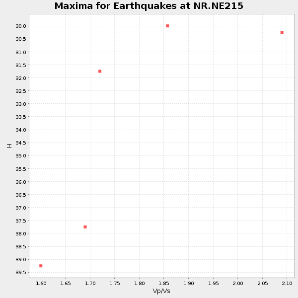
Plot maxima for each earthquake.
Events Used in the Stack
(5 events)| Radial Match | Distance | Baz | FERegion | Time | Lat/Lon | Depth | Magnitude |
| 93.75234 | 55.5 deg | 2.199 deg | Dodecanese Islands, Greece | 2017/07/20 22:31:12 GMT | (36.9, 27.5) | 10 km | 6.7 Mww |
| 93.51758 | 78.6 deg | 63.218 deg | Myanmar | 2016/08/24 10:34:55 GMT | (20.9, 94.6) | 84 km | 6.8 MO |
| 93.12142 | 73.3 deg | 36.977 deg | Tajikistan-Xinjiang Border Reg. | 2016/06/26 11:17:11 GMT | (39.5, 73.3) | 16 km | 6.4 MWW, 6.3 MWB |
| 89.248024 | 81.9 deg | 37.778 deg | Northern Xinjiang, China | 2017/08/08 23:27:53 GMT | (44.3, 82.8) | 20 km | 6.3 Mww |
| 87.83189 | 57.4 deg | 1.081 deg | Aegean Sea | 2017/06/12 12:28:38 GMT | (38.9, 26.4) | 10 km | 6.3 Mww |
Losers
(14 events)| Radial Match | Distance | Baz | FERegion | Time | Lat/Lon | Depth | Magnitude | Reason |
| 79.78041 | 39.1 deg | 94.76 deg | Mauritius - Reunion Region | 2017/07/19 12:16:25 GMT | (-17.4, 66.4) | 10 km | 5.9 Mww | |
| 75.42313 | 54.2 deg | 213.231 deg | South Sandwich Islands Region | 2016/07/31 11:33:20 GMT | (-56.3, -27.5) | 98 km | 5.9 MWW, 5.9 MWC, 5.9 MWB | |
| 67.300156 | 56.2 deg | 215.453 deg | South Georgia Island Region | 2016/08/19 17:33:40 GMT | (-55.2, -32.1) | 4.3 km | 5.8 MWW, 5.7 MWB, 5.8 MWC | |
| 66.19216 | 53.3 deg | 106.224 deg | South Indian Ocean | 2016/08/05 12:34:15 GMT | (-23.9, 82.4) | 10 km | 5.7 MB | |
| 64.24227 | 80.1 deg | 287.777 deg | North Atlantic Ocean | 2017/07/27 17:53:25 GMT | (13.4, -49.4) | 10 km | 5.9 Mww | |
| 63.99275 | 91.0 deg | 55.287 deg | Gansu, China | 2017/08/08 13:19:49 GMT | (33.2, 103.8) | 10 km | 6.5 Mww | |
| 63.81262 | 53.3 deg | 106.25 deg | South Indian Ocean | 2016/08/01 07:42:51 GMT | (-24.0, 82.5) | 10 km | 6.1 MB | |
| 63.528557 | 62.2 deg | 350.003 deg | Central Italy | 2016/08/24 01:36:33 GMT | (42.7, 13.2) | 10 km | 6.2 MWP | |
| 62.33001 | 90.2 deg | 331.996 deg | Reykjanes Ridge | 2017/09/01 11:07:37 GMT | (57.0, -34.0) | 10 km | 5.7 Mww | |
| 60.039974 | 54.4 deg | 210.146 deg | South Sandwich Islands Region | 2017/05/30 11:29:51 GMT | (-58.6, -26.1) | 78 km | 5.7 Mww | |
| 60.024586 | 86.0 deg | 233.947 deg | Off Coast Of Central Chile | 2017/07/04 16:05:58 GMT | (-35.5, -73.4) | 10 km | 5.9 Mww | |
| 57.27887 | 86.9 deg | 243.605 deg | Near Coast Of Northern Chile | 2016/07/25 17:26:49 GMT | (-26.1, -70.6) | 68 km | 6.2 MB | |
| 50.099396 | 84.1 deg | 248.479 deg | Jujuy Province, Argentina | 2016/08/04 14:15:11 GMT | (-22.4, -66.0) | 258 km | 6.0 MO | |
| 46.76515 | 89.9 deg | 98.569 deg | Sumbawa Region, Indonesia | 2016/07/31 23:40:00 GMT | (-8.2, 117.8) | 10 km | 5.8 MB |

