
Station NR NE220 - Lephepe
Network: NR - NARS Array
Nearby stations (2 deg radius)
| Station | Name | (Lat, Lon) | Start / End | Elevation |
| NE220 | Lephepe | (-23.36, 25.86) | 2013-02-22 / 2599-12-31 | 1020 m |
| Crust2 Type: | G1,Archean, no seds. |
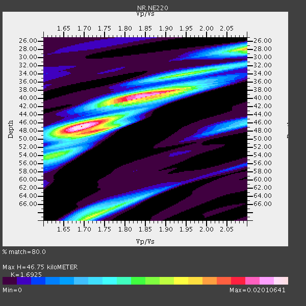
| Thickness Estimate: | 47 km |
| Thickness StdDev: | 7.3 km |
| Vp/Vs Estimate: | 1.69 |
| Vp/Vs StdDev: | 0.09 |
| Vs Estimate: | 3.817 km/s |
| Poisson's Ratio: | 0.23 |
| Peak Value: | 0.02 |
| Assumed Vp: | 6.459 km/s |
| Ps Weight: | 0.33333334 |
| PpPs Weight: | 0.33333334 |
| PsPs Weight: | 0.33333328 |
| Residual Complexity: | 0.756 |
| Nearby stations H: | +- |
| (2.0 deg) Vp/Vs: | +- |
3 with match > 90% ( 8.571428 %) and 7 with match > 80% ( 20.0 %) out of 35.
Download stack as xyz text file.
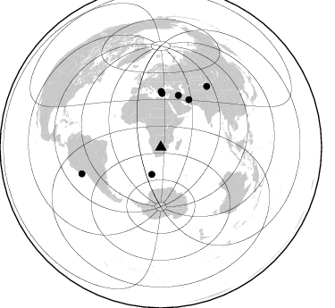
Azimuth Distribution of Events:
Prior Results for this Station
| Study | Thickness | Vp/Vs | Vp | Vs | Poissons Ratio | Extra |
| EARS | 47 km | 1.69 | 6.459 km/s | 3.817 km/s | 0.23 | |
| Crust2.0 | 37 km | 1.76 | 6.459 km/s | 3.665 km/s | 0.26 | G1,Archean, no seds. |
| Global Maxima | 47 km | 1.69 | 6.459 km/s | 3.817 km/s | 0.23 | amp=0.02010641 |
| Local Maxima 1 | 39 km | 1.87 | 6.459 km/s | 3.454 km/s | 0.30 | amp=0.01777274 |
| Local Maxima 2 | 28 km | 2.10 | 6.459 km/s | 3.08 km/s | 0.35 | amp=0.014423411 |
| Local Maxima 3 | 69 km | 1.72 | 6.459 km/s | 3.761 km/s | 0.24 | amp=0.012369297 |
| Local Maxima 4 | 48 km | 1.75 | 6.459 km/s | 3.702 km/s | 0.26 | amp=0.010606667 |
| Predicted Arrivals for vertical incidence (zero ray parameter) | |
| Ps | 5.01 SECOND |
| PpPs | 19.49 SECOND |
| PsPs/PpSs | 24.50 SECOND |
Events Processed for this Station
Download zip of receiver functions as SAC
Plot maxima for each earthquake.
Events Used in the Stack
(7 events)| Radial Match | Distance | Baz | FERegion | Time | Lat/Lon | Depth | Magnitude |
| 99.24846 | 61.0 deg | 18.837 deg | Iran-Iraq Border Region | 2017/11/12 18:18:17 GMT | (34.9, 46.0) | 19 km | 7.3 Mww |
| 95.34331 | 60.0 deg | 1.478 deg | Dodecanese Islands, Greece | 2017/07/20 22:31:12 GMT | (36.9, 27.5) | 10 km | 6.7 Mww |
| 92.51291 | 32.1 deg | 198.443 deg | Southwest Of Africa | 2018/01/28 16:03:03 GMT | (-53.1, 9.7) | 10 km | 6.6 Mww |
| 89.152245 | 93.2 deg | 251.418 deg | Near Coast Of Peru | 2018/01/14 09:18:45 GMT | (-15.8, -74.7) | 36 km | 7.1 mww |
| 85.269035 | 61.7 deg | 30.687 deg | Northern And Central Iran | 2017/12/01 02:32:46 GMT | (30.7, 57.3) | 9.0 km | 6.1 Mww |
| 81.66499 | 62.0 deg | 0.445 deg | Aegean Sea | 2017/06/12 12:28:38 GMT | (38.9, 26.4) | 10 km | 6.3 Mww |
| 80.40376 | 85.1 deg | 37.169 deg | Northern Xinjiang, China | 2017/08/08 23:27:53 GMT | (44.3, 82.8) | 20 km | 6.3 Mww |
Losers
(28 events)| Radial Match | Distance | Baz | FERegion | Time | Lat/Lon | Depth | Magnitude | Reason |
| 91.618904 | 52.7 deg | 287.503 deg | Central Mid-Atlantic Ridge | 2017/11/30 06:32:52 GMT | (-1.1, -23.5) | 10 km | 6.5 Mi | |
| 81.85525 | 79.8 deg | 94.054 deg | Java, Indonesia | 2017/12/15 16:47:56 GMT | (-7.7, 108.0) | 92 km | 6.5 Mww | |
| 71.297585 | 59.9 deg | 19.126 deg | Iran-Iraq Border Region | 2018/01/11 06:59:31 GMT | (33.8, 45.7) | 10 km | 5.5 Mww | |
| 69.87815 | 93.6 deg | 56.429 deg | Sichuan, China | 2017/09/30 06:14:36 GMT | (32.3, 105.0) | 10 km | 5.5 mb | |
| 67.88092 | 82.1 deg | 288.188 deg | North Atlantic Ocean | 2017/07/27 17:53:25 GMT | (13.4, -49.4) | 10 km | 5.9 Mww | |
| 67.468895 | 82.9 deg | 242.084 deg | La Rioja Province, Argentina | 2017/08/01 06:13:53 GMT | (-28.6, -68.7) | 85 km | 5.6 Mww | |
| 66.47398 | 87.7 deg | 250.956 deg | Northern Chile | 2017/10/10 06:32:20 GMT | (-18.5, -69.6) | 82 km | 6.3 Mww | |
| 63.500893 | 73.1 deg | 36.48 deg | Hindu Kush Region, Afghanistan | 2018/01/31 07:07:00 GMT | (36.5, 70.8) | 191 km | 6.1 Mww | |
| 59.700283 | 79.5 deg | 240.808 deg | Cordoba Province, Argentina | 2017/10/12 18:59:08 GMT | (-31.0, -65.6) | 157 km | 5.5 Mww | |
| 58.937378 | 94.4 deg | 331.872 deg | Reykjanes Ridge | 2017/09/10 21:40:21 GMT | (57.1, -33.7) | 10 km | 5.9 Mww | |
| 56.95596 | 92.6 deg | 285.2 deg | Leeward Islands | 2017/02/03 19:54:21 GMT | (15.1, -60.5) | 35 km | 5.6 Mwb | |
| 56.738316 | 50.8 deg | 212.117 deg | South Sandwich Islands Region | 2017/05/30 11:29:51 GMT | (-58.6, -26.1) | 78 km | 5.7 Mww | |
| 56.228973 | 87.5 deg | 250.631 deg | Northern Chile | 2018/01/21 01:06:42 GMT | (-18.9, -69.6) | 111 km | 6.3 Mww | |
| 54.066353 | 61.7 deg | 30.615 deg | Northern And Central Iran | 2017/12/12 21:41:31 GMT | (30.8, 57.3) | 8.0 km | 6.0 Mww | |
| 53.402935 | 81.8 deg | 232.974 deg | S. Chile-Argentina Border Region | 2017/05/29 14:57:54 GMT | (-37.3, -71.6) | 87 km | 5.7 Mwr | |
| 50.00694 | 76.4 deg | 41.101 deg | Eastern Kashmir | 2017/12/06 23:29:02 GMT | (35.7, 77.6) | 59 km | 5.1 Mww | |
| 49.452183 | 77.1 deg | 91.597 deg | Sunda Strait, Indonesia | 2017/11/08 19:17:07 GMT | (-6.5, 104.6) | 39 km | 5.1 Mww | |
| 48.721695 | 75.4 deg | 87.838 deg | Southern Sumatra, Indonesia | 2017/08/13 03:08:11 GMT | (-3.8, 101.6) | 36 km | 6.4 Mww | |
| 47.052933 | 32.1 deg | 108.112 deg | Southwest Indian Ridge | 2017/01/29 16:42:26 GMT | (-29.2, 61.1) | 10 km | 5.8 mb | |
| 46.91599 | 82.3 deg | 58.966 deg | Myanmar-India Border Region | 2018/01/07 06:47:14 GMT | (24.8, 94.9) | 23 km | 5.5 Mww | |
| 46.05541 | 48.8 deg | 125.034 deg | Mid-Indian Ridge | 2017/06/24 07:27:07 GMT | (-41.2, 80.6) | 10 km | 5.5 Mwb | |
| 45.739098 | 93.7 deg | 99.453 deg | Banda Sea | 2017/10/24 10:47:47 GMT | (-7.2, 123.0) | 549 km | 6.7 Mww | |
| 44.388176 | 97.5 deg | 201.331 deg | Southern East Pacific Rise | 2017/12/29 21:20:53 GMT | (-53.1, -117.4) | 10 km | 5.7 Mww | |
| 43.760128 | 93.7 deg | 92.981 deg | Sulawesi, Indonesia | 2017/05/29 14:35:20 GMT | (-1.3, 120.5) | 9.4 km | 6.6 Mww | |
| 42.34091 | 85.6 deg | 244.936 deg | Near Coast Of Northern Chile | 2017/12/28 03:54:52 GMT | (-24.9, -70.2) | 53 km | 5.5 Mww | |
| 40.947826 | 66.4 deg | 17.791 deg | Eastern Caucasus | 2017/11/15 19:48:03 GMT | (40.3, 47.3) | 23 km | 5.2 Mww | |
| 36.21376 | 61.6 deg | 30.666 deg | Northern And Central Iran | 2017/12/12 08:43:17 GMT | (30.7, 57.3) | 10 km | 6.0 Mww | |
| 26.380903 | 96.9 deg | 93.659 deg | Minahassa Peninsula, Sulawesi | 2017/12/06 16:06:55 GMT | (-0.6, 123.7) | 18 km | 5.6 mb |

