
Station NR NE70 - Mexicali, Mexico
Network: NR - NARS Array
Nearby stations (2 deg radius)
| Station | Name | (Lat, Lon) | Start / End | Elevation |
| NE70 | Mexicali, Mexico | (32.42, -115.26) | 2002-04-01 / 2499-01-01 | -23.0 m |
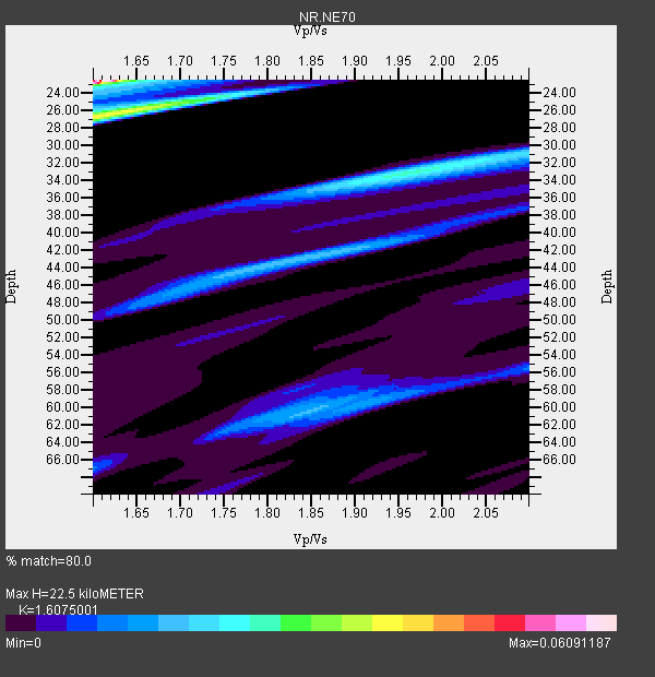
| Crust2 Type: | ME,very thin extended crust, 1.5 km seds. |
| Thickness Estimate: | 22 km |
| Thickness StdDev: | 6.6 km |
| Vp/Vs Estimate: | 1.61 |
| Vp/Vs StdDev: | 0.08 |
| Vs Estimate: | 3.829 km/s |
| Poisson's Ratio: | 0.18 |
| Peak Value: | 0.06 |
| Assumed Vp: | 6.155 km/s |
| Ps Weight: | 0.33333334 |
| PpPs Weight: | 0.33333334 |
| PsPs Weight: | 0.33333328 |
| Residual Complexity: | 0.905 |
| Nearby stations H: | +- |
| (2.0 deg) Vp/Vs: | +- |
2 with match > 90% ( 33.333332 %) and 5 with match > 80% ( 83.333336 %) out of 6.
Download stack as xyz text file.
Azimuth Distribution of Events:

Prior Results for this Station
| Study | Thickness | Vp/Vs | Vp | Vs | Poissons Ratio | Extra |
| EARS | 22 km | 1.61 | 6.155 km/s | 3.829 km/s | 0.18 | |
| Crust2.0 | 28 km | 1.78 | 6.155 km/s | 3.46 km/s | 0.27 | ME,very thin extended crust, 1.5 km seds. |
| Global Maxima | 22 km | 1.61 | 6.155 km/s | 3.829 km/s | 0.18 | amp=0.06091187 |
| Local Maxima 1 | 26 km | 1.61 | 6.155 km/s | 3.823 km/s | 0.19 | amp=0.03798817 |
| Local Maxima 2 | 33 km | 1.96 | 6.155 km/s | 3.136 km/s | 0.32 | amp=0.02513092 |
| Local Maxima 3 | 44 km | 1.81 | 6.155 km/s | 3.41 km/s | 0.28 | amp=0.017623056 |
| Local Maxima 4 | 60 km | 1.85 | 6.155 km/s | 3.331 km/s | 0.29 | amp=0.016262375 |
| Predicted Arrivals for vertical incidence (zero ray parameter) | |
| Ps | 2.22 SECOND |
| PpPs | 9.53 SECOND |
| PsPs/PpSs | 11.75 SECOND |
Events Processed for this Station
Download zip of receiver functions as SAC
Plot maxima for each earthquake.
Events Used in the Stack
(5 events)| Radial Match | Distance | Baz | FERegion | Time | Lat/Lon | Depth | Magnitude |
| 90.98747 | 52.9 deg | 128.494 deg | Northern Peru | 2005/09/26 01:55:37 GMT | (-5.7, -76.4) | 115 km | 6.7 MB, 7.5 MW, 7.5 MW |
| 90.98174 | 85.7 deg | 306.744 deg | Near S. Coast Of Honshu, Japan | 2004/09/05 14:57:18 GMT | (33.2, 137.1) | 10 km | 6.2 MB, 7.1 MS, 7.4 MW, 7.4 MW |
| 87.80378 | 86.0 deg | 306.877 deg | Near S. Coast Of Western Honshu | 2004/09/05 10:07:07 GMT | (33.1, 136.6) | 14 km | 6.7 MB, 7.0 MS, 7.2 MW, 7.0 MW |
| 83.39986 | 34.1 deg | 121.613 deg | Near Coast Of Nicaragua | 2005/07/02 02:16:43 GMT | (11.2, -86.2) | 27 km | 5.6 MB, 6.4 MS, 6.6 MW, 6.6 MW |
| 82.78593 | 33.6 deg | 121.972 deg | Near Coast Of Nicaragua | 2004/10/09 21:26:53 GMT | (11.4, -86.7) | 35 km | 6.0 MB, 7.0 MS, 6.9 MW, 6.8 MW |
Losers
(1 events)| Radial Match | Distance | Baz | FERegion | Time | Lat/Lon | Depth | Magnitude | Reason |
| 61.86637 | 33.9 deg | 121.496 deg | Near Coast Of Nicaragua | 2005/07/02 04:11:04 GMT | (11.4, -86.3) | 40 km | 5.4 MB, 5.4 MS, 5.8 MW, 5.0 MD |
