
Station OK KAY1 - Blackwell Oklahoma
Network: OK - Oklahoma Seismic Network
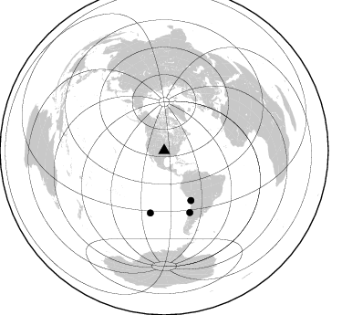
Nearby stations (2 deg radius)
| Station | Name | (Lat, Lon) | Start / End | Elevation |
| KAY1 | Blackwell Oklahoma | (36.76, -97.21) | 2014-03-26 / 2599-12-31 | 308 m |
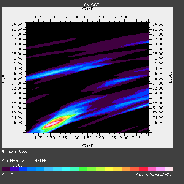
| Crust2 Type: | D5,thick Platform 2 km seds. |
| Thickness Estimate: | 66 km |
| Thickness StdDev: | 3.7 km |
| Vp/Vs Estimate: | 1.71 |
| Vp/Vs StdDev: | 0.08 |
| Vs Estimate: | 3.802 km/s |
| Poisson's Ratio: | 0.24 |
| Peak Value: | 0.02 |
| Assumed Vp: | 6.483 km/s |
| Ps Weight: | 0.33333334 |
| PpPs Weight: | 0.33333334 |
| PsPs Weight: | 0.33333328 |
| Residual Complexity: | 0.536 |
| Nearby stations H: | +- |
| (2.0 deg) Vp/Vs: | +- |
1 with match > 90% ( 3.5714285 %) and 3 with match > 80% ( 10.714286 %) out of 28.
Download stack as xyz text file.
Azimuth Distribution of Events:
Prior Results for this Station
| Study | Thickness | Vp/Vs | Vp | Vs | Poissons Ratio | Extra |
| EARS | 66 km | 1.71 | 6.483 km/s | 3.802 km/s | 0.24 | |
| Crust2.0 | 46 km | 1.78 | 6.483 km/s | 3.648 km/s | 0.27 | D5,thick Platform 2 km seds. |
| Global Maxima | 66 km | 1.71 | 6.483 km/s | 3.802 km/s | 0.24 | amp=0.024313498 |
| Local Maxima 1 | 64 km | 1.75 | 6.483 km/s | 3.715 km/s | 0.26 | amp=0.015120657 |
| Local Maxima 2 | 45 km | 1.72 | 6.483 km/s | 3.774 km/s | 0.24 | amp=0.008147588 |
| Local Maxima 3 | 68 km | 1.71 | 6.483 km/s | 3.785 km/s | 0.24 | amp=0.005795588 |
| Local Maxima 4 | 59 km | 2.08 | 6.483 km/s | 3.124 km/s | 0.35 | amp=0.0045543485 |
| Predicted Arrivals for vertical incidence (zero ray parameter) | |
| Ps | 7.20 SECOND |
| PpPs | 27.64 SECOND |
| PsPs/PpSs | 34.85 SECOND |
Events Processed for this Station
Download zip of receiver functions as SAC
Plot maxima for each earthquake.
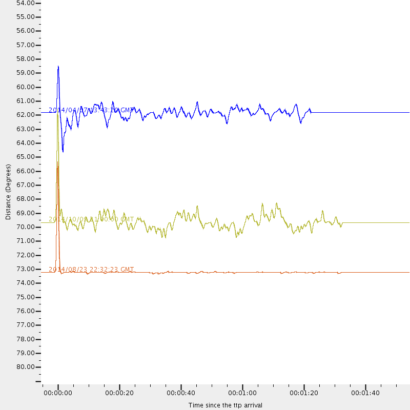
Events Used in the Stack
(3 events)| Radial Match | Distance | Baz | FERegion | Time | Lat/Lon | Depth | Magnitude |
| 99.616806 | 73.2 deg | 157.439 deg | Near Coast Of Central Chile | 2014/08/23 22:32:23 GMT | (-32.7, -71.4) | 32 km | 6.4 MWW, 6.6 MWP |
| 85.212265 | 69.6 deg | 192.6 deg | Easter Island Region | 2014/10/09 21:00:00 GMT | (-32.0, -111.1) | 10 km | 5.7 MWW, 5.6 MWC |
| 82.83673 | 61.8 deg | 151.777 deg | Near Coast Of Northern Chile | 2014/04/07 13:43:20 GMT | (-20.2, -70.9) | 7.9 km | 5.8 MWB, 5.7 MWW, 5.7 MWC |
Losers
(25 events)| Radial Match | Distance | Baz | FERegion | Time | Lat/Lon | Depth | Magnitude | Reason |
| 99.973495 | 55.7 deg | 151.985 deg | Central Peru | 2014/08/24 23:21:45 GMT | (-14.6, -73.6) | 101 km | 6.9 MWW, 6.8 MI, 6.9 MWB | |
| 94.71059 | 61.9 deg | 150.365 deg | Northern Chile | 2014/10/07 05:09:10 GMT | (-19.7, -69.7) | 103 km | 5.8 MB | |
| 78.40954 | 36.1 deg | 324.76 deg | Southeastern Alaska | 2014/07/17 11:49:32 GMT | (60.4, -140.3) | 0.6 km | 5.8 MI | |
| 74.02578 | 92.7 deg | 246.174 deg | Tonga Islands | 2014/04/26 06:02:16 GMT | (-20.7, -174.7) | 10 km | 6.5 MWP | |
| 73.16159 | 93.7 deg | 249.99 deg | Fiji Islands Region | 2014/05/09 14:03:59 GMT | (-18.4, -178.1) | 528 km | 5.6 MB | |
| 70.50643 | 52.8 deg | 311.673 deg | Fox Islands, Aleutian Islands | 2014/06/20 12:16:46 GMT | (51.9, -171.4) | 26 km | 5.6 MB, 5.0 ML, 5.1 ML, 5.3 MWB | |
| 69.55486 | 33.8 deg | 322.538 deg | Southeastern Alaska | 2014/07/25 10:54:49 GMT | (58.4, -137.1) | 10 km | 5.9 MWP | |
| 67.40355 | 62.3 deg | 151.864 deg | Near Coast Of Northern Chile | 2014/04/04 01:37:51 GMT | (-20.6, -70.7) | 20 km | 6.1 MWP, 6.1 MWB, 6.1 MWW, 6.3 MWC | |
| 65.41782 | 71.2 deg | 319.715 deg | Kuril Islands | 2014/06/07 13:11:37 GMT | (50.7, 157.1) | 56 km | 5.6 M | |
| 64.38432 | 94.9 deg | 249.083 deg | Fiji Islands Region | 2014/07/21 14:54:40 GMT | (-19.8, -178.4) | 616 km | 6.9 MWB, 6.9 MI | |
| 64.07772 | 47.0 deg | 331.855 deg | Northern Alaska | 2014/06/16 12:01:11 GMT | (67.7, -162.0) | 16 km | 5.7 MB, 5.5 MWP, 5.5 MI | |
| 63.284027 | 61.8 deg | 151.76 deg | Near Coast Of Northern Chile | 2014/04/02 04:46:18 GMT | (-20.2, -70.9) | 10 km | 5.8 MB | |
| 63.24381 | 95.5 deg | 198.09 deg | Pacific-Antarctic Ridge | 2014/06/03 04:39:57 GMT | (-55.0, -129.6) | 13 km | 5.6 MWC, 5.6 MWC | |
| 63.021526 | 53.2 deg | 32.053 deg | Iceland | 2014/09/15 08:05:02 GMT | (64.6, -17.4) | 10 km | 5.5 MWW, 5.5 MWC | |
| 62.851185 | 85.0 deg | 318.73 deg | Near East Coast Of Honshu, Japan | 2014/10/11 05:20:37 GMT | (41.0, 143.0) | 35 km | 5.5 MB | |
| 59.549828 | 76.1 deg | 54.365 deg | Northern Algeria | 2014/08/01 04:11:16 GMT | (36.9, 3.2) | 10 km | 5.6 MWP | |
| 58.262257 | 58.8 deg | 153.332 deg | Off Coast Of Peru | 2014/07/14 11:24:39 GMT | (-17.9, -73.4) | 33 km | 5.5 M | |
| 57.88835 | 62.5 deg | 151.757 deg | Near Coast Of Northern Chile | 2014/04/03 02:56:06 GMT | (-20.7, -70.6) | 17 km | 5.6 MB | |
| 56.45535 | 84.9 deg | 318.618 deg | Off East Coast Of Honshu, Japan | 2014/10/11 02:35:46 GMT | (41.0, 143.2) | 14 km | 6.3 MWP | |
| 56.14662 | 89.4 deg | 249.85 deg | Tonga Islands | 2014/07/19 12:27:09 GMT | (-15.8, -174.4) | 220 km | 6.0 MWP | |
| 53.045013 | 61.5 deg | 150.785 deg | Near Coast Of Northern Chile | 2014/04/01 23:59:57 GMT | (-19.5, -70.2) | 22 km | 5.8 MB | |
| 51.644115 | 87.7 deg | 249.628 deg | Samoa Islands | 2014/09/03 11:34:40 GMT | (-14.9, -172.9) | 10 km | 5.7 MWW, 5.7 MWC, 5.7 MWB | |
| 41.21609 | 84.6 deg | 320.774 deg | Hokkaido, Japan Region | 2014/07/08 09:05:23 GMT | (42.7, 141.4) | 10 km | 5.6 MB, 5.5 MWB | |
| 39.63763 | 62.3 deg | 151.804 deg | Near Coast Of Northern Chile | 2014/04/03 09:23:21 GMT | (-20.6, -70.7) | 15 km | 5.6 MB, 5.3 MWR | |
| 38.024277 | 90.2 deg | 317.14 deg | Eastern Honshu, Japan | 2014/09/16 03:28:31 GMT | (36.1, 139.9) | 54 km | 5.6 MB |

