
Station OK LOV1 - Marsden, Oklahoma
Network: OK - Oklahoma Seismic Network
Nearby stations (2 deg radius)
| Station | Name | (Lat, Lon) | Start / End | Elevation |
| LOV1 | Marsden, Oklahoma | (34.06, -97.24) | 2013-07-25 / 2014-08-03 | 267 m |
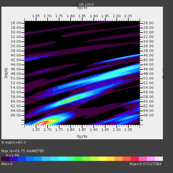
| Crust2 Type: | D8,thick Platform 3 km seds. |
| Thickness Estimate: | 70 km |
| Thickness StdDev: | 10 km |
| Vp/Vs Estimate: | 1.66 |
| Vp/Vs StdDev: | 0.19 |
| Vs Estimate: | 3.871 km/s |
| Poisson's Ratio: | 0.22 |
| Peak Value: | 0.07 |
| Assumed Vp: | 6.426 km/s |
| Ps Weight: | 0.33333334 |
| PpPs Weight: | 0.33333334 |
| PsPs Weight: | 0.33333328 |
| Residual Complexity: | 0.729 |
| Nearby stations H: | +- |
| (2.0 deg) Vp/Vs: | +- |
0 with match > 90% ( 0.0 %) and 2 with match > 80% ( 13.333333 %) out of 15.
Download stack as xyz text file.
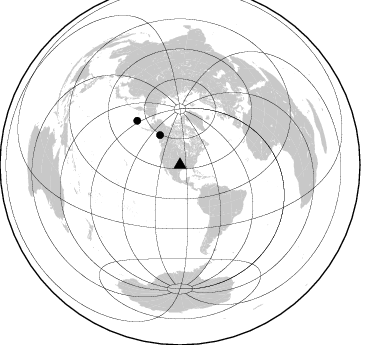
Azimuth Distribution of Events:
Prior Results for this Station
| Study | Thickness | Vp/Vs | Vp | Vs | Poissons Ratio | Extra |
| EARS | 70 km | 1.66 | 6.426 km/s | 3.871 km/s | 0.22 | |
| Crust2.0 | 46 km | 1.78 | 6.426 km/s | 3.613 km/s | 0.27 | D8,thick Platform 3 km seds. |
| Global Maxima | 70 km | 1.66 | 6.426 km/s | 3.871 km/s | 0.22 | amp=0.07017084 |
| Local Maxima 1 | 58 km | 1.81 | 6.426 km/s | 3.545 km/s | 0.28 | amp=0.034503426 |
| Local Maxima 2 | 45 km | 2.05 | 6.426 km/s | 3.139 km/s | 0.34 | amp=0.023459334 |
| Local Maxima 3 | 40 km | 2.04 | 6.426 km/s | 3.154 km/s | 0.34 | amp=0.02078708 |
| Local Maxima 4 | 49 km | 1.92 | 6.426 km/s | 3.338 km/s | 0.32 | amp=0.01981593 |
| Predicted Arrivals for vertical incidence (zero ray parameter) | |
| Ps | 7.16 SECOND |
| PpPs | 28.87 SECOND |
| PsPs/PpSs | 36.04 SECOND |
Events Processed for this Station
Download zip of receiver functions as SAC
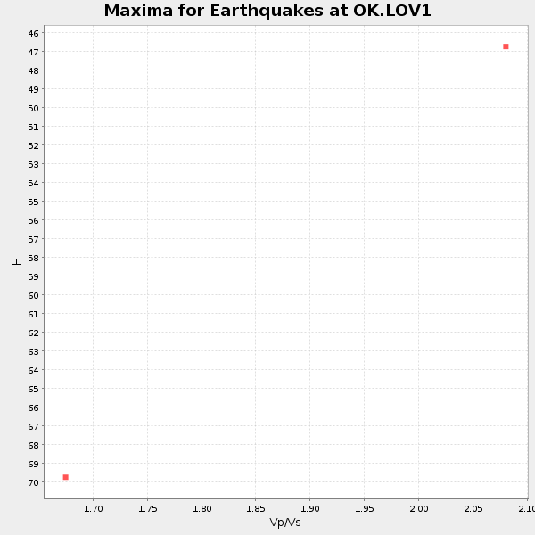
Plot maxima for each earthquake.
Events Used in the Stack
(2 events)| Radial Match | Distance | Baz | FERegion | Time | Lat/Lon | Depth | Magnitude |
| 82.09895 | 61.6 deg | 315.822 deg | Rat Islands, Aleutian Islands | 2014/06/24 03:15:36 GMT | (52.3, 176.7) | 4.0 km | 6.3 MWB, 5.7 ML, 6.4 MWC, 6.6 MI |
| 80.81378 | 36.0 deg | 326.012 deg | Southeastern Alaska | 2014/06/04 11:58:58 GMT | (59.0, -136.7) | 10 km | 5.7 MWP, 5.8 ML, 5.8 MI |
Losers
(13 events)| Radial Match | Distance | Baz | FERegion | Time | Lat/Lon | Depth | Magnitude | Reason |
| 77.94238 | 54.7 deg | 313.128 deg | Fox Islands, Aleutian Islands | 2014/06/20 12:16:46 GMT | (51.9, -171.4) | 26 km | 5.6 MB, 5.0 ML, 5.1 ML, 5.3 MWB | |
| 73.762825 | 49.6 deg | 333.181 deg | Northern Alaska | 2014/06/07 04:43:34 GMT | (67.9, -162.4) | 14 km | 6.0 MI | |
| 72.13816 | 60.7 deg | 315.144 deg | Rat Islands, Aleutian Islands | 2014/06/24 00:52:28 GMT | (52.0, 178.4) | 103 km | 5.7 MB | |
| 62.667847 | 90.8 deg | 317.129 deg | Near East Coast Of Honshu, Japan | 2014/06/15 20:14:50 GMT | (37.1, 141.1) | 40 km | 5.6 MB | |
| 61.844513 | 59.2 deg | 150.826 deg | Near Coast Of Northern Chile | 2014/06/19 19:54:05 GMT | (-19.8, -70.8) | 11 km | 5.7 MWB | |
| 59.59332 | 59.3 deg | 150.997 deg | Near Coast Of Northern Chile | 2014/06/19 09:38:37 GMT | (-20.0, -70.9) | 19 km | 5.7 MWP | |
| 55.58237 | 59.2 deg | 150.852 deg | Near Coast Of Northern Chile | 2014/06/20 19:53:32 GMT | (-19.8, -70.9) | 14 km | 5.5 MB | |
| 55.245686 | 60.7 deg | 315.18 deg | Rat Islands, Aleutian Islands | 2014/06/23 22:47:53 GMT | (52.0, 178.4) | 116 km | 4.8 mb | |
| 53.825527 | 64.6 deg | 151.664 deg | Northern Chile | 2014/06/14 22:13:30 GMT | (-25.0, -69.0) | 101 km | 5.0 MW | |
| 51.572628 | 60.7 deg | 315.105 deg | Rat Islands, Aleutian Islands | 2014/06/25 00:03:05 GMT | (52.0, 178.5) | 116 km | 5.1 MW | |
| 45.462566 | 73.3 deg | 320.26 deg | Kuril Islands | 2014/06/07 13:11:37 GMT | (50.7, 157.1) | 56 km | 5.6 M | |
| 43.82807 | 55.7 deg | 23.895 deg | Jan Mayen Island Region | 2014/06/16 14:24:31 GMT | (70.4, -15.2) | 11 km | 5.5 MW | |
| 41.534626 | 66.6 deg | 321.464 deg | Komandorskiye Ostrova Region | 2014/05/31 06:16:56 GMT | (55.0, 165.7) | 20 km | 5.5 MW |

