
Station ON ABR01 - OBSN: [ABR01] Abrolhos, BA
Network: ON - RSIS-Rede Sismografica do Sul e Sudeste Observatorio Nacional, Brazil
Nearby stations (2 deg radius)
| Station | Name | (Lat, Lon) | Start / End | Elevation |
| ABR01 | OBSN: [ABR01] Abrolhos, BA | (-17.96, -38.70) | 2014-12-13 / 2500-01-01 | 38 m |
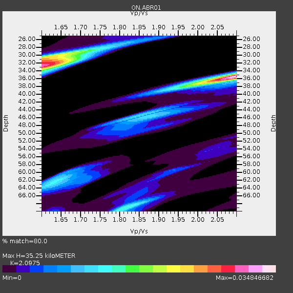
| Crust2 Type: | T4,Margin /shield transition, East Siberia, 2 km seds. |
| Thickness Estimate: | 35 km |
| Thickness StdDev: | 10 km |
| Vp/Vs Estimate: | 2.10 |
| Vp/Vs StdDev: | 0.24 |
| Vs Estimate: | 3.047 km/s |
| Poisson's Ratio: | 0.35 |
| Peak Value: | 0.03 |
| Assumed Vp: | 6.391 km/s |
| Ps Weight: | 0.33333334 |
| PpPs Weight: | 0.33333334 |
| PsPs Weight: | 0.33333328 |
| Residual Complexity: | 0.805 |
| Nearby stations H: | +- |
| (2.0 deg) Vp/Vs: | +- |
4 with match > 90% ( 12.5 %) and 6 with match > 80% ( 18.75 %) out of 32.
Download stack as xyz text file.
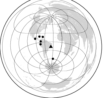
Azimuth Distribution of Events:
Prior Results for this Station
| Study | Thickness | Vp/Vs | Vp | Vs | Poissons Ratio | Extra |
| EARS | 35 km | 2.10 | 6.391 km/s | 3.047 km/s | 0.35 | |
| Crust2.0 | 32 km | 1.79 | 6.391 km/s | 3.572 km/s | 0.27 | T4,Margin /shield transition, East Siberia, 2 km seds. |
| Global Maxima | 35 km | 2.10 | 6.391 km/s | 3.047 km/s | 0.35 | amp=0.034846682 |
| Local Maxima 1 | 32 km | 1.60 | 6.391 km/s | 3.988 km/s | 0.18 | amp=0.030498493 |
| Local Maxima 2 | 31 km | 1.60 | 6.391 km/s | 3.994 km/s | 0.18 | amp=0.020436991 |
| Local Maxima 3 | 69 km | 1.81 | 6.391 km/s | 3.531 km/s | 0.28 | amp=0.014669446 |
| Local Maxima 4 | 62 km | 1.65 | 6.391 km/s | 3.879 km/s | 0.21 | amp=0.010843526 |
| Predicted Arrivals for vertical incidence (zero ray parameter) | |
| Ps | 6.05 SECOND |
| PpPs | 17.09 SECOND |
| PsPs/PpSs | 23.14 SECOND |
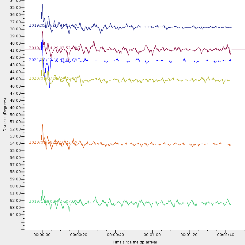
Events Processed for this Station
Download zip of receiver functions as SAC
Plot maxima for each earthquake.
Events Used in the Stack
(6 events)| Radial Match | Distance | Baz | FERegion | Time | Lat/Lon | Depth | Magnitude |
| 97.78114 | 54.1 deg | 311.286 deg | Cuba Region | 2020/01/28 19:10:23 UTC | (19.3, -78.8) | 10 km | 7.3 Mi |
| 96.15821 | 42.5 deg | 170.172 deg | South Sandwich Islands Region | 2021/08/12 18:47:04 UTC | (-59.5, -25.6) | 35 km | 5.6 mb |
| 95.59209 | 37.7 deg | 283.975 deg | Northern Peru | 2019/05/26 07:41:13 UTC | (-5.9, -75.3) | 105 km | 7.5 Mi |
| 92.46899 | 45.1 deg | 320.714 deg | Puerto Rico Region | 2020/01/07 08:24:26 UTC | (17.9, -66.8) | 10 km | 6.4 mww |
| 80.70593 | 62.4 deg | 296.922 deg | Off Coast Of Chiapas, Mexico | 2019/11/20 04:27:07 UTC | (14.0, -93.1) | 26 km | 6.3 Mww |
| 80.4487 | 40.9 deg | 298.022 deg | Colombia | 2019/12/24 19:03:52 UTC | (3.5, -74.0) | 11 km | 6.0 Mww |
Losers
(26 events)| Radial Match | Distance | Baz | FERegion | Time | Lat/Lon | Depth | Magnitude | Reason |
| 84.90618 | 80.0 deg | 40.316 deg | Albania | 2019/11/26 06:08:22 UTC | (41.6, 19.4) | 10 km | 5.4 Mww | |
| 81.86173 | 43.2 deg | 171.232 deg | South Sandwich Islands Region | 2021/08/12 18:41:58 UTC | (-60.3, -26.6) | 35 km | 6.1 mb | |
| 79.113686 | 91.8 deg | 307.132 deg | Central California | 2019/07/06 04:18:55 UTC | (35.9, -117.7) | 7.4 km | 5.4 Mw | |
| 76.62158 | 45.1 deg | 320.664 deg | Puerto Rico Region | 2020/01/11 12:54:44 UTC | (17.9, -66.8) | 5.0 km | 6.0 Mi | |
| 76.49903 | 50.9 deg | 297.098 deg | Panama-Costa Rica Border Region | 2021/01/29 13:14:44 UTC | (8.3, -83.0) | 10 km | 5.5 Mww | |
| 76.10884 | 32.3 deg | 241.408 deg | Near Coast Of Central Chile | 2020/09/06 01:16:58 UTC | (-30.3, -71.6) | 31 km | 6.3 Mww | |
| 74.29887 | 62.0 deg | 296.941 deg | Off Coast Of Chiapas, Mexico | 2020/02/02 03:32:44 UTC | (13.8, -92.8) | 10 km | 5.6 Mww | |
| 71.07296 | 60.7 deg | 297.657 deg | Near Coast Of Guatemala | 2019/12/19 12:35:32 UTC | (13.7, -91.3) | 31 km | 5.9 Mww | |
| 67.89294 | 31.6 deg | 245.67 deg | Near Coast Of Northern Chile | 2020/09/01 05:29:38 UTC | (-28.0, -71.3) | 16 km | 5.5 Mww | |
| 67.22965 | 43.3 deg | 297.561 deg | Colombia | 2019/03/23 19:21:16 UTC | (4.6, -76.3) | 113 km | 6.1 Mww | |
| 65.497604 | 42.3 deg | 173.12 deg | South Sandwich Islands Region | 2021/03/14 12:05:13 UTC | (-59.8, -29.5) | 10 km | 6.0 mww | |
| 64.8149 | 38.8 deg | 168.822 deg | South Sandwich Islands Region | 2019/11/02 18:08:41 UTC | (-55.7, -26.3) | 10 km | 6.1 Mww | |
| 64.53865 | 30.7 deg | 270.202 deg | Southern Peru | 2020/05/31 05:09:35 UTC | (-15.3, -70.7) | 153 km | 6.0 mww | |
| 63.72865 | 69.9 deg | 261.694 deg | Central East Pacific Rise | 2021/02/10 08:22:31 UTC | (-13.6, -111.6) | 10 km | 5.6 Mww | |
| 60.985043 | 73.2 deg | 128.356 deg | Crozet Islands Region | 2021/05/20 17:05:17 UTC | (-41.0, 44.2) | 10 km | 5.7 Mww | |
| 57.34853 | 45.1 deg | 320.804 deg | Puerto Rico Region | 2020/01/07 08:34:02 UTC | (17.9, -66.7) | 10 km | 5.6 Mww | |
| 57.25789 | 91.4 deg | 50.27 deg | Turkey | 2020/08/04 09:37:37 UTC | (38.2, 38.7) | 10 km | 5.5 mww | |
| 56.57371 | 59.6 deg | 297.922 deg | Near Coast Of Guatemala | 2021/05/12 08:45:48 UTC | (13.3, -90.2) | 46 km | 5.9 mww | |
| 56.20833 | 65.6 deg | 273.715 deg | Central East Pacific Rise | 2020/09/21 13:37:15 UTC | (-4.1, -104.4) | 10 km | 5.9 Mww | |
| 54.30192 | 49.6 deg | 295.78 deg | South Of Panama | 2021/05/13 09:42:12 UTC | (6.8, -82.4) | 10 km | 6.0 mww | |
| 54.078365 | 82.3 deg | 49.333 deg | Dodecanese Islands, Greece | 2020/01/30 01:28:06 UTC | (35.2, 27.9) | 10 km | 5.6 mww | |
| 49.672615 | 33.3 deg | 342.629 deg | North Atlantic Ocean | 2021/05/07 11:45:25 UTC | (14.1, -48.4) | 10 km | 5.5 mww | |
| 48.56827 | 66.8 deg | 272.719 deg | Central East Pacific Rise | 2019/05/16 22:52:43 UTC | (-4.6, -105.7) | 10 km | 5.8 Mww | |
| 44.668964 | 50.2 deg | 71.914 deg | Off S. Coast Of Northwest Africa | 2019/12/19 15:25:59 UTC | (1.8, 8.2) | 10 km | 5.5 Mww | |
| 30.16242 | 91.8 deg | 307.107 deg | Central California | 2019/07/06 03:47:53 UTC | (35.9, -117.7) | 3.4 km | 5.4 Mww | |
| 29.564838 | 31.3 deg | 267.537 deg | Southern Peru | 2020/12/16 17:48:44 UTC | (-16.6, -71.4) | 87 km | 5.6 mww |

