
Station ON MAJ01 - OBSN: [MAJ01] Major Gercino, SC
Network: ON - RSIS-Rede Sismografica do Sul e Sudeste Observatorio Nacional, Brazil
Nearby stations (2 deg radius)
| Station | Name | (Lat, Lon) | Start / End | Elevation |
| MAJ01 | OBSN: [MAJ01] Major Gercino, SC | (-27.40, -49.01) | 2011-11-28 / 2500-01-01 | 344 m |
| Crust2 Type: | G2,Archean 0.5 km seds. |
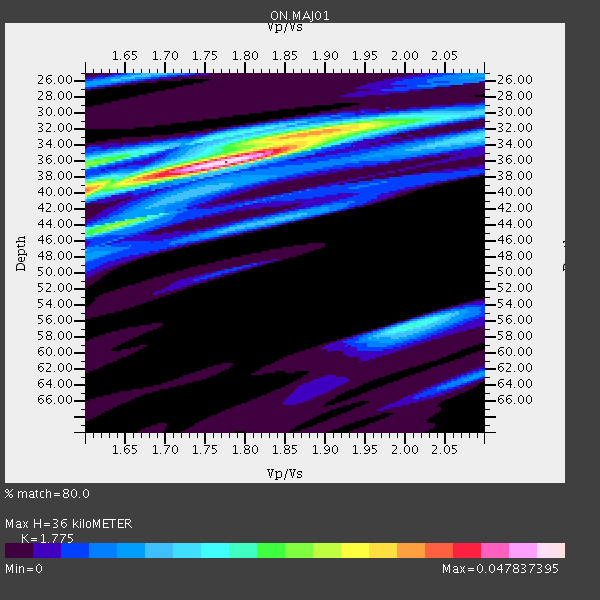
| Thickness Estimate: | 36 km |
| Thickness StdDev: | 3.1 km |
| Vp/Vs Estimate: | 1.77 |
| Vp/Vs StdDev: | 0.10 |
| Vs Estimate: | 3.616 km/s |
| Poisson's Ratio: | 0.27 |
| Peak Value: | 0.05 |
| Assumed Vp: | 6.419 km/s |
| Ps Weight: | 0.33333334 |
| PpPs Weight: | 0.33333334 |
| PsPs Weight: | 0.33333328 |
| Residual Complexity: | 0.623 |
| Nearby stations H: | +- |
| (2.0 deg) Vp/Vs: | +- |
1 with match > 90% ( 9.090909 %) and 3 with match > 80% ( 27.272728 %) out of 11.
Download stack as xyz text file.
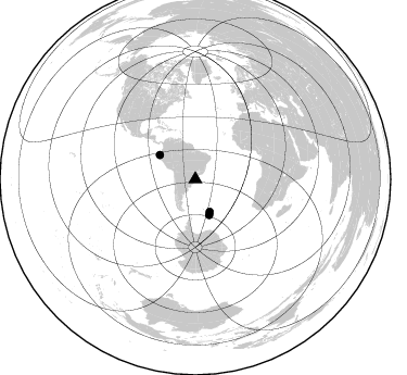
Azimuth Distribution of Events:
Prior Results for this Station
| Study | Thickness | Vp/Vs | Vp | Vs | Poissons Ratio | Extra |
| EARS | 36 km | 1.77 | 6.419 km/s | 3.616 km/s | 0.27 | |
| Crust2.0 | 39 km | 1.77 | 6.419 km/s | 3.636 km/s | 0.26 | G2,Archean 0.5 km seds. |
| Global Maxima | 36 km | 1.77 | 6.419 km/s | 3.616 km/s | 0.27 | amp=0.047837395 |
| Local Maxima 1 | 32 km | 1.90 | 6.419 km/s | 3.379 km/s | 0.31 | amp=0.031309787 |
| Local Maxima 2 | 40 km | 1.60 | 6.419 km/s | 4.012 km/s | 0.18 | amp=0.02970559 |
| Local Maxima 3 | 56 km | 2.01 | 6.419 km/s | 3.19 km/s | 0.34 | amp=0.021099936 |
| Local Maxima 4 | 36 km | 1.60 | 6.419 km/s | 4.012 km/s | 0.18 | amp=0.017541332 |
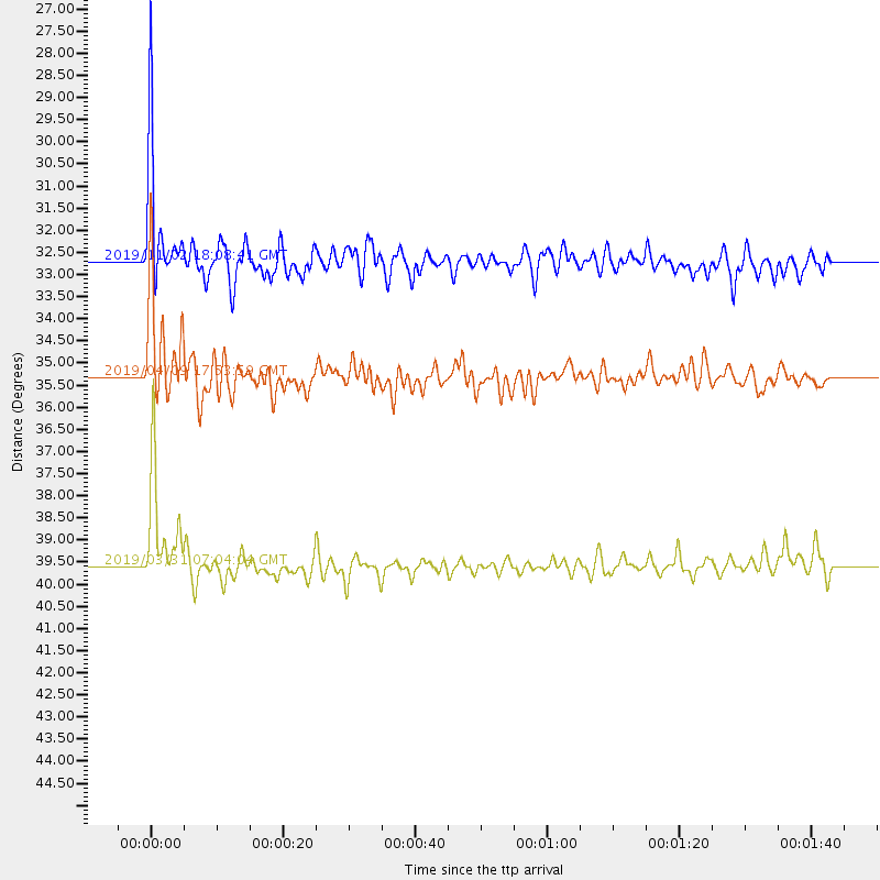
| Predicted Arrivals for vertical incidence (zero ray parameter) | |
| Ps | 4.35 SECOND |
| PpPs | 15.56 SECOND |
| PsPs/PpSs | 19.91 SECOND |
Events Processed for this Station
Download zip of receiver functions as SAC
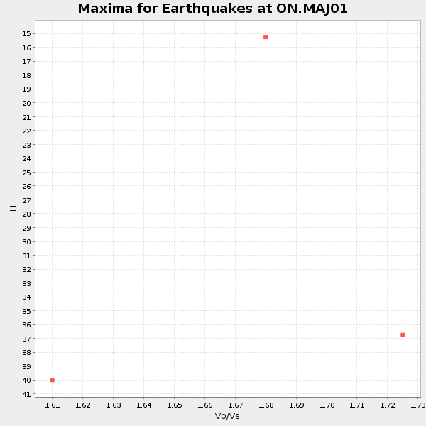
Plot maxima for each earthquake.
Events Used in the Stack
(3 events)| Radial Match | Distance | Baz | FERegion | Time | Lat/Lon | Depth | Magnitude |
| 91.33993 | 39.6 deg | 304.224 deg | Near Coast Of Ecuador | 2019/03/31 07:04:04 GMT | (-2.0, -80.8) | 19 km | 6.2 Mww |
| 82.24203 | 32.7 deg | 156.119 deg | South Sandwich Islands Region | 2019/11/02 18:08:41 GMT | (-55.7, -26.3) | 10 km | 6.1 Mww |
| 82.07338 | 35.3 deg | 158.609 deg | South Sandwich Islands Region | 2019/04/09 17:53:59 GMT | (-58.6, -25.3) | 46 km | 6.5 Mww |
Losers
(8 events)| Radial Match | Distance | Baz | FERegion | Time | Lat/Lon | Depth | Magnitude | Reason |
| 78.52755 | 90.0 deg | 310.702 deg | Central California | 2019/07/04 17:35:01 GMT | (35.6, -117.6) | 4.6 km | 4.5 Mlr | |
| 77.55402 | 32.3 deg | 157.671 deg | South Sandwich Islands Region | 2019/04/05 16:14:16 GMT | (-55.9, -27.8) | 58 km | 6.5 mww | |
| 76.87766 | 41.3 deg | 316.171 deg | Colombia | 2019/03/23 19:21:16 GMT | (4.6, -76.3) | 113 km | 6.1 Mww | |
| 73.99654 | 90.3 deg | 310.834 deg | Central California | 2019/07/06 03:47:53 GMT | (35.9, -117.7) | 3.4 km | 5.4 Mww | |
| 71.66128 | 42.9 deg | 59.669 deg | North Of Ascension Island | 2019/06/29 19:51:20 GMT | (-1.7, -13.0) | 10 km | 5.5 Mww | |
| 65.941 | 57.8 deg | 310.93 deg | Guatemala | 2019/11/09 08:32:52 GMT | (14.5, -90.3) | 197 km | 5.6 Mww | |
| 61.603947 | 91.5 deg | 308.47 deg | Southern California | 2019/06/12 14:17:30 GMT | (34.6, -120.5) | 0.0 km | 0.0 Mun | |
| 61.53254 | 32.8 deg | 157.666 deg | South Sandwich Islands Region | 2019/04/22 14:49:06 GMT | (-56.3, -27.4) | 94 km | 6.0 Mww |

