
Station ON SLP01 - OBSN: [SLP01] Sao Luis do Paraitinga, SP
Network: ON - RSIS-Rede Sismografica do Sul e Sudeste Observatorio Nacional, Brazil
Nearby stations (2 deg radius)
| Station | Name | (Lat, Lon) | Start / End | Elevation |
| SLP01 | OBSN: [SLP01] Sao Luis do Paraitinga, SP | (-23.32, -45.16) | 2011-05-06 / 2500-01-01 | 1117 m |
| Crust2 Type: | T6,Margin /shield transition, 1 km seds. |
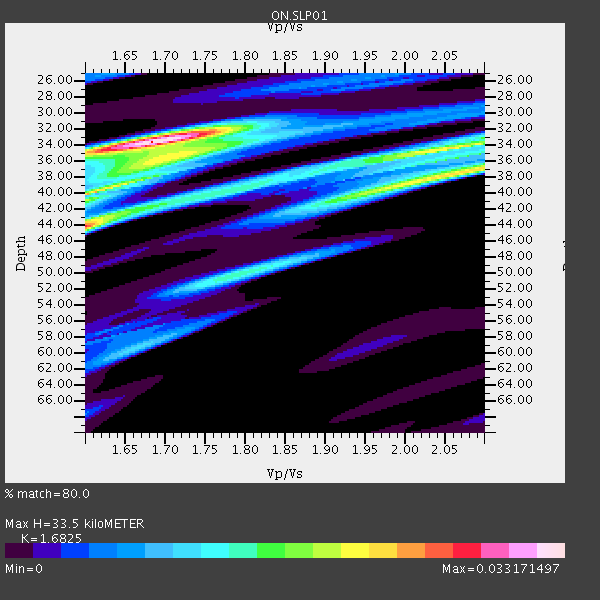
| Thickness Estimate: | 34 km |
| Thickness StdDev: | 1.8 km |
| Vp/Vs Estimate: | 1.68 |
| Vp/Vs StdDev: | 0.20 |
| Vs Estimate: | 3.847 km/s |
| Poisson's Ratio: | 0.23 |
| Peak Value: | 0.03 |
| Assumed Vp: | 6.472 km/s |
| Ps Weight: | 0.33333334 |
| PpPs Weight: | 0.33333334 |
| PsPs Weight: | 0.33333328 |
| Residual Complexity: | 0.768 |
| Nearby stations H: | +- |
| (2.0 deg) Vp/Vs: | +- |
3 with match > 90% ( 33.333332 %) and 4 with match > 80% ( 44.444443 %) out of 9.
Download stack as xyz text file.
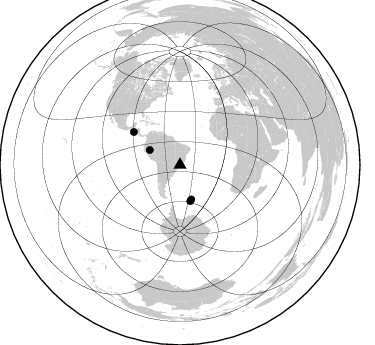
Azimuth Distribution of Events:
Prior Results for this Station
| Study | Thickness | Vp/Vs | Vp | Vs | Poissons Ratio | Extra |
| EARS | 34 km | 1.68 | 6.472 km/s | 3.847 km/s | 0.23 | |
| Crust2.0 | 32 km | 1.79 | 6.472 km/s | 3.622 km/s | 0.27 | T6,Margin /shield transition, 1 km seds. |
| Global Maxima | 34 km | 1.68 | 6.472 km/s | 3.847 km/s | 0.23 | amp=0.033171497 |
| Local Maxima 1 | 44 km | 1.60 | 6.472 km/s | 4.045 km/s | 0.18 | amp=0.026752258 |
| Local Maxima 2 | 34 km | 2.08 | 6.472 km/s | 3.119 km/s | 0.35 | amp=0.021091795 |
| Local Maxima 3 | 35 km | 1.72 | 6.472 km/s | 3.768 km/s | 0.24 | amp=0.016606133 |
| Local Maxima 4 | 39 km | 1.99 | 6.472 km/s | 3.248 km/s | 0.33 | amp=0.014884874 |
| Predicted Arrivals for vertical incidence (zero ray parameter) | |
| Ps | 3.53 SECOND |
| PpPs | 13.89 SECOND |
| PsPs/PpSs | 17.42 SECOND |
Events Processed for this Station
Download zip of receiver functions as SAC
Plot maxima for each earthquake.
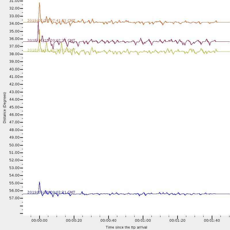
Events Used in the Stack
(4 events)| Radial Match | Distance | Baz | FERegion | Time | Lat/Lon | Depth | Magnitude |
| 95.865135 | 33.8 deg | 296.108 deg | Northern Peru | 2019/05/26 07:41:13 GMT | (-5.9, -75.3) | 105 km | 7.5 Mi |
| 95.35924 | 56.4 deg | 305.381 deg | El Salvador | 2019/05/30 09:03:31 GMT | (13.1, -89.4) | 10 km | 6.6 Mi |
| 91.24127 | 37.7 deg | 164.071 deg | South Sandwich Islands Region | 2018/12/11 02:26:32 GMT | (-58.6, -26.5) | 165 km | 7.1 mww |
| 83.34051 | 36.4 deg | 161.716 deg | South Sandwich Islands Region | 2018/11/15 20:02:21 GMT | (-56.8, -25.4) | 10 km | 6.3 mww |
Losers
(5 events)| Radial Match | Distance | Baz | FERegion | Time | Lat/Lon | Depth | Magnitude | Reason |
| 88.55803 | 67.3 deg | 217.429 deg | Pacific-Antarctic Ridge | 2018/12/12 13:13:57 GMT | (-55.8, -128.5) | 10 km | 6.3 Mww | |
| 76.60718 | 35.4 deg | 162.906 deg | South Sandwich Islands Region | 2019/04/22 14:49:06 GMT | (-56.3, -27.4) | 94 km | 6.0 Mww | |
| 70.316925 | 57.1 deg | 304.461 deg | Off Coast Of Central America | 2018/10/28 22:23:54 GMT | (12.9, -90.4) | 25 km | 6.1 Mww | |
| 64.598724 | 37.6 deg | 162.699 deg | South Sandwich Islands Region | 2018/11/01 19:30:20 GMT | (-58.1, -25.2) | 29 km | 5.8 Mww | |
| 62.825386 | 43.1 deg | 153.209 deg | East Of South Sandwich Islands | 2018/09/27 10:25:47 GMT | (-58.2, -9.6) | 10 km | 5.7 Mww |

