
Station OV CABA - Caballito Guanacaste
Network: OV - Observatorio Vulcanol?gico y Sismol?gico de Costa Rica
Nearby stations (2 deg radius)
| Station | Name | (Lat, Lon) | Start / End | Elevation |
| CABA | Caballito Guanacaste | (10.24, -85.34) | 2000-01-01 / 2599-12-31 | 35 m |
| Crust2 Type: | L3,continental arc, Southern Andes, 0.2 km seds. |
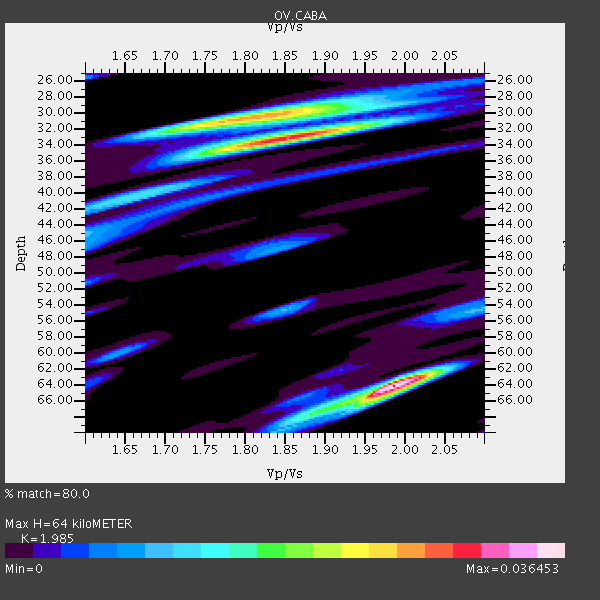
| Thickness Estimate: | 64 km |
| Thickness StdDev: | 14 km |
| Vp/Vs Estimate: | 1.99 |
| Vp/Vs StdDev: | 0.11 |
| Vs Estimate: | 3.324 km/s |
| Poisson's Ratio: | 0.33 |
| Peak Value: | 0.04 |
| Assumed Vp: | 6.597 km/s |
| Ps Weight: | 0.33333334 |
| PpPs Weight: | 0.33333334 |
| PsPs Weight: | 0.33333328 |
| Residual Complexity: | 0.861 |
| Nearby stations H: | +- |
| (2.0 deg) Vp/Vs: | +- |
0 with match > 90% ( 0.0 %) and 5 with match > 80% ( 15.151515 %) out of 33.
Download stack as xyz text file.
Azimuth Distribution of Events:

Prior Results for this Station
| Study | Thickness | Vp/Vs | Vp | Vs | Poissons Ratio | Extra |
| EARS | 64 km | 1.99 | 6.597 km/s | 3.324 km/s | 0.33 | |
| Crust2.0 | 40 km | 1.77 | 6.597 km/s | 3.723 km/s | 0.27 | L3,continental arc, Southern Andes, 0.2 km seds. |
| Global Maxima | 64 km | 1.99 | 6.597 km/s | 3.324 km/s | 0.33 | amp=0.036453 |
| Local Maxima 1 | 33 km | 1.85 | 6.597 km/s | 3.561 km/s | 0.29 | amp=0.031024199 |
| Local Maxima 2 | 31 km | 1.79 | 6.597 km/s | 3.696 km/s | 0.27 | amp=0.025410945 |
| Local Maxima 3 | 68 km | 1.88 | 6.597 km/s | 3.519 km/s | 0.30 | amp=0.011436425 |
| Local Maxima 4 | 41 km | 1.63 | 6.597 km/s | 4.048 km/s | 0.20 | amp=0.010901726 |
| Predicted Arrivals for vertical incidence (zero ray parameter) | |
| Ps | 9.56 SECOND |
| PpPs | 28.96 SECOND |
| PsPs/PpSs | 38.51 SECOND |
Events Processed for this Station
Download zip of receiver functions as SAC
Plot maxima for each earthquake.
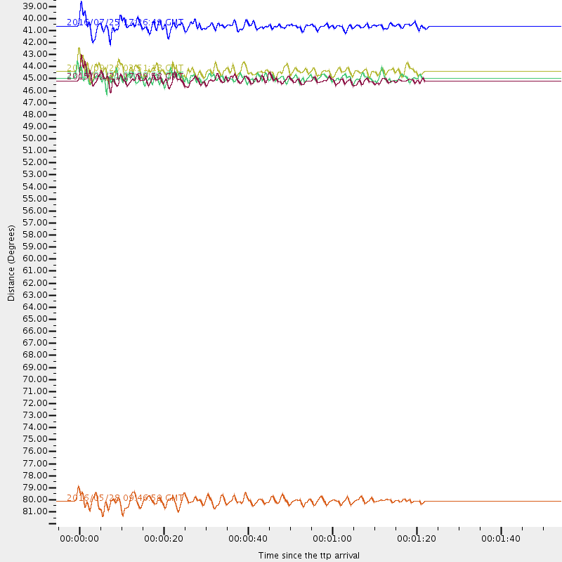
Events Used in the Stack
(5 events)| Radial Match | Distance | Baz | FERegion | Time | Lat/Lon | Depth | Magnitude |
| 85.77969 | 81.9 deg | 151.245 deg | South Sandwich Islands Region | 2016/05/28 09:46:59 GMT | (-56.2, -26.9) | 73 km | 7.2 MWW, 7.3 MI |
| 85.068825 | 43.8 deg | 163.026 deg | Near Coast Of Central Chile | 2015/09/21 17:39:58 GMT | (-31.7, -71.6) | 25 km | 6.5 MB, 6.5 MI, 6.6 MWW |
| 84.43333 | 38.8 deg | 158.674 deg | Near Coast Of Northern Chile | 2016/07/25 17:26:49 GMT | (-26.1, -70.6) | 68 km | 6.2 MB |
| 82.36101 | 43.6 deg | 163.039 deg | Near Coast Of Central Chile | 2015/09/21 05:39:33 GMT | (-31.6, -71.7) | 23 km | 6.3 MWP |
| 80.11424 | 43.0 deg | 162.274 deg | Near Coast Of Central Chile | 2015/09/26 02:51:18 GMT | (-30.8, -71.4) | 38 km | 6.2 MO |
Losers
(28 events)| Radial Match | Distance | Baz | FERegion | Time | Lat/Lon | Depth | Magnitude | Reason |
| 99.835815 | 85.4 deg | 210.1 deg | Pacific-Antarctic Ridge | 2014/12/13 19:24:59 GMT | (-56.8, -150.5) | 10 km | 5.0 mb | |
| 80.32854 | 94.0 deg | 248.345 deg | Tonga Islands Region | 2015/01/14 05:29:34 GMT | (-22.1, -175.6) | 100 km | 5.1 MW, 4.7 mb | |
| 78.148926 | 81.5 deg | 151.526 deg | South Sandwich Islands Region | 2015/09/30 16:06:52 GMT | (-56.2, -27.7) | 106 km | 5.7 MB | |
| 77.95363 | 43.6 deg | 162.386 deg | Near Coast Of Central Chile | 2015/09/22 07:12:59 GMT | (-31.5, -71.2) | 54 km | 6.1 MWB | |
| 75.841125 | 37.2 deg | 153.392 deg | Northern Chile | 2015/11/01 15:16:14 GMT | (-23.2, -68.2) | 80 km | 5.8 MB | |
| 75.21087 | 81.5 deg | 151.474 deg | South Sandwich Islands Region | 2016/02/18 01:07:14 GMT | (-56.2, -27.6) | 119 km | 5.8 MB | |
| 74.93188 | 42.4 deg | 162.236 deg | Near Coast Of Central Chile | 2015/10/03 06:26:55 GMT | (-30.3, -71.6) | 40 km | 5.8 MWR | |
| 73.415085 | 71.2 deg | 326.519 deg | Alaska Peninsula | 2015/05/29 07:00:08 GMT | (56.7, -156.5) | 62 km | 6.8 MWP, 6.8 MI | |
| 73.01248 | 43.2 deg | 162.687 deg | Near Coast Of Central Chile | 2015/09/19 09:07:08 GMT | (-31.1, -71.6) | 23 km | 6.1 MWP | |
| 71.13982 | 37.6 deg | 149.8 deg | Jujuy Province, Argentina | 2016/08/04 14:15:11 GMT | (-22.4, -66.0) | 258 km | 6.0 MO | |
| 68.91405 | 43.6 deg | 163.524 deg | Off Coast Of Central Chile | 2015/09/17 01:33:03 GMT | (-31.7, -72.1) | 15 km | 5.6 MB | |
| 66.59888 | 96.5 deg | 327.771 deg | Kamchatka Peninsula, Russia | 2016/01/30 03:25:10 GMT | (54.0, 158.5) | 161 km | 7.2 MWW, 7.0 MI, 7.2 MWB | |
| 66.55464 | 46.1 deg | 162.697 deg | Chile-Argentina Border Region | 2016/04/14 09:38:44 GMT | (-33.9, -70.4) | 112 km | 5.5 MB | |
| 66.302536 | 81.9 deg | 151.509 deg | South Sandwich Islands Region | 2016/03/14 07:26:43 GMT | (-56.4, -27.1) | 104 km | 5.7 MB | |
| 65.259224 | 36.1 deg | 152.775 deg | Northern Chile | 2015/05/26 10:32:01 GMT | (-22.1, -68.4) | 115 km | 5.7 MB | |
| 64.919304 | 91.0 deg | 254.938 deg | Tonga Islands | 2016/07/23 20:09:19 GMT | (-15.1, -173.6) | 10 km | 5.7 MB | |
| 64.39323 | 95.3 deg | 243.393 deg | Kermadec Islands Region | 2015/07/30 18:35:17 GMT | (-27.2, -176.2) | 12 km | 5.5 MW | |
| 63.5937 | 38.5 deg | 151.741 deg | Jujuy Province, Argentina | 2015/09/28 15:28:05 GMT | (-23.8, -66.6) | 219 km | 5.9 MWW, 6.0 MWB, 6.0 MWC | |
| 63.53099 | 42.5 deg | 163.081 deg | Off Coast Of Central Chile | 2015/09/19 13:08:57 GMT | (-30.6, -72.2) | 14 km | 5.6 MB | |
| 58.117992 | 83.0 deg | 152.077 deg | South Sandwich Islands Region | 2015/08/26 13:51:39 GMT | (-57.5, -26.0) | 64 km | 5.7 MB | |
| 58.072037 | 47.7 deg | 316.378 deg | Off Coast Of Northern California | 2015/04/24 01:34:55 GMT | (40.4, -127.2) | 10 km | 5.5 MB | |
| 57.78278 | 90.5 deg | 252.269 deg | Tonga Islands Region | 2016/06/05 22:33:49 GMT | (-17.6, -172.6) | 10 km | 5.6 MWW, 5.6 MWC, 5.6 MWB | |
| 56.197132 | 45.6 deg | 164.911 deg | Off Coast Of Central Chile | 2015/06/02 10:32:46 GMT | (-33.9, -72.4) | 20 km | 5.1 MW | |
| 55.846447 | 84.5 deg | 321.612 deg | Andreanof Islands, Aleutian Is. | 2015/10/05 17:35:55 GMT | (51.9, -179.3) | 89 km | 5.7 MB | |
| 55.292618 | 88.1 deg | 139.681 deg | Southern Mid-Atlantic Ridge | 2015/08/02 05:29:33 GMT | (-48.3, -9.9) | 10 km | 5.1 MW | |
| 52.57886 | 83.8 deg | 153.047 deg | South Sandwich Islands Region | 2016/08/02 07:32:29 GMT | (-58.7, -25.6) | 35 km | 5.5 MWW, 5.4 MWB, 5.6 MWC | |
| 52.141212 | 95.3 deg | 243.44 deg | Kermadec Islands Region | 2015/08/11 13:35:51 GMT | (-27.2, -176.1) | 28 km | 5.5 MW | |
| 50.434505 | 86.1 deg | 321.17 deg | Rat Islands, Aleutian Islands | 2015/05/31 18:07:49 GMT | (51.2, 178.3) | 36 km | 5.0 MW, 5.1 mb, 4.0 MS |

