
Station OV HAYA - Volcan Irazu
Network: OV - Observatorio Vulcanol?gico y Sismol?gico de Costa Rica
Nearby stations (2 deg radius)
| Station | Name | (Lat, Lon) | Start / End | Elevation |
| HAYA | Volcan Irazu | (9.98, -83.84) | 2015-09-02 / 2599-12-31 | 3245 m |
| Crust2 Type: | LA,very thin continental arc, Cordilleras, 1.0 km seds. |
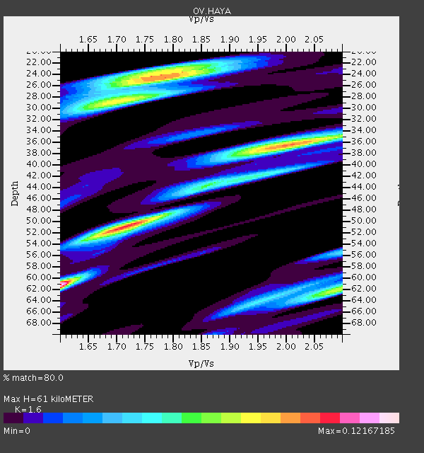
| Thickness Estimate: | 61 km |
| Thickness StdDev: | 14 km |
| Vp/Vs Estimate: | 1.60 |
| Vp/Vs StdDev: | 0.14 |
| Vs Estimate: | 4.022 km/s |
| Poisson's Ratio: | 0.18 |
| Peak Value: | 0.12 |
| Assumed Vp: | 6.436 km/s |
| Ps Weight: | 0.33333334 |
| PpPs Weight: | 0.33333334 |
| PsPs Weight: | 0.33333328 |
| Residual Complexity: | 0.921 |
| Nearby stations H: | 44 km +- 24 km |
| (2.0 deg) Vp/Vs: | 1.63 +- 0.05 |
2 with match > 90% ( 5.714286 %) and 9 with match > 80% ( 25.714285 %) out of 35.
Download stack as xyz text file.
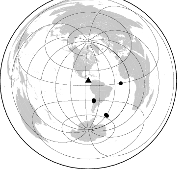
Azimuth Distribution of Events:
Prior Results for this Station
| Study | Thickness | Vp/Vs | Vp | Vs | Poissons Ratio | Extra |
| EARS | 61 km | 1.60 | 6.436 km/s | 4.022 km/s | 0.18 | |
| Crust2.0 | 25 km | 1.77 | 6.436 km/s | 3.632 km/s | 0.27 | LA,very thin continental arc, Cordilleras, 1.0 km seds. |
| Global Maxima | 61 km | 1.60 | 6.436 km/s | 4.022 km/s | 0.18 | amp=0.12167185 |
| Local Maxima 1 | 51 km | 1.72 | 6.436 km/s | 3.753 km/s | 0.24 | amp=0.09759679 |
| Local Maxima 2 | 24 km | 1.76 | 6.436 km/s | 3.657 km/s | 0.26 | amp=0.09141497 |
| Local Maxima 3 | 29 km | 1.71 | 6.436 km/s | 3.775 km/s | 0.24 | amp=0.07539612 |
| Local Maxima 4 | 62 km | 2.10 | 6.436 km/s | 3.068 km/s | 0.35 | amp=0.07187556 |
| Predicted Arrivals for vertical incidence (zero ray parameter) | |
| Ps | 5.69 SECOND |
| PpPs | 24.64 SECOND |
| PsPs/PpSs | 30.33 SECOND |
Events Processed for this Station
Download zip of receiver functions as SAC
Plot maxima for each earthquake.
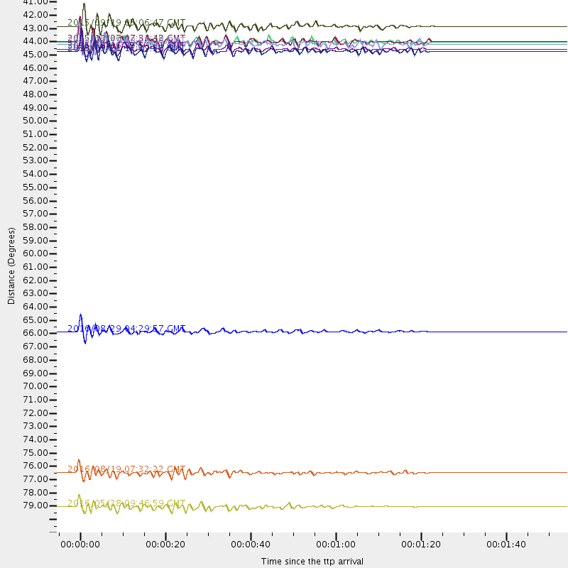
Events Used in the Stack
(9 events)| Radial Match | Distance | Baz | FERegion | Time | Lat/Lon | Depth | Magnitude |
| 92.7884 | 66.4 deg | 94.431 deg | North Of Ascension Island | 2016/08/29 04:29:57 GMT | (-0.0, -17.8) | 10 km | 7.1 MWW, 7.1 MWC, 7.4 MI |
| 90.93385 | 42.9 deg | 164.78 deg | Near Coast Of Central Chile | 2015/09/16 22:54:31 GMT | (-31.6, -71.8) | 12 km | 8.3 MWW, 7.9 MI |
| 88.18799 | 78.1 deg | 152.649 deg | South Georgia Island Region | 2016/08/19 07:32:22 GMT | (-55.3, -31.9) | 10 km | 7.4 MO |
| 85.37748 | 42.3 deg | 164.224 deg | Near Coast Of Central Chile | 2015/11/07 07:31:42 GMT | (-30.9, -71.5) | 36 km | 6.8 MWP, 6.8 MI |
| 85.21728 | 42.3 deg | 163.992 deg | Near Coast Of Central Chile | 2015/09/26 02:51:18 GMT | (-30.8, -71.4) | 38 km | 6.2 MO |
| 84.524574 | 41.0 deg | 164.362 deg | Off Coast Of Central Chile | 2015/09/19 05:06:47 GMT | (-29.7, -72.1) | 10 km | 5.8 MWR |
| 83.56152 | 80.9 deg | 151.685 deg | South Sandwich Islands Region | 2016/05/28 09:46:59 GMT | (-56.2, -26.9) | 73 km | 7.2 MWW, 7.3 MI |
| 83.33465 | 43.1 deg | 164.712 deg | Near Coast Of Central Chile | 2015/09/21 17:39:58 GMT | (-31.7, -71.6) | 25 km | 6.5 MB, 6.5 MI, 6.6 MWW |
| 82.05481 | 42.5 deg | 164.399 deg | Near Coast Of Central Chile | 2015/09/19 09:07:08 GMT | (-31.1, -71.6) | 23 km | 6.1 MWP |
Losers
(26 events)| Radial Match | Distance | Baz | FERegion | Time | Lat/Lon | Depth | Magnitude | Reason |
| 97.02438 | 42.9 deg | 164.971 deg | Near Coast Of Central Chile | 2015/09/16 23:16:05 GMT | (-31.6, -71.9) | 10 km | 6.2 MB | |
| 83.085594 | 92.0 deg | 326.046 deg | Komandorskiye Ostrova Region | 2016/09/05 22:54:04 GMT | (54.3, 168.6) | 10 km | 5.7 MB | |
| 79.28138 | 55.6 deg | 326.114 deg | Vancouver Island, Canada Region | 2015/09/24 13:48:58 GMT | (50.7, -130.2) | 10 km | 5.5 MB, 5.6 MI | |
| 78.70716 | 43.8 deg | 155.426 deg | Santiago Del Estero Prov., Arg. | 2015/11/13 06:04:15 GMT | (-29.9, -64.5) | 11 km | 5.8 MWP | |
| 76.628525 | 80.5 deg | 151.301 deg | South Sandwich Islands Region | 2016/04/19 05:25:39 GMT | (-55.6, -27.2) | 11 km | 5.9 MB | |
| 75.95804 | 43.0 deg | 164.071 deg | Near Coast Of Central Chile | 2015/09/22 07:12:59 GMT | (-31.5, -71.2) | 54 km | 6.1 MWB | |
| 74.76168 | 36.9 deg | 159.769 deg | Near Coast Of Northern Chile | 2015/11/27 21:00:22 GMT | (-24.8, -70.6) | 35 km | 6.2 MWW, 6.2 MWB | |
| 73.7063 | 97.5 deg | 328.171 deg | Kamchatka Peninsula, Russia | 2016/01/30 03:25:10 GMT | (54.0, 158.5) | 161 km | 7.2 MWW, 7.0 MI, 7.2 MWB | |
| 73.18193 | 80.6 deg | 151.921 deg | South Sandwich Islands Region | 2016/02/18 01:07:14 GMT | (-56.2, -27.6) | 119 km | 5.8 MB | |
| 72.24085 | 68.8 deg | 169.686 deg | Drake Passage | 2015/10/20 20:33:12 GMT | (-57.4, -65.9) | 8.9 km | 5.6 MB, 5.5 MWC, 5.5 MWB | |
| 70.07672 | 82.5 deg | 154.574 deg | South Sandwich Islands Region | 2016/09/22 16:07:27 GMT | (-59.5, -27.4) | 10 km | 5.6 MB | |
| 69.91691 | 35.9 deg | 145.66 deg | Southern Bolivia | 2016/01/14 03:25:28 GMT | (-19.8, -63.3) | 582 km | 6.1 MWW, 6.1 MWB | |
| 68.115295 | 82.6 deg | 154.372 deg | South Sandwich Islands Region | 2016/04/24 08:38:00 GMT | (-59.3, -27.0) | 10 km | 5.5 MB | |
| 67.78954 | 36.3 deg | 155.288 deg | Northern Chile | 2015/11/01 15:16:14 GMT | (-23.2, -68.2) | 80 km | 5.8 MB | |
| 67.71251 | 42.1 deg | 164.272 deg | Near Coast Of Central Chile | 2016/01/08 01:12:00 GMT | (-30.7, -71.7) | 31 km | 5.6 MWR | |
| 67.325554 | 42.5 deg | 164.831 deg | Near Coast Of Central Chile | 2015/09/17 04:02:10 GMT | (-31.2, -71.9) | 16 km | 5.7 mwr | |
| 66.43097 | 31.1 deg | 233.209 deg | Central East Pacific Rise | 2015/11/11 06:26:33 GMT | (-9.1, -108.6) | 10 km | 5.6 mwb | |
| 66.17625 | 42.0 deg | 164.385 deg | Near Coast Of Central Chile | 2015/11/21 23:05:29 GMT | (-30.6, -71.8) | 24 km | 5.5 MB | |
| 65.653885 | 38.3 deg | 150.771 deg | Jujuy Province, Argentina | 2015/11/29 18:52:49 GMT | (-23.5, -64.6) | 9.6 km | 5.9 MWP | |
| 65.38131 | 30.7 deg | 233.044 deg | Central East Pacific Rise | 2016/05/05 11:01:46 GMT | (-8.9, -108.2) | 10 km | 5.6 mwb | |
| 61.66048 | 80.6 deg | 151.974 deg | South Sandwich Islands Region | 2015/09/30 16:06:52 GMT | (-56.2, -27.7) | 106 km | 5.7 MB | |
| 52.214355 | 95.1 deg | 249.652 deg | Tonga Islands | 2016/02/15 15:02:33 GMT | (-21.0, -175.5) | 10 km | 5.7 MB | |
| 50.30246 | 92.3 deg | 255.182 deg | Tonga Islands | 2016/07/23 20:09:19 GMT | (-15.1, -173.6) | 10 km | 5.7 MB | |
| 41.50879 | 45.4 deg | 164.268 deg | Chile-Argentina Border Region | 2016/04/14 09:38:44 GMT | (-33.9, -70.4) | 112 km | 5.5 MB | |
| 39.659515 | 38.7 deg | 159.725 deg | Northern Chile | 2016/04/16 06:05:22 GMT | (-26.5, -69.9) | 59 km | 5.3 Mww | |
| 35.82411 | 95.2 deg | 255.813 deg | Fiji Islands Region | 2015/12/01 17:08:25 GMT | (-14.9, -176.6) | 10 km | 5.6 MB |

