
Station OV NARJ - Naranjo
Network: OV - Observatorio Vulcanol?gico y Sismol?gico de Costa Rica
Nearby stations (2 deg radius)
| Station | Name | (Lat, Lon) | Start / End | Elevation |
| NARJ | Naranjo | (9.97, -85.54) | 2012-01-01 / 2599-12-31 | 576 m |
| Crust2 Type: | S1,continental slope, margin, transition 1 km seds. |
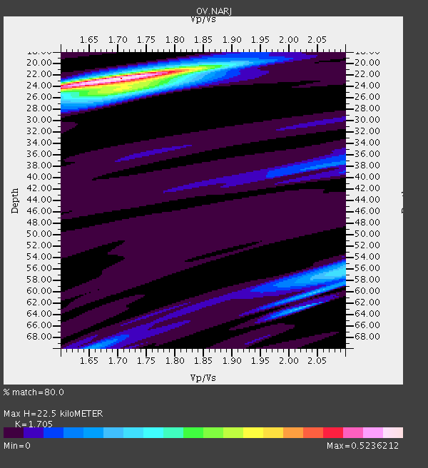
| Thickness Estimate: | 22 km |
| Thickness StdDev: | 0.8 km |
| Vp/Vs Estimate: | 1.71 |
| Vp/Vs StdDev: | 0.06 |
| Vs Estimate: | 3.626 km/s |
| Poisson's Ratio: | 0.24 |
| Peak Value: | 0.52 |
| Assumed Vp: | 6.183 km/s |
| Ps Weight: | 0.33333334 |
| PpPs Weight: | 0.33333334 |
| PsPs Weight: | 0.33333328 |
| Residual Complexity: | 0.423 |
| Nearby stations H: | +- |
| (2.0 deg) Vp/Vs: | +- |
1 with match > 90% ( 7.142857 %) and 2 with match > 80% ( 14.285714 %) out of 14.
Download stack as xyz text file.
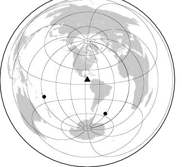
Azimuth Distribution of Events:
Prior Results for this Station
| Study | Thickness | Vp/Vs | Vp | Vs | Poissons Ratio | Extra |
| EARS | 22 km | 1.71 | 6.183 km/s | 3.626 km/s | 0.24 | |
| Crust2.0 | 23 km | 1.81 | 6.183 km/s | 3.422 km/s | 0.28 | S1,continental slope, margin, transition 1 km seds. |
| Global Maxima | 22 km | 1.71 | 6.183 km/s | 3.626 km/s | 0.24 | amp=0.5236212 |
| Local Maxima 1 | 24 km | 1.72 | 6.183 km/s | 3.595 km/s | 0.24 | amp=0.21090363 |
| Local Maxima 2 | 56 km | 2.10 | 6.183 km/s | 2.948 km/s | 0.35 | amp=0.17336123 |
| Local Maxima 3 | 70 km | 1.65 | 6.183 km/s | 3.741 km/s | 0.21 | amp=0.11845406 |
| Local Maxima 4 | 62 km | 2.03 | 6.183 km/s | 3.049 km/s | 0.34 | amp=0.11589849 |
| Predicted Arrivals for vertical incidence (zero ray parameter) | |
| Ps | 2.57 SECOND |
| PpPs | 9.84 SECOND |
| PsPs/PpSs | 12.41 SECOND |
Events Processed for this Station
Download zip of receiver functions as SAC
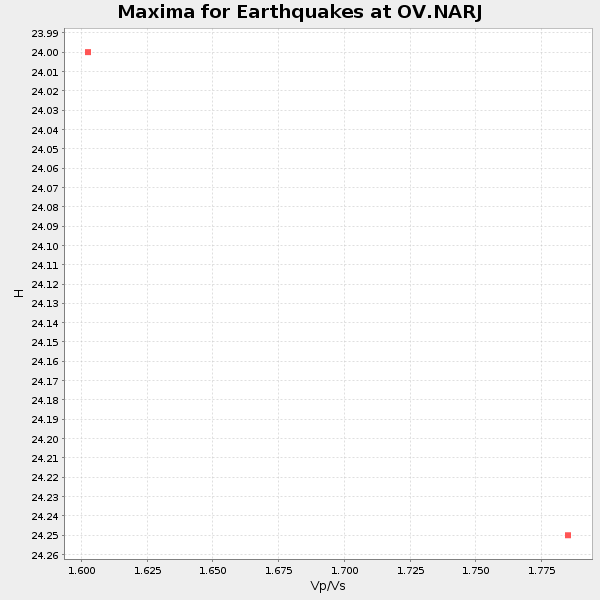
Plot maxima for each earthquake.
Events Used in the Stack
(2 events)| Radial Match | Distance | Baz | FERegion | Time | Lat/Lon | Depth | Magnitude |
| 91.67112 | 78.9 deg | 152.054 deg | South Georgia Island Region | 2016/08/19 07:32:22 GMT | (-55.3, -31.9) | 10 km | 7.4 MO |
| 87.48921 | 95.6 deg | 248.597 deg | South Of Fiji Islands | 2016/11/16 20:26:15 GMT | (-22.1, -177.6) | 305 km | 5.5 MB |
Losers
(12 events)| Radial Match | Distance | Baz | FERegion | Time | Lat/Lon | Depth | Magnitude | Reason |
| 97.65697 | 57.0 deg | 95.417 deg | Central Mid-Atlantic Ridge | 2016/07/24 14:10:51 GMT | (0.9, -29.0) | 10 km | 5.7 mwb | |
| 89.56096 | 95.5 deg | 245.483 deg | South Of Fiji Islands | 2016/08/12 03:29:27 GMT | (-25.2, -177.0) | 75 km | 6.1 MO | |
| 78.30006 | 96.9 deg | 238.244 deg | South Of Kermadec Islands | 2016/09/25 04:28:37 GMT | (-32.5, -177.5) | 10 km | 5.9 MO | |
| 77.163605 | 78.9 deg | 151.939 deg | South Georgia Island Region | 2016/08/21 03:45:23 GMT | (-55.3, -31.8) | 10 km | 6.4 MWP | |
| 74.99741 | 44.4 deg | 159.392 deg | San Juan Province, Argentina | 2016/11/20 20:57:43 GMT | (-31.6, -68.8) | 116 km | 6.4 MWP, 6.5 MWB | |
| 74.32366 | 79.3 deg | 151.703 deg | South Sandwich Islands Region | 2016/09/02 01:57:53 GMT | (-55.3, -31.0) | 31 km | 5.6 MB | |
| 72.08148 | 72.8 deg | 201.079 deg | Southern East Pacific Rise | 2016/08/18 18:09:45 GMT | (-56.0, -123.2) | 9.5 km | 5.5 MB | |
| 71.75336 | 46.9 deg | 163.616 deg | Chile-Argentina Border Region | 2016/11/04 16:20:43 GMT | (-35.1, -71.0) | 91 km | 6.4 MWP, 6.4 MWW | |
| 64.15032 | 48.5 deg | 200.2 deg | Southeast Of Easter Island | 2016/10/13 20:40:51 GMT | (-35.5, -104.0) | 10 km | 5.0 mb | |
| 60.06386 | 92.0 deg | 254.67 deg | Tonga Islands | 2016/10/26 05:19:50 GMT | (-15.5, -174.9) | 10 km | 6.1 MWW, 6.1 MWC | |
| 51.46265 | 45.3 deg | 155.96 deg | Cordoba Province, Argentina | 2016/09/09 00:03:43 GMT | (-31.4, -65.7) | 151 km | 5.6 MWR | |
| 48.532894 | 45.2 deg | 164.68 deg | Off Coast Of Central Chile | 2016/10/27 20:32:55 GMT | (-33.8, -72.5) | 15 km | 5.9 MWB |

