
Station OV VACR - Volcan Arenal
Network: OV - Observatorio Vulcanol?gico y Sismol?gico de Costa Rica
Nearby stations (2 deg radius)

| Station | Name | (Lat, Lon) | Start / End | Elevation |
| VACR | Volcan Arenal | (10.47, -84.68) | 2015-09-22 / 2599-12-31 | 370 m |
| Crust2 Type: | L3,continental arc, Southern Andes, 0.2 km seds. |
| Thickness Estimate: | 32 km |
| Thickness StdDev: | 16 km |
| Vp/Vs Estimate: | 1.68 |
| Vp/Vs StdDev: | 0.10 |
| Vs Estimate: | 3.927 km/s |
| Poisson's Ratio: | 0.23 |
| Peak Value: | 0.06 |
| Assumed Vp: | 6.597 km/s |
| Ps Weight: | 0.33333334 |
| PpPs Weight: | 0.33333334 |
| PsPs Weight: | 0.33333328 |
| Residual Complexity: | 0.758 |
| Nearby stations H: | +- |
| (2.0 deg) Vp/Vs: | +- |
0 with match > 90% ( 0.0 %) and 3 with match > 80% ( 6.0 %) out of 50.
Download stack as xyz text file.
Azimuth Distribution of Events:
Prior Results for this Station
| Study | Thickness | Vp/Vs | Vp | Vs | Poissons Ratio | Extra |
| EARS | 32 km | 1.68 | 6.597 km/s | 3.927 km/s | 0.23 | |
| Crust2.0 | 40 km | 1.77 | 6.597 km/s | 3.723 km/s | 0.27 | L3,continental arc, Southern Andes, 0.2 km seds. |
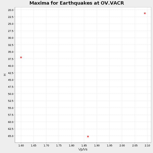
| Global Maxima | 32 km | 1.68 | 6.597 km/s | 3.927 km/s | 0.23 | amp=0.062432673 |
| Local Maxima 1 | 65 km | 1.87 | 6.597 km/s | 3.528 km/s | 0.30 | amp=0.04841677 |
| Local Maxima 2 | 45 km | 1.60 | 6.597 km/s | 4.123 km/s | 0.18 | amp=0.036374602 |
| Local Maxima 3 | 25 km | 1.79 | 6.597 km/s | 3.691 km/s | 0.27 | amp=0.03354221 |
| Local Maxima 4 | 68 km | 1.86 | 6.597 km/s | 3.557 km/s | 0.30 | amp=0.027987259 |
| Predicted Arrivals for vertical incidence (zero ray parameter) | |
| Ps | 3.32 SECOND |
| PpPs | 13.10 SECOND |
| PsPs/PpSs | 16.42 SECOND |
Events Processed for this Station
Download zip of receiver functions as SAC
Plot maxima for each earthquake.
Events Used in the Stack
(3 events)| Radial Match | Distance | Baz | FERegion | Time | Lat/Lon | Depth | Magnitude |
| 83.87151 | 38.8 deg | 159.661 deg | Near Coast Of Northern Chile | 2016/07/25 17:26:49 GMT | (-26.1, -70.6) | 68 km | 6.2 MB |
| 83.79009 | 37.4 deg | 153.692 deg | Chile-Argentina Border Region | 2017/04/15 08:19:41 GMT | (-23.2, -67.7) | 135 km | 6.2 Mww |
| 82.37306 | 47.1 deg | 164.662 deg | Chile-Argentina Border Region | 2016/11/04 16:20:43 GMT | (-35.1, -71.0) | 91 km | 6.4 MWP, 6.4 MWW |
Losers
(47 events)| Radial Match | Distance | Baz | FERegion | Time | Lat/Lon | Depth | Magnitude | Reason |
| 95.25342 | 96.4 deg | 242.852 deg | Kermadec Islands Region | 2016/07/13 13:04:25 GMT | (-27.9, -176.5) | 10 km | 5.7 MB | |
| 92.02648 | 48.3 deg | 194.879 deg | Southeast Of Easter Island | 2017/04/20 22:04:14 GMT | (-36.3, -98.4) | 10 km | 5.5 Mwb | |
| 84.95881 | 78.9 deg | 152.4 deg | South Georgia Island Region | 2016/08/19 07:32:22 GMT | (-55.3, -31.9) | 10 km | 7.4 MO | |
| 83.968445 | 81.8 deg | 151.464 deg | South Sandwich Islands Region | 2016/05/28 09:46:59 GMT | (-56.2, -26.9) | 73 km | 7.2 MWW, 7.3 MI | |
| 81.92105 | 54.3 deg | 170.863 deg | Southern Chile | 2016/12/25 14:22:28 GMT | (-43.3, -74.5) | 15 km | 7.7 Mi | |
| 80.705246 | 44.6 deg | 160.537 deg | San Juan Province, Argentina | 2016/11/20 20:57:43 GMT | (-31.6, -68.8) | 116 km | 6.4 MWP, 6.5 MWB | |
| 77.996635 | 37.4 deg | 150.815 deg | Jujuy Province, Argentina | 2016/08/04 14:15:11 GMT | (-22.4, -66.0) | 258 km | 6.0 MO | |
| 75.35376 | 81.3 deg | 151.077 deg | South Sandwich Islands Region | 2016/04/19 05:25:39 GMT | (-55.6, -27.2) | 11 km | 5.9 MB | |
| 73.584625 | 44.9 deg | 164.854 deg | Off Coast Of Central Chile | 2017/04/24 21:38:24 GMT | (-33.0, -72.0) | 33 km | 6.7 Mi | |
| 72.54499 | 91.5 deg | 254.901 deg | Tonga Islands | 2016/02/07 02:03:40 GMT | (-15.2, -173.4) | 51 km | 5.4 MB, 5.8 MWB, 5.9 MWW, 6.0 MWC | |
| 71.75493 | 88.6 deg | 46.789 deg | Central Italy | 2016/10/30 06:40:19 GMT | (42.9, 13.1) | 10 km | 6.6 MWW, 6.6 MWR | |
| 71.35993 | 82.5 deg | 151.129 deg | South Sandwich Islands Region | 2017/05/10 23:23:39 GMT | (-56.3, -25.5) | 41 km | 6.8 Mi | |
| 70.82101 | 37.1 deg | 154.426 deg | Northern Chile | 2015/11/01 15:16:14 GMT | (-23.2, -68.2) | 80 km | 5.8 MB | |
| 70.06378 | 36.7 deg | 144.975 deg | Southern Bolivia | 2016/01/14 03:25:28 GMT | (-19.8, -63.3) | 582 km | 6.1 MWW, 6.1 MWB | |
| 69.81143 | 43.0 deg | 163.142 deg | Near Coast Of Central Chile | 2015/09/26 02:51:18 GMT | (-30.8, -71.4) | 38 km | 6.2 MO | |
| 68.82067 | 42.4 deg | 163.233 deg | Near Coast Of Central Chile | 2015/10/05 16:33:26 GMT | (-30.3, -71.7) | 35 km | 6.0 MB | |
| 68.79346 | 62.5 deg | 333.406 deg | Southeastern Alaska | 2017/05/01 12:31:53 GMT | (59.9, -136.6) | 0.1 km | 6.5 Ml | |
| 68.57489 | 42.8 deg | 163.332 deg | Near Coast Of Central Chile | 2016/02/10 00:33:05 GMT | (-30.6, -71.6) | 32 km | 6.3 MWB | |
| 67.95284 | 83.3 deg | 154.361 deg | South Sandwich Islands Region | 2016/09/22 16:07:27 GMT | (-59.5, -27.4) | 10 km | 5.6 MB | |
| 66.97499 | 96.7 deg | 327.969 deg | Kamchatka Peninsula, Russia | 2016/01/30 03:25:10 GMT | (54.0, 158.5) | 161 km | 7.2 MWW, 7.0 MI, 7.2 MWB | |
| 66.83285 | 43.0 deg | 163.372 deg | Near Coast Of Central Chile | 2015/11/07 07:31:42 GMT | (-30.9, -71.5) | 36 km | 6.8 MWP, 6.8 MI | |
| 65.28693 | 91.7 deg | 255.059 deg | Tonga Islands | 2016/07/23 20:09:19 GMT | (-15.1, -173.6) | 10 km | 5.7 MB | |
| 64.379326 | 98.0 deg | 240.603 deg | Kermadec Islands, New Zealand | 2016/05/30 07:14:16 GMT | (-30.4, -177.9) | 32 km | 5.7 MWB | |
| 63.64225 | 39.4 deg | 158.848 deg | Northern Chile | 2016/04/16 06:05:22 GMT | (-26.5, -69.9) | 59 km | 5.3 Mww | |
| 63.528885 | 93.2 deg | 329.529 deg | Near East Coast Of Kamchatka | 2017/03/29 04:09:24 GMT | (56.9, 162.7) | 23 km | 6.6 Mww | |
| 62.734795 | 54.4 deg | 325.811 deg | Vancouver Island, Canada Region | 2017/01/07 03:13:54 GMT | (50.3, -130.1) | 10 km | 5.7 Mwp | |
| 62.701855 | 79.0 deg | 152.285 deg | South Georgia Island Region | 2016/08/21 03:45:23 GMT | (-55.3, -31.8) | 10 km | 6.4 MWP | |
| 62.228645 | 93.5 deg | 245.823 deg | South Of Tonga Islands | 2015/11/24 02:46:05 GMT | (-24.5, -173.8) | 15 km | 5.5 mwc | |
| 62.17093 | 39.1 deg | 150.036 deg | Jujuy Province, Argentina | 2015/11/29 18:52:49 GMT | (-23.5, -64.6) | 9.6 km | 5.9 MWP | |
| 60.07786 | 36.1 deg | 156.504 deg | Northern Chile | 2017/01/11 21:58:17 GMT | (-22.8, -69.9) | 69 km | 5.9 Mww | |
| 59.875668 | 79.4 deg | 152.042 deg | South Sandwich Islands Region | 2016/09/02 01:57:53 GMT | (-55.3, -31.0) | 31 km | 5.6 MB | |
| 59.14048 | 42.9 deg | 163.042 deg | Near Coast Of Central Chile | 2015/11/07 10:53:38 GMT | (-30.7, -71.3) | 3.8 km | 5.9 MB | |
| 58.49366 | 41.9 deg | 156.748 deg | La Rioja Province, Argentina | 2016/11/13 01:01:51 GMT | (-28.1, -67.3) | 121 km | 5.7 MB | |
| 57.949333 | 46.1 deg | 163.487 deg | Chile-Argentina Border Region | 2016/04/14 09:38:44 GMT | (-33.9, -70.4) | 112 km | 5.5 MB | |
| 57.261578 | 81.5 deg | 151.71 deg | South Sandwich Islands Region | 2016/07/31 11:33:20 GMT | (-56.3, -27.5) | 98 km | 5.9 MWW, 5.9 MWC, 5.9 MWB | |
| 56.9106 | 38.5 deg | 153.703 deg | Chile-Argentina Border Region | 2016/06/18 17:29:44 GMT | (-24.2, -67.1) | 167 km | 5.5 MB | |
| 55.523464 | 44.6 deg | 154.727 deg | Santiago Del Estero Prov., Arg. | 2015/11/13 06:04:15 GMT | (-29.9, -64.5) | 11 km | 5.8 MWP | |
| 54.930035 | 81.5 deg | 320.865 deg | Andreanof Islands, Aleutian Is. | 2016/03/12 18:06:45 GMT | (51.6, -174.0) | 19 km | 6.3 MWW, 6.1 MB, 6.2 MWB, 6.3 MWC, 6.4 MWC, 6.4 MI | |
| 54.555832 | 42.8 deg | 163.036 deg | Near Coast Of Central Chile | 2015/12/19 19:25:04 GMT | (-30.6, -71.4) | 46 km | 5.8 MWR | |
| 54.36544 | 47.2 deg | 316.518 deg | Off Coast Of Northern California | 2016/12/08 14:49:46 GMT | (40.5, -126.2) | 12 km | 6.5 Mwb | |
| 53.941704 | 81.4 deg | 151.749 deg | South Sandwich Islands Region | 2015/09/30 16:06:52 GMT | (-56.2, -27.7) | 106 km | 5.7 MB | |
| 53.074043 | 42.8 deg | 163.413 deg | Near Coast Of Central Chile | 2016/01/08 01:12:00 GMT | (-30.7, -71.7) | 31 km | 5.6 MWR | |
| 51.64523 | 49.2 deg | 319.545 deg | Off Coast Of Oregon | 2016/11/28 04:34:44 GMT | (43.4, -127.0) | 28 km | 5.5 MWW, 5.4 MWR | |
| 49.233894 | 88.7 deg | 47.013 deg | Central Italy | 2017/01/18 10:25:25 GMT | (42.6, 13.2) | 10 km | 5.6 Mww | |
| 48.43936 | 83.4 deg | 154.161 deg | South Sandwich Islands Region | 2016/04/24 08:38:00 GMT | (-59.3, -27.0) | 10 km | 5.5 MB | |
| 43.443398 | 44.9 deg | 164.884 deg | Off Coast Of Central Chile | 2017/04/24 21:46:04 GMT | (-33.0, -72.0) | 22 km | 5.0 mb | |
| 29.832424 | 54.4 deg | 170.806 deg | Southern Chile | 2017/01/03 21:19:07 GMT | (-43.3, -74.4) | 11 km | 5.5 Mwr |

