
Station OV VIRE - Volcan irazu hacienda Retes
Network: OV - Observatorio Vulcanol?gico y Sismol?gico de Costa Rica
Nearby stations (2 deg radius)
| Station | Name | (Lat, Lon) | Start / End | Elevation |
| VIRE | Volcan irazu hacienda Retes | (9.97, -83.90) | 2012-05-01 / 2599-12-31 | 2971 m |
| Crust2 Type: | LA,very thin continental arc, Cordilleras, 1.0 km seds. |
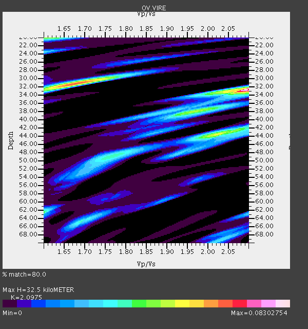
| Thickness Estimate: | 32 km |
| Thickness StdDev: | 7.1 km |
| Vp/Vs Estimate: | 2.10 |
| Vp/Vs StdDev: | 0.16 |
| Vs Estimate: | 3.068 km/s |
| Poisson's Ratio: | 0.35 |
| Peak Value: | 0.08 |
| Assumed Vp: | 6.436 km/s |
| Ps Weight: | 0.33333334 |
| PpPs Weight: | 0.33333334 |
| PsPs Weight: | 0.33333328 |
| Residual Complexity: | 0.828 |
| Nearby stations H: | +- |
| (2.0 deg) Vp/Vs: | +- |
1 with match > 90% ( 4.7619047 %) and 5 with match > 80% ( 23.809525 %) out of 21.
Download stack as xyz text file.
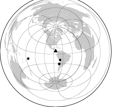
Azimuth Distribution of Events:
Prior Results for this Station
| Study | Thickness | Vp/Vs | Vp | Vs | Poissons Ratio | Extra |
| EARS | 32 km | 2.10 | 6.436 km/s | 3.068 km/s | 0.35 | |
| Crust2.0 | 25 km | 1.77 | 6.436 km/s | 3.632 km/s | 0.27 | LA,very thin continental arc, Cordilleras, 1.0 km seds. |
| Global Maxima | 32 km | 2.10 | 6.436 km/s | 3.068 km/s | 0.35 | amp=0.08302754 |
| Local Maxima 1 | 31 km | 1.68 | 6.436 km/s | 3.825 km/s | 0.23 | amp=0.064656414 |
| Local Maxima 2 | 44 km | 2.02 | 6.436 km/s | 3.186 km/s | 0.34 | amp=0.050804157 |
| Local Maxima 3 | 20 km | 1.61 | 6.436 km/s | 4.004 km/s | 0.18 | amp=0.044767164 |
| Local Maxima 4 | 62 km | 1.60 | 6.436 km/s | 4.022 km/s | 0.18 | amp=0.03773397 |
| Predicted Arrivals for vertical incidence (zero ray parameter) | |
| Ps | 5.54 SECOND |
| PpPs | 15.64 SECOND |
| PsPs/PpSs | 21.18 SECOND |
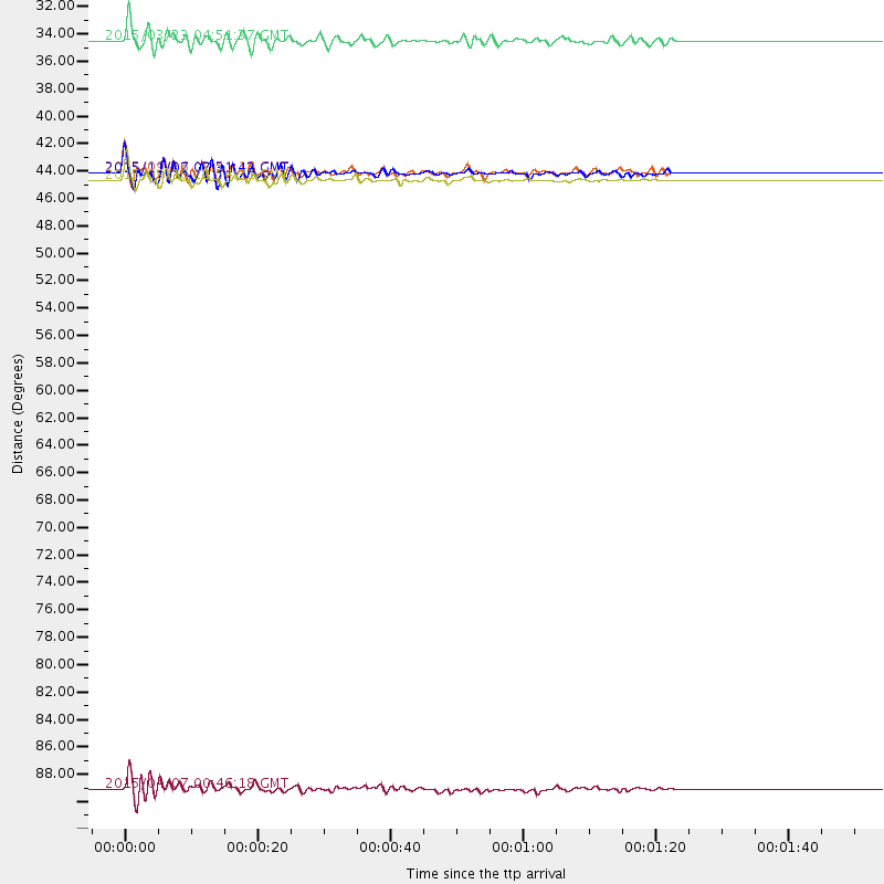
Events Processed for this Station
Download zip of receiver functions as SAC
Plot maxima for each earthquake.
Events Used in the Stack
(5 events)| Radial Match | Distance | Baz | FERegion | Time | Lat/Lon | Depth | Magnitude |
| 92.04458 | 42.9 deg | 164.711 deg | Near Coast Of Central Chile | 2015/09/16 22:54:31 GMT | (-31.6, -71.8) | 12 km | 8.3 MWW, 7.9 MI |
| 83.95337 | 91.9 deg | 255.005 deg | Tonga Islands | 2015/04/07 00:46:18 GMT | (-15.2, -173.2) | 10 km | 5.8 MB |
| 82.731514 | 42.3 deg | 163.921 deg | Near Coast Of Central Chile | 2015/09/26 02:51:18 GMT | (-30.8, -71.4) | 38 km | 6.2 MO |
| 80.90951 | 42.3 deg | 164.154 deg | Near Coast Of Central Chile | 2015/11/07 07:31:42 GMT | (-30.9, -71.5) | 36 km | 6.8 MWP, 6.8 MI |
| 80.518875 | 31.7 deg | 153.007 deg | Northern Chile | 2015/03/23 04:51:37 GMT | (-18.4, -69.4) | 128 km | 6.1 MWP, 6.1 MO |
Losers
(16 events)| Radial Match | Distance | Baz | FERegion | Time | Lat/Lon | Depth | Magnitude | Reason |
| 95.92988 | 42.9 deg | 164.902 deg | Near Coast Of Central Chile | 2015/09/16 23:16:05 GMT | (-31.6, -71.9) | 10 km | 6.2 MB | |
| 91.504005 | 42.1 deg | 164.383 deg | Near Coast Of Central Chile | 2015/09/16 23:28:23 GMT | (-30.7, -71.8) | 21 km | 5.5 MB | |
| 77.76739 | 42.5 deg | 164.329 deg | Near Coast Of Central Chile | 2015/09/19 09:07:08 GMT | (-31.1, -71.6) | 23 km | 6.1 MWP | |
| 74.78702 | 43.8 deg | 155.36 deg | Santiago Del Estero Prov., Arg. | 2015/11/13 06:04:15 GMT | (-29.9, -64.5) | 11 km | 5.8 MWP | |
| 74.448746 | 42.6 deg | 164.341 deg | Near Coast Of Central Chile | 2015/09/17 01:41:09 GMT | (-31.2, -71.6) | 37 km | 5.6 MB | |
| 72.96371 | 36.9 deg | 153.047 deg | Jujuy Province, Argentina | 2015/02/11 18:57:22 GMT | (-23.1, -66.7) | 223 km | 6.7 MWW, 6.7 MWC, 6.7 MWB, 6.9 MI | |
| 68.31018 | 79.4 deg | 321.225 deg | Fox Islands, Aleutian Islands | 2015/07/29 16:05:02 GMT | (52.0, -169.3) | 26 km | 5.3 MW | |
| 67.763115 | 80.6 deg | 151.956 deg | South Sandwich Islands Region | 2015/09/30 16:06:52 GMT | (-56.2, -27.7) | 106 km | 5.7 MB | |
| 67.44693 | 36.4 deg | 155.204 deg | Northern Chile | 2015/11/01 15:16:14 GMT | (-23.2, -68.2) | 80 km | 5.8 MB | |
| 66.51354 | 97.2 deg | 327.182 deg | Near East Coast Of Kamchatka | 2015/09/17 08:58:44 GMT | (53.3, 159.7) | 69 km | 5.5 MB | |
| 61.740215 | 82.2 deg | 208.034 deg | Pacific-Antarctic Ridge | 2015/09/26 21:40:35 GMT | (-57.1, -142.4) | 10 km | 6.0 MWC, 5.9 MWB, 6.0 MWC | |
| 59.444786 | 72.2 deg | 326.427 deg | Alaska Peninsula | 2015/05/29 07:00:08 GMT | (56.7, -156.5) | 62 km | 6.8 MWP, 6.8 MI | |
| 49.614952 | 93.1 deg | 252.702 deg | Tonga Islands | 2015/04/04 05:27:08 GMT | (-17.7, -174.0) | 35 km | 4.6 mb | |
| 45.41848 | 83.1 deg | 153.277 deg | South Sandwich Islands Region | 2015/05/26 23:51:29 GMT | (-58.7, -25.2) | 28 km | 5.6 MW, 5.3 mb, 5.2 MS | |
| 41.863987 | 82.1 deg | 152.477 deg | South Sandwich Islands Region | 2015/08/26 13:51:39 GMT | (-57.5, -26.0) | 64 km | 5.7 MB | |
| 41.258713 | 95.8 deg | 253.428 deg | Fiji Islands Region | 2015/04/03 17:44:02 GMT | (-17.4, -177.0) | 379 km | 5.8 MW |

