
Station PF RVL - Station Sismologique de Rivals Ouest
Network: PF - Volcanologic Network of Piton de Fournaise-OVPF
Nearby stations (2 deg radius)
| Station | Name | (Lat, Lon) | Start / End | Elevation |
| RVL | Station Sismologique de Rivals Ouest | (-21.26, 55.70) | 2011-01-01 / 2599-12-31 | 2110 m |
| Crust2 Type: | B1,melt affected o.c. and oceanic plateaus, 0.5 km seds. |
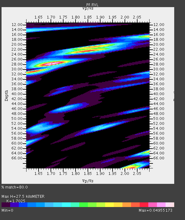
| Thickness Estimate: | 28 km |
| Thickness StdDev: | 18 km |
| Vp/Vs Estimate: | 1.70 |
| Vp/Vs StdDev: | 0.14 |
| Vs Estimate: | 2.778 km/s |
| Poisson's Ratio: | 0.24 |
| Peak Value: | 0.05 |
| Assumed Vp: | 4.73 km/s |
| Ps Weight: | 0.33333334 |
| PpPs Weight: | 0.33333334 |
| PsPs Weight: | 0.33333328 |
| Residual Complexity: | 0.718 |
| Nearby stations H: | 24 km +- 7.6 km |
| (2.0 deg) Vp/Vs: | 1.76 +- 0.20 |
1 with match > 90% ( 3.4482758 %) and 4 with match > 80% ( 13.793103 %) out of 29.
Download stack as xyz text file.
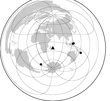
Azimuth Distribution of Events:
Prior Results for this Station
| Study | Thickness | Vp/Vs | Vp | Vs | Poissons Ratio | Extra |
| EARS | 28 km | 1.70 | 4.73 km/s | 2.778 km/s | 0.24 | |
| Crust2.0 | 16 km | 2.06 | 4.73 km/s | 2.3 km/s | 0.35 | B1,melt affected o.c. and oceanic plateaus, 0.5 km seds. |
| Global Maxima | 28 km | 1.70 | 4.73 km/s | 2.778 km/s | 0.24 | amp=0.04955173 |
| Local Maxima 1 | 70 km | 2.03 | 4.73 km/s | 2.333 km/s | 0.34 | amp=0.039809644 |
| Local Maxima 2 | 20 km | 1.88 | 4.73 km/s | 2.509 km/s | 0.30 | amp=0.035356693 |
| Local Maxima 3 | 63 km | 2.10 | 4.73 km/s | 2.258 km/s | 0.35 | amp=0.03218742 |
| Local Maxima 4 | 31 km | 1.62 | 4.73 km/s | 2.915 km/s | 0.19 | amp=0.029491158 |
| Predicted Arrivals for vertical incidence (zero ray parameter) | |
| Ps | 4.08 SECOND |
| PpPs | 15.71 SECOND |
| PsPs/PpSs | 19.80 SECOND |
Events Processed for this Station
Download zip of receiver functions as SAC
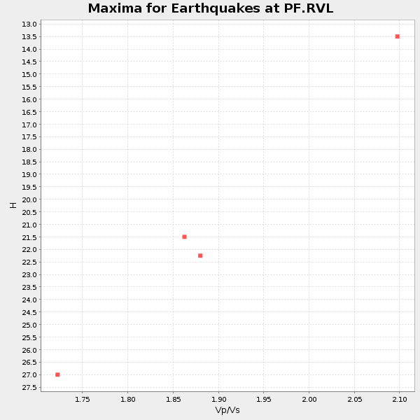
Plot maxima for each earthquake.
Events Used in the Stack
(4 events)| Radial Match | Distance | Baz | FERegion | Time | Lat/Lon | Depth | Magnitude |
| 93.39882 | 96.5 deg | 99.206 deg | Solomon Islands | 2017/01/22 04:30:23 GMT | (-6.2, 155.1) | 136 km | 7.9 mww |
| 89.35752 | 68.5 deg | 216.549 deg | South Sandwich Islands Region | 2016/05/28 09:46:59 GMT | (-56.2, -26.9) | 73 km | 7.2 MWW, 7.3 MI |
| 89.10575 | 70.4 deg | 77.007 deg | Celebes Sea | 2017/01/10 06:13:48 GMT | (4.4, 122.7) | 622 km | 6.9 Mi |
| 86.46133 | 73.0 deg | 77.007 deg | Mindanao, Philippines | 2017/04/28 20:23:18 GMT | (5.5, 125.1) | 10 km | 7.2 Mi |
Losers
(25 events)| Radial Match | Distance | Baz | FERegion | Time | Lat/Lon | Depth | Magnitude | Reason |
| 90.963165 | 95.7 deg | 96.956 deg | New Ireland Region, P.N.G. | 2016/12/17 11:22:39 GMT | (-4.4, 153.5) | 83 km | 5.6 mb | |
| 85.7923 | 94.8 deg | 138.894 deg | South Island, New Zealand | 2016/11/13 13:31:26 GMT | (-42.3, 173.7) | 8.3 km | 6.2 MWW | |
| 84.85558 | 61.6 deg | 88.952 deg | Sumbawa Region, Indonesia | 2016/12/29 22:30:18 GMT | (-9.1, 118.6) | 72 km | 6.2 Mwp | |
| 81.91328 | 96.4 deg | 72.705 deg | Mariana Islands | 2016/07/29 21:18:25 GMT | (18.5, 145.5) | 212 km | 7.7 MWW, 7.7 MWB, 7.7 MI | |
| 79.790436 | 56.6 deg | 44.679 deg | Myanmar | 2016/08/24 10:34:55 GMT | (20.9, 94.6) | 84 km | 6.8 MO | |
| 79.62704 | 70.7 deg | 90.711 deg | Banda Sea | 2016/12/21 00:17:15 GMT | (-7.5, 127.9) | 152 km | 6.7 Mww | |
| 79.375 | 53.4 deg | 79.933 deg | Java Sea | 2016/10/19 00:26:01 GMT | (-4.9, 108.2) | 614 km | 6.6 MWW, 6.6 MWC, 6.7 MWB | |
| 78.10507 | 95.7 deg | 97.015 deg | New Ireland Region, P.N.G. | 2016/12/17 10:51:11 GMT | (-4.5, 153.6) | 73 km | 8.0 Mi | |
| 73.93286 | 72.0 deg | 81.28 deg | Northern Molucca Sea | 2016/10/27 08:17:49 GMT | (1.3, 125.8) | 56 km | 5.9 MB, 5.8 MWB | |
| 70.225235 | 47.7 deg | 72.62 deg | Southern Sumatra, Indonesia | 2016/06/01 22:56:00 GMT | (-2.1, 100.7) | 50 km | 6.6 MWW, 6.4 MWB, 6.6 MWC, 6.7 MWC | |
| 68.46995 | 72.0 deg | 326.802 deg | Tyrrhenian Sea | 2016/10/28 20:02:48 GMT | (39.3, 13.5) | 448 km | 5.8 MWW, 5.8 MWB | |
| 66.845245 | 90.8 deg | 96.747 deg | New Britain Region, P.N.G. | 2016/10/17 06:14:58 GMT | (-6.1, 148.9) | 35 km | 6.9 MO | |
| 66.18882 | 66.6 deg | 88.89 deg | Banda Sea | 2016/12/05 01:13:04 GMT | (-7.3, 123.4) | 526 km | 6.3 Mww | |
| 65.9259 | 94.7 deg | 76.578 deg | Mariana Islands | 2017/03/13 08:49:06 GMT | (14.3, 145.3) | 101 km | 5.5 Mi | |
| 64.46464 | 70.8 deg | 82.24 deg | Northern Molucca Sea | 2017/01/13 16:39:25 GMT | (0.0, 125.1) | 46 km | 5.7 mb | |
| 63.990265 | 65.8 deg | 88.512 deg | Flores Sea | 2016/08/23 19:39:44 GMT | (-7.3, 122.5) | 528 km | 6.0 MB | |
| 60.2076 | 74.9 deg | 328.958 deg | Central Italy | 2016/10/30 06:40:19 GMT | (42.9, 13.1) | 10 km | 6.6 MWW, 6.6 MWR | |
| 58.038734 | 84.6 deg | 89.973 deg | Irian Jaya Region, Indonesia | 2016/09/24 11:04:30 GMT | (-1.9, 140.6) | 10 km | 5.6 MB | |
| 57.55974 | 85.5 deg | 58.397 deg | Ryukyu Islands, Japan | 2016/09/26 05:19:58 GMT | (27.5, 128.6) | 40 km | 6.0 MB | |
| 53.246178 | 69.6 deg | 86.987 deg | Banda Sea | 2016/06/05 16:25:33 GMT | (-4.6, 125.6) | 429 km | 6.3 MWB | |
| 51.72642 | 74.9 deg | 77.671 deg | Philippine Islands Region | 2017/04/11 14:42:16 GMT | (5.7, 127.1) | 9.6 km | 5.6 mb | |
| 51.287582 | 90.5 deg | 96.721 deg | New Britain Region, P.N.G. | 2016/11/01 19:03:28 GMT | (-6.1, 148.6) | 35 km | 5.9 MWB | |
| 50.553757 | 96.1 deg | 98.454 deg | Solomon Islands | 2016/12/10 16:24:36 GMT | (-5.7, 154.5) | 157 km | 6.1 Mwp | |
| 43.70276 | 56.9 deg | 4.594 deg | Northern And Central Iran | 2017/04/05 06:09:12 GMT | (35.8, 60.4) | 13 km | 6.1 Mww | |
| 39.76015 | 72.5 deg | 81.513 deg | Northern Molucca Sea | 2016/06/07 19:15:15 GMT | (1.3, 126.3) | 31 km | 6.3 MWW, 6.2 MWB, 6.3 MWC, 6.4 MWC, 6.5 MI, 6.6 MI |

