
Station PO DRWO - Darlington West, ON, CANADA
Network: PO - Portable Observatories for Lithospheric Analysis and Research Investigating Seis
Nearby stations (2 deg radius)
| Station | Name | (Lat, Lon) | Start / End | Elevation |
| DRWO | Darlington West, ON, CANADA | (43.87, -78.73) | 2007-06-20 / 2599-12-31 | 59 m |
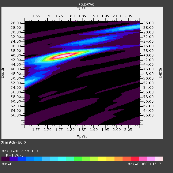
| Crust2 Type: | Q2,orogen/39km no ice, Appalachians, North Andes, 0.5 km seds. |
| Thickness Estimate: | 40 km |
| Thickness StdDev: | 0.3 km |
| Vp/Vs Estimate: | 1.77 |
| Vp/Vs StdDev: | 0.01 |
| Vs Estimate: | 3.632 km/s |
| Poisson's Ratio: | 0.26 |
| Peak Value: | 0.06 |
| Assumed Vp: | 6.419 km/s |
| Ps Weight: | 0.33333334 |
| PpPs Weight: | 0.33333334 |
| PsPs Weight: | 0.33333328 |
| Residual Complexity: | 0.331 |
| Nearby stations H: | 40 km +- 0.0 km |
| (2.0 deg) Vp/Vs: | 1.77 +- 0.00 |
8 with match > 90% ( 36.363636 %) and 13 with match > 80% ( 59.090908 %) out of 22.
Download stack as xyz text file.
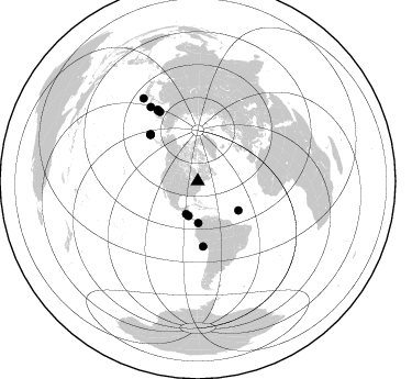
Azimuth Distribution of Events:
Prior Results for this Station
| Study | Thickness | Vp/Vs | Vp | Vs | Poissons Ratio | Extra |
| EARS | 40 km | 1.77 | 6.419 km/s | 3.632 km/s | 0.26 | |
| Crust2.0 | 39 km | 1.75 | 6.419 km/s | 3.659 km/s | 0.26 | Q2,orogen/39km no ice, Appalachians, North Andes, 0.5 km seds. |
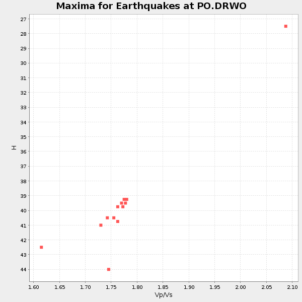
| Global Maxima | 40 km | 1.77 | 6.419 km/s | 3.632 km/s | 0.26 | amp=0.060101517 |
| Local Maxima 1 | 52 km | 1.60 | 6.419 km/s | 4.012 km/s | 0.18 | amp=0.019842409 |
| Local Maxima 2 | 27 km | 2.08 | 6.419 km/s | 3.086 km/s | 0.35 | amp=0.019262088 |
| Local Maxima 3 | 39 km | 1.76 | 6.419 km/s | 3.642 km/s | 0.26 | amp=0.016108917 |
| Local Maxima 4 | 41 km | 1.76 | 6.419 km/s | 3.642 km/s | 0.26 | amp=0.0075356774 |
| Predicted Arrivals for vertical incidence (zero ray parameter) | |
| Ps | 4.78 SECOND |
| PpPs | 17.25 SECOND |
| PsPs/PpSs | 22.03 SECOND |
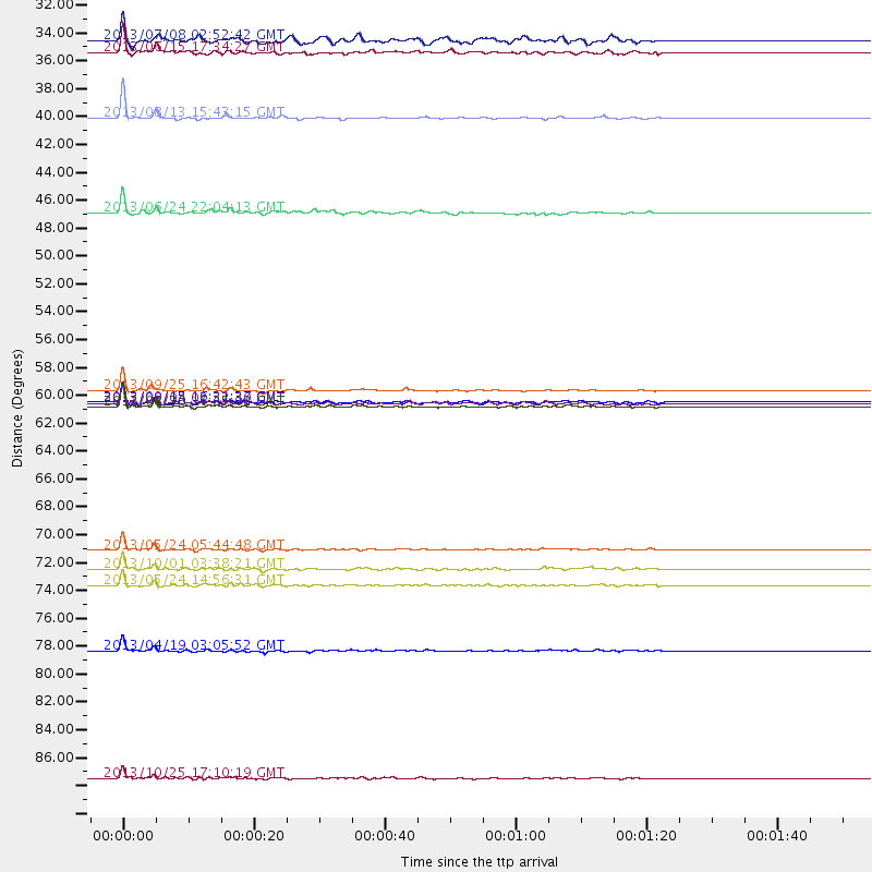
Events Processed for this Station
Download zip of receiver functions as SAC
Plot maxima for each earthquake.
Events Used in the Stack
(13 events)| Radial Match | Distance | Baz | FERegion | Time | Lat/Lon | Depth | Magnitude |
| 98.603325 | 59.5 deg | 175.288 deg | Near Coast Of Peru | 2013/09/25 16:42:43 GMT | (-15.8, -74.5) | 40 km | 7.1 MWW, 6.8 MI, 7.0 MWB, 7.0 MWC, 7.1 MWW, 7.1 MWC |
| 98.38499 | 72.2 deg | 331.452 deg | Sea Of Okhotsk | 2013/05/24 05:44:48 GMT | (54.9, 153.2) | 598 km | 8.4 MW, 7.5 MB, 8.3 MW |
| 97.439476 | 80.2 deg | 327.589 deg | Kuril Islands | 2013/04/19 03:05:52 GMT | (46.2, 150.8) | 110 km | 7.2 MW, 7.1 MB, 7.2 MW |
| 95.6144 | 60.8 deg | 314.679 deg | Andreanof Islands, Aleutian Is. | 2013/08/30 16:25:02 GMT | (51.5, -175.2) | 29 km | 7.0 MWW, 6.5 ML, 6.8 MI, 6.9 MWC, 6.9 MWB, 7.0 MWW, 7.0 MI, 7.0 MWC |
| 94.41177 | 37.9 deg | 179.142 deg | South Of Panama | 2013/08/13 15:43:15 GMT | (5.8, -78.2) | 12 km | 6.7 MWW, 6.6 MWB, 6.7 MWW, 6.7 MWC, 6.7 MI |
| 93.89944 | 90.3 deg | 326.711 deg | Off East Coast Of Honshu, Japan | 2013/10/25 17:10:19 GMT | (37.2, 144.7) | 35 km | 7.1 MWW, 7.1 MWW, 7.1 MWB, 7.1 MWC, 7.2 MWC, 7.5 MI |
| 92.75131 | 60.5 deg | 314.511 deg | Andreanof Islands, Aleutian Is. | 2013/09/04 02:32:30 GMT | (51.6, -174.8) | 20 km | 6.5 MWW, 5.9 ML, 6.3 MWB, 6.5 MI, 6.5 MWC, 6.5 MWW |
| 90.739296 | 74.9 deg | 330.719 deg | Sea Of Okhotsk | 2013/05/24 14:56:31 GMT | (52.2, 151.4) | 624 km | 6.7 MW, 6.7 MB, 6.7 MW |
| 86.435104 | 60.5 deg | 314.507 deg | Andreanof Islands, Aleutian Is. | 2013/09/15 16:21:37 GMT | (51.6, -174.7) | 24 km | 6.1 MWW, 5.7 MI, 5.7 ML, 6.0 MWB, 6.1 MWC, 6.1 MWW |
| 85.52509 | 73.7 deg | 330.614 deg | Sea Of Okhotsk | 2013/10/01 03:38:21 GMT | (53.2, 152.8) | 573 km | 6.7 MWW, 6.7 MWC, 6.8 MWC, 6.8 MWB |
| 84.04094 | 32.8 deg | 194.948 deg | Near Coast Of Nicaragua | 2013/06/15 17:34:27 GMT | (11.8, -86.9) | 30 km | 6.5 MW, 6.1 MB, 6.3 MS, 6.5 MW |
| 81.98039 | 45.5 deg | 125.589 deg | Northern Mid-Atlantic Ridge | 2013/06/24 22:04:13 GMT | (10.7, -42.6) | 10 km | 6.5 MW, 6.1 MB, 6.3 MS, 6.6 MW |
| 80.103325 | 31.8 deg | 199.581 deg | El Salvador | 2013/07/08 02:52:42 GMT | (13.3, -89.2) | 55 km | 5.7 MW, 5.7 MB, 5.7 MW |
Losers
(9 events)| Radial Match | Distance | Baz | FERegion | Time | Lat/Lon | Depth | Magnitude | Reason |
| 78.31295 | 35.8 deg | 151.666 deg | Near Coast Of Venezuela | 2013/10/12 02:10:27 GMT | (10.9, -62.3) | 63 km | 6.0 MWW, 6.0 MWW, 6.0 MWB, 6.0 MWC, 6.0 MI | |
| 77.095856 | 73.9 deg | 56.151 deg | Crete, Greece | 2013/10/12 13:11:53 GMT | (35.5, 23.3) | 40 km | 6.6 MWW, 6.5 MWB, 6.6 MWW, 6.7 MWC | |
| 75.710976 | 59.6 deg | 172.186 deg | Southern Peru | 2013/07/17 02:37:43 GMT | (-15.7, -71.7) | 7.0 km | 6.0 MW, 5.6 MB, 5.8 MS, 5.8 MW | |
| 72.849785 | 75.7 deg | 55.965 deg | Crete, Greece | 2013/06/15 16:11:02 GMT | (34.4, 25.0) | 10 km | 6.2 MW, 6.0 MB, 6.0 MS, 6.1 MW | |
| 72.450264 | 60.5 deg | 314.535 deg | Andreanof Islands, Aleutian Is. | 2013/09/04 06:16:49 GMT | (51.6, -174.8) | 21 km | 5.7 MWW, 5.5 ML, 5.5 MI, 5.7 MWB, 5.7 MWW, 5.8 MWC | |
| 70.36636 | 60.5 deg | 314.346 deg | Andreanof Islands, Aleutian Is. | 2013/09/05 05:43:39 GMT | (51.5, -174.6) | 20 km | 5.6 MWW, 5.4 MI, 5.5 MWB, 5.6 MWW, 5.7 MWC, 5.7 ML, 5.8 MWC | |
| 68.31144 | 60.8 deg | 314.279 deg | Andreanof Islands, Aleutian Is. | 2013/08/31 06:38:36 GMT | (51.2, -174.9) | 18 km | 6.0 MWW, 5.5 ML, 5.9 MWB, 5.9 MWC, 6.0 MWC, 6.0 MI, 6.0 MWW | |
| 60.334896 | 88.8 deg | 328.895 deg | Off East Coast Of Honshu, Japan | 2013/04/01 18:53:17 GMT | (39.5, 143.2) | 14 km | 6.0 MW, 5.6 MB, 5.7 MS, 6.0 MW | |
| 54.54858 | 71.7 deg | 326.382 deg | Off East Coast Of Kamchatka | 2013/05/21 05:43:21 GMT | (52.3, 160.1) | 30 km | 6.1 MW, 5.8 MB, 6.1 MS, 6.1 MW |
